File:AMH-4553-NA Map of Nagapatnam.jpg

Original file (2,400 × 1,700 pixels, file size: 467 KB, MIME type: image/jpeg)
Captions
Captions
Summary
editNederlands: Plattegrond van Nagapatnam
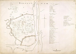
English: Map of Nagapatnam( |
||||||||||||||||||||||||||
|---|---|---|---|---|---|---|---|---|---|---|---|---|---|---|---|---|---|---|---|---|---|---|---|---|---|---|
| Author |
Nederlands: Isaac de Graaff (landmeter / kaartenmaker)
English: Isaac de Graaff (land surveyor / mapmaker) |
|||||||||||||||||||||||||
| Title |
Nederlands: Plattegrond van Nagapatnam
English: Map of Nagapatnam |
|||||||||||||||||||||||||
| Description |
Nederlands: Titel catalogus Leupe (NA): Grondplan van Nagapatnam.
Legenda: A-N; 1-50 Gerestaureerd en duidelijk dubbel gevouwen geweest. Rechts boven genummerd: 25.b. Notities verso: 50 [met potlood, slecht leesbaar] / 587.English: According to the Leupe catalogue (NA), the original title reads: Grondplan van Nagapatnam.
Key: A-N; 1-50 Restored after having clearly been folded double. Numbered top right: 25.b. Notes on reverse: 50 [barely readable, in pencil] / 587. |
|||||||||||||||||||||||||
| Date | between 1700 and 1800 | |||||||||||||||||||||||||
| Medium |
Nederlands: ingekleurde tekening op papier
English: coloured drawing on paper |
|||||||||||||||||||||||||
| Dimensions | height: 75 cm (29.5 in); width: 53.5 cm (21 in) | |||||||||||||||||||||||||
| Collection |
|
|||||||||||||||||||||||||
| Accession number |
NL-HaNA_4.VEL_1082 (old number: VEL1082) |
|||||||||||||||||||||||||
| Inscriptions |
Nagapatnam
|
|||||||||||||||||||||||||
| Notes |
English: Subjects: fortification, chart / map / plan, key
Nederlands: Onderwerpen: vesting, plattegrond / kaart, legenda
English: Post: this image is related to a VOC trading post called Nagappattinam |
|||||||||||||||||||||||||
| Source/Photographer |
|
|||||||||||||||||||||||||
| Permission (Reusing this file) |
|
|||||||||||||||||||||||||

| Object location | | View this and other nearby images on: OpenStreetMap |
|---|
File history
Click on a date/time to view the file as it appeared at that time.
| Date/Time | Thumbnail | Dimensions | User | Comment | |
|---|---|---|---|---|---|
| current | 16:35, 10 June 2014 | | 2,400 × 1,700 (467 KB) | HuskyBot (talk | contribs) | == {{int:filedesc}} == {{Artwork |title = {{nl|1=Plattegrond van Nagapatnam}} {{en|1=Map of Nagapatnam}} |description = {{nl|1=Titel catalogus Leupe (NA): ''Grondplan van Nagapatnam''. Legenda: A-N; 1-50 Gere... |
You cannot overwrite this file.
File usage on Commons
The following page uses this file:
File usage on other wikis
The following other wikis use this file:
- Usage on nl.wikipedia.org