File:AMH-4560-NA Maps of the lodges at Sadrangapatnam and Porto Novo.jpg

Original file (2,400 × 1,710 pixels, file size: 645 KB, MIME type: image/jpeg)
Captions
Captions
Summary edit
Nederlands: Plattegronden van de loges van Sadrangapatnam en Porto Novo
English: Maps of the lodges at Sadrangapatnam and Porto Novo( |
||||||||||||||||||||||||||
|---|---|---|---|---|---|---|---|---|---|---|---|---|---|---|---|---|---|---|---|---|---|---|---|---|---|---|
| Author |
Nederlands: Isaac de Graaff (landmeter / kaartenmaker)
English: Isaac de Graaff (land surveyor / mapmaker) |
|||||||||||||||||||||||||
| Title |
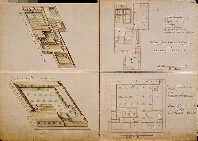
Nederlands: Plattegronden van de loges van Sadrangapatnam en Porto Novo
English: Maps of the lodges at Sadrangapatnam and Porto Novo |
|||||||||||||||||||||||||
| Description |
Nederlands: Titel catalogus Leupe (NA): Platte grond van de Logie tot Sadrangapatnam; 16 Rijnl. roeden = 110 strepen; omgerekende schaal [1 : 547]; Legenda: A-M
VEL1087a: Verheven teekening van genoemde Logie; VEL1087b: Platte grond van de Logie tot Porto Novo; Schaal van 10 Rijnl. roeden = 122 strepen; omgerekende schaal [1 : 308]; Legenda: A-I VEL1087c: Verheven teekening van genoemde Logie; In het midden gerestaureerd, waar de kaart dubbelgevouwen heeft gezeten. Rechts boven genummerd: 25.e. Notities verso: 52 [in potlood] / 588 a.English: According to the Leupe catalogue (NA), the original title reads: Platte grond van de Logie tot Sadrangapatnam; 16 Rhenish rods = 110 stripes, converted scale [1 : 547]; Key: A-M
VEL1087a: Verheven teekening van genoemde Logie; VEL1087b: Platte grond van de Logie tot Porto Novo; Scale of 10 Rhenish rods = 122 stripes; converted scale [1 : 308]; Key: A-I VEL1087c: Verheven teekening van genoemde Logie; Restored in the middle, where the chart was folded in half. Numbered top right: 25.e. Notes on reverse: 52 [in pencil] / 588 a. |
|||||||||||||||||||||||||
| Date | between 1690 and 1705 | |||||||||||||||||||||||||
| Medium |
Nederlands: ingekleurde tekening op papier
English: coloured drawing on paper |
|||||||||||||||||||||||||
| Dimensions | height: 74.5 cm (29.3 in); width: 53.5 cm (21 in) | |||||||||||||||||||||||||
| Collection |
|
|||||||||||||||||||||||||
| Accession number |
NL-HaNA_4.VEL_1087 (old number: VEL1087) |
|||||||||||||||||||||||||
| Inscriptions |
Logie tot Sadrangapatnam / Platte grond van de Logie tot Sadrangapatnam / Logie tot Porto Novo / Platte grond van de Logie tot Porto Novo
|
|||||||||||||||||||||||||
| Notes |
English: Subjects: bird's-eye view / elevation, elevation / bird's-eye view, key, survey / view, chart / map / plan
Nederlands: Onderwerpen: vogelvlucht / opstand, opstand / vogelvlucht, legenda, overzicht / aanzicht, plattegrond / kaart
English: Post: this image is related to a VOC trading post called Parangipettai |
|||||||||||||||||||||||||
| Source/Photographer |
|
|||||||||||||||||||||||||
| Permission (Reusing this file) |
|
|||||||||||||||||||||||||

| Object location | | View this and other nearby images on: OpenStreetMap |
|---|
File history
Click on a date/time to view the file as it appeared at that time.
| Date/Time | Thumbnail | Dimensions | User | Comment | |
|---|---|---|---|---|---|
| current | 16:37, 10 June 2014 | | 2,400 × 1,710 (645 KB) | HuskyBot (talk | contribs) | == {{int:filedesc}} == {{Artwork |title = {{nl|1=Plattegronden van de loges van Sadrangapatnam en Porto Novo}} {{en|1=Maps of the lodges at Sadrangapatnam and Porto Novo}} |description = {{nl|1=Titel catalogus... |
You cannot overwrite this file.
File usage on Commons
The following page uses this file:
File usage on other wikis
The following other wikis use this file:
- Usage on nl.wikipedia.org