File:AMH-4583-NA Map and elevations of the castle at Batavia.jpg

Original file (2,400 × 868 pixels, file size: 208 KB, MIME type: image/jpeg)
Captions
Captions
Summary edit
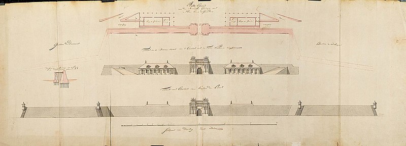
Nederlands: Plattegrond en profielen van het kasteel Batavia
English: Map and elevations of the castle at Batavia( |
||||||||||||||||||||||||
|---|---|---|---|---|---|---|---|---|---|---|---|---|---|---|---|---|---|---|---|---|---|---|---|---|
| Author |
Nederlands: C.A. Luepken (toegeschreven aan landmeter/kaartenmaker), C. van Barnekor (toegeschreven aan landmeter/kaartenmaker)
English: C.A. Luepken (assigned to land surveyor / mapmaker), C. van Barnekor (assigned to land surveyor / mapmaker) |
|||||||||||||||||||||||
| Title |
Nederlands: Plattegrond en profielen van het kasteel Batavia
English: Map and elevations of the castle at Batavia |
|||||||||||||||||||||||
| Description |
Nederlands: Titel catalogus Leupe (NA): Platte grond van de nieuwe gordijnen met de twee Corps de Gardes.
Op de randen geplakt, maar in het midden is een lange strook weer losgeraakt zodat daar een grote scheur zit. Notities verso: (Ý1764) [in potlood] / 1764 [in potlood].English: According to the Leupe catalogue (NA), the original title reads: Platte grond van de nieuwe gordijnen met de twee Corps de Gardes.
The edges have been glued, but in the middle a long strip has come unstuck, resulting in a big tear. Notes on reverse: (Ý1764) [in pencil] / 1764 [in pencil]. |
|||||||||||||||||||||||
| Date | circa 1764 | |||||||||||||||||||||||
| Medium |
Nederlands: ingekleurde tekening op papier
English: coloured drawing on paper |
|||||||||||||||||||||||
| Dimensions | height: 147 cm (57.8 in); width: 52.5 cm (20.6 in) | |||||||||||||||||||||||
| Collection |
|
|||||||||||||||||||||||
| Accession number |
NL-HaNA_4.VEL_1200 (old number: VEL1200) |
|||||||||||||||||||||||
| Inscriptions |
Platte grond van de nieuwe gordijnen met de twee Corps de Gardes
|
|||||||||||||||||||||||
| Notes |
English: Subjects: ornamentation (of building), survey / view, cross-section / profile, fortification, gate
Nederlands: Onderwerpen: ornament (van gebouw), overzicht / aanzicht, doorsnede / profiel, vesting, poort
English: Fort: this image is related to a VOC fort called kasteel Batavia |
|||||||||||||||||||||||
| Source/Photographer |
|
|||||||||||||||||||||||
| Permission (Reusing this file) |
|
|||||||||||||||||||||||

| Object location | | View this and other nearby images on: OpenStreetMap |
|---|
File history
Click on a date/time to view the file as it appeared at that time.
| Date/Time | Thumbnail | Dimensions | User | Comment | |
|---|---|---|---|---|---|
| current | 16:41, 10 June 2014 | 2,400 × 868 (208 KB) | HuskyBot (talk | contribs) | == {{int:filedesc}} == {{Artwork |title = {{nl|1=Plattegrond en profielen van het kasteel Batavia}} {{en|1=Map and elevations of the castle at Batavia}} |description = {{nl|1=Titel catalogus Leupe (NA): ''Platt... |
You cannot overwrite this file.
File usage on Commons
The following page uses this file:
File usage on other wikis
The following other wikis use this file:
- Usage on nl.wikipedia.org