File:AMH-4597-NA Map of Batavia and environs.jpg
Original file (5,106 × 3,894 pixels, file size: 3.53 MB, MIME type: image/jpeg)
Captions
Captions
Summary edit
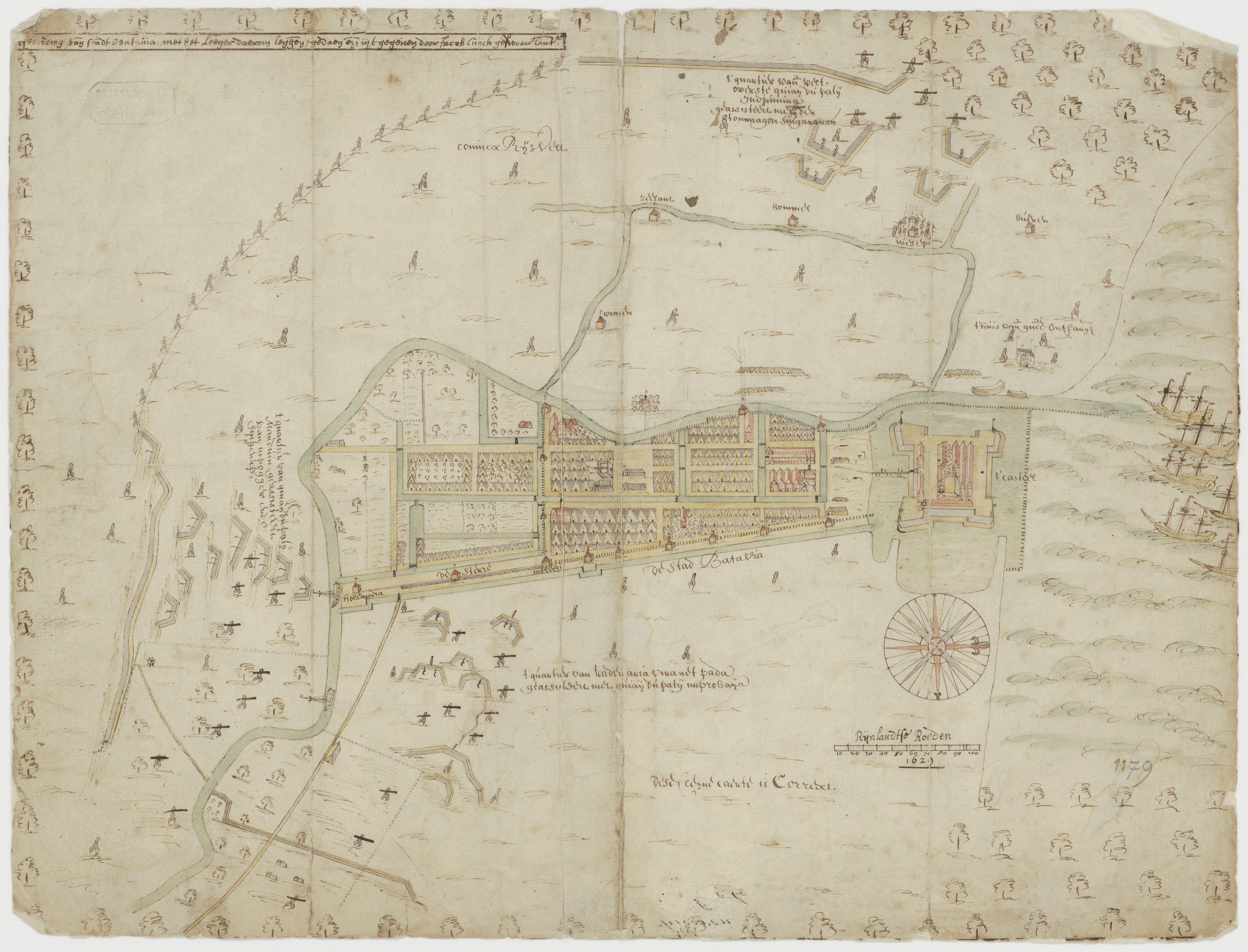
| Nederlands: Plattegrond van Batavia en omstreken
English: Map of Batavia and environs Bahasa Indonesia: Peta Batavia dan sekitarnya( |
||||||||||||||||||||||||
|---|---|---|---|---|---|---|---|---|---|---|---|---|---|---|---|---|---|---|---|---|---|---|---|---|
| Author |
Creator:Jacob Cornelisz van Cuyck Creator:Hessels Gerritsz. Nederlands: Jacob Cornelisz van Cuyck (gewerkt naar), Hessels Gerritsz. (landmeter / kaartenmaker)
English: Jacob Cornelisz van Cuyck (copied after), Hessels Gerritsz. (land surveyor / mapmaker) |
|||||||||||||||||||||||
| Title |
Nederlands: Plattegrond van Batavia en omstreken
English: Map of Batavia and environs
Bahasa Indonesia: Peta Batavia dan sekitarnya |
|||||||||||||||||||||||
| Description |
Nederlands: Titel catalogus Leupe (NA): Afbeelding van de stadt Batavia, met het Leeger daerom leggende; gedaen ende uytgegeven door:.
In potlood genummerd 1179. Op de kaart staat de aantekening dese Cleyne caerte is Corrext, waarschijnlijk een bijschrift van Hessel Gerritsz. In de catalogus Leupe is een verwijzing naar een catalogus van een tentoonstelling Amsterdam 1919 bijgeschreven, alsmede Gravure als copie in F Valentyn en KA 1008 ?. Notities verso: Affteeckeninge vant belegh der stad Batavia a 1629 /a [of o] 823 [in potlood] / 50 R. R op 1 duim schaal = rond 1 : 7200 [in potlood].English: According to the Leupe catalogue (NA), the original title reads: Afbeelding van de stadt Batavia, met het Leeger daerom leggende; gedaen ende uytgegeven door:.
Number in pencil: 1179. The chart bears the following inscription: dese Cleyne caerte is Corrext, probably a remark from Hessel Gerritsz. In an addition, the Leupe catalogue refers to a catalogue of an exhibition in Amsterdam in 1919, as well as the noteGravure als copie in F Valentyn and KA 1008 ?. Notes on reverse: Affteeckeninge vant belegh der stad Batavia a 1629 / a [of o] 823 [in pencil] / 50 R. R op 1 duim schaal = rond 1 : 7200 [in pencil].Bahasa Indonesia: Menurut katalog Leupe (NA), judul aslinya berbunyi: Afbeelding van de stadt Batavia, met het Leeger daerom leggende; gedaen ende uytgegeven door:.
Angka dalam pensil: 1179. Bagan itu memuat tulisan berikut: dese Cleyne caerte is Corrext, probably a remark from Hessel Gerritsz. Selain itu, katalog Leupe mengacu pada katalog pameran di Amsterdam pada tahun 1919, serta catatan Gravure als copie in F Valentyn dan KA 1008 ?. Catatan di belakang: Affteeckeninge vant belegh der stad Batavia a 1629 / a [dari o] 823 [menggunakan pensil] / 50 R. R op 1 duim schaal = rond 1 : 7200 [menggunakan pensil]. |
|||||||||||||||||||||||
| Date | 1629 | |||||||||||||||||||||||
| Medium |
Nederlands: ingekleurde tekening op papier
English: coloured drawing on paper
Bahasa Indonesia: gambar berwarna di atas kertas |
|||||||||||||||||||||||
| Dimensions | height: 43 cm (16.9 in); width: 32 cm (12.5 in) | |||||||||||||||||||||||
| Collection |
|
|||||||||||||||||||||||
| Accession number |
NL-HaNA_4.VEL_1179B (old number: VEL1179B) |
|||||||||||||||||||||||
| Inscriptions |
Afbeelding van stadt Batavia, met het Leeger daerom leggende; gedaen ende uytgegeven door Jacob Cuyck gesworen landm:
author: Jacob Cuyck gesworen landm: |
|||||||||||||||||||||||
| Notes |
English: Subjects: chart / map / plan, fortification, battle / taking / war (fight), Person, anchorage / pier / harbour, ship / vessel, flora, building, compass / dial
Nederlands: Onderwerpen: plattegrond / kaart, vesting, veldslag / oorlog (strijd) / inname, Persoon, rede / haven / pier, schip / vaartuig, flora, gebouw, kompas / windroos
English: Post: this image is related to a VOC trading post called Jakarta |
|||||||||||||||||||||||
| Source/Photographer |
|
|||||||||||||||||||||||
| Permission (Reusing this file) |
|
|||||||||||||||||||||||

| Object location | | View this and other nearby images on: OpenStreetMap |
|---|
File history
Click on a date/time to view the file as it appeared at that time.
| Date/Time | Thumbnail | Dimensions | User | Comment | |
|---|---|---|---|---|---|
| current | 09:20, 7 January 2016 | | 5,106 × 3,894 (3.53 MB) | Timmietovenaar (talk | contribs) | Higher resolution |
| 09:19, 7 January 2016 |  | 5,106 × 3,894 (3.53 MB) | Timmietovenaar (talk | contribs) | Higher resolution | |
| 16:44, 10 June 2014 |  | 2,400 × 1,802 (916 KB) | HuskyBot (talk | contribs) | == {{int:filedesc}} == {{Artwork |title = {{nl|1=Plattegrond van Batavia en omstreken}} {{en|1=Map of Batavia and environs}} |description = {{nl|1=Titel catalogus Leupe (NA): ''Afbeelding van de stadt Batavia,... |
You cannot overwrite this file.
File usage on Commons
The following page uses this file: