File:AMH-4629-NA Map of the Tangerang entrenchment.jpg

Size of this preview: 800 × 378 pixels. Other resolutions: 320 × 151 pixels | 640 × 302 pixels | 1,024 × 484 pixels | 1,280 × 605 pixels | 2,400 × 1,134 pixels.
Original file (2,400 × 1,134 pixels, file size: 267 KB, MIME type: image/jpeg)
Captions
Captions
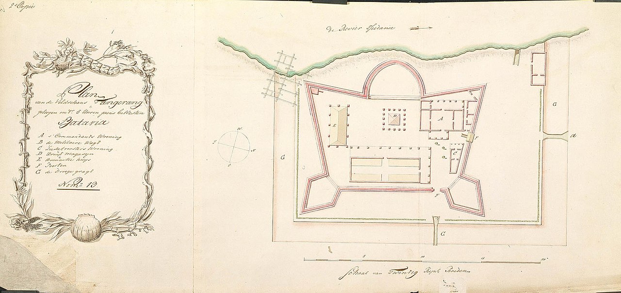
Map of the Tangerang entrenchment
Summary
editNederlands: Plattegrond van de veldschans Tangerang
                     English:  Map of the Tangerang entrenchment
                     Bahasa Indonesia:  Peta kubu Tangerang
( |
||||||||||||||||||||||||
|---|---|---|---|---|---|---|---|---|---|---|---|---|---|---|---|---|---|---|---|---|---|---|---|---|
| Author |
Nederlands: C.A. Luepken (landmeter / kaartenmaker)
English: C.A. Luepken (land surveyor / mapmaker) |
|||||||||||||||||||||||
| Title |
Nederlands: Plattegrond van de veldschans Tangerang
English: Map of the Tangerang entrenchment
Bahasa Indonesia: Peta kubu Tangerang |
|||||||||||||||||||||||
| Description |
Nederlands: Titel catalogus Leupe (NA): Plan van de Veld-Schans Tangerang, geleegen omtrent 5 uuren gaans bewesten Batavia.
Op de kaart staat: 2e Copie. De onderkant is gerafeld. Notities verso: No. 13.b. [staat zowel aan de linkerkant als aan de rechterkant].English: According to the Leupe catalogue (NA), the original title reads: Plan van de Veld-Schans Tangerang, geleegen omtrent 5 uuren gaans bewesten Batavia.
The map is marked: 2e Copie. The lower edge is frayed. Notes on reverse: No. 13.b. [marked on both the left and right hand side].Bahasa Indonesia: Menurut katalog Leupe (NA), judul aslinya berbunyi: Plan van de Veld-Schans Tangerang, geleegen omtrent 5 uuren gaans bewesten Batavia.
Peta ini ditandai dengan: 2e Copie. Tepi bawah terkelupas. Catatan di belakang: No. 13.b." [ditandai di sisi kiri dan kanan]. |
|||||||||||||||||||||||
| Date | circa 1764 | |||||||||||||||||||||||
| Medium |
Nederlands: ingekleurde tekening op papier
English: coloured drawing on paper
Bahasa Indonesia: gambar berwarna di atas kertas |
|||||||||||||||||||||||
| Dimensions | height: 78 cm (30.7 in); width: 36 cm (14.1 in) | |||||||||||||||||||||||
| Collection |
|
|||||||||||||||||||||||
| Accession number |
NL-HaNA_4.VEL_1218 (old number: VEL1218) |
|||||||||||||||||||||||
| Inscriptions |
Plan van de Veldschans Tangerang, geleegen omtr. 5 uuren gaans bewesten Batavia
|
|||||||||||||||||||||||
| Notes |
English: Subjects: chart / map / plan, fortification, banderole / cartouche / ornamentation, compass / dial, key
Nederlands: Onderwerpen: plattegrond / kaart, vesting, banderol / cartouche / versiering, kompas / windroos, legenda
English: Post: this image is related to a VOC trading post called Tangerang |
|||||||||||||||||||||||
| Source/Photographer |
|
|||||||||||||||||||||||
| Permission (Reusing this file) |
|
|||||||||||||||||||||||

| Object location | | View this and other nearby images on: OpenStreetMap |
|---|
File history
Click on a date/time to view the file as it appeared at that time.
| Date/Time | Thumbnail | Dimensions | User | Comment | |
|---|---|---|---|---|---|
| current | 16:50, 10 June 2014 | | 2,400 × 1,134 (267 KB) | HuskyBot (talk | contribs) | == {{int:filedesc}} == {{Artwork |title = {{nl|1=Plattegrond van de veldschans Tangerang}} {{en|1=Map of the Tangerang entrenchment}} |description = {{nl|1=Titel catalogus Leupe (NA): ''Plan van de Veld-Schans... |
You cannot overwrite this file.
File usage on Commons
The following page uses this file: