File:AMH-4683-NA Map of Castle Rotterdam at Macasser.jpg

Original file (2,235 × 2,400 pixels, file size: 669 KB, MIME type: image/jpeg)
Captions
Captions
Summary edit
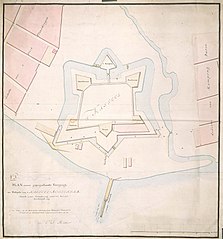
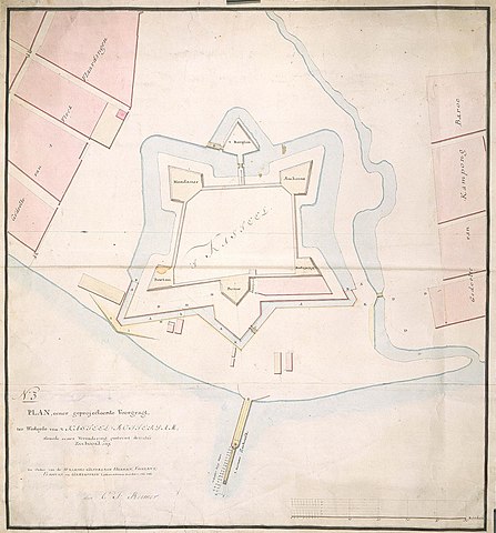
| Nederlands: Plattegrond van kasteel Rotterdam te Macasser
English: Map of Castle Rotterdam at Macasser Bahasa Indonesia: Peta Kastil Rotterdam di Makassar ( |
||||||||||||||||||||||||
|---|---|---|---|---|---|---|---|---|---|---|---|---|---|---|---|---|---|---|---|---|---|---|---|---|
| Author |
Nederlands: Carl Friedrich Reimer (landmeter / kaartenmaker), I.O. Vaillant (opdrachtgever), C.A. Verhuell (opdrachtgever), J.F.L van Gravestein (opdrachtgever)
English: Carl Friedrich Reimer (land surveyor / mapmaker), I.O. Vaillant (patron), C.A. Verhuell (patron), J.F.L van Gravestein (patron) |
|||||||||||||||||||||||
| Title |
Nederlands: Plattegrond van kasteel Rotterdam te Macasser
English: Map of Castle Rotterdam at Macasser
Bahasa Indonesia: Peta Kastil Rotterdam di Makassar |
|||||||||||||||||||||||
| Description |
Nederlands: Titel catalogus Leupe (NA): Plan eener geprojecteerde voorgragt der Westzyde van 't Kasteel Rotterdam, alsmede eener verandering omtrent deszelfs Zeehoofd enz..
Genummerd: No. 3. De randen zijn rondom helemaal beplakt. Notities verso: No. 3 / 652 [met vette cijfers gestempeld op een etiketje].English: According to the Leupe catalogue (NA), the original title reads: Plan eener geprojecteerde voorgragt der Westzyde van 't Kasteel Rotterdam, alsmede eener verandering omtrent deszelfs Zeehoofd enz..
Numbered:No. 3. The edges have all been reinforced. Notes on reverse: No. 3 / 652 [printed in bold on a small label].Bahasa Indonesia: Menurut katalog Leupe (NA), judul aslinya berbunyi: Plan eener geprojecteerde voorgragt der Westzyde van 't Kasteel Rotterdam, alsmede eener verandering omtrent deszelfs Zeehoofd enz..
Diberi nomor:No. 3. Semua tepi telah diperkuat. Catatan di belakang: No. 3 / 652 [dicetak tebal pada label kecil]. |
|||||||||||||||||||||||
| Date | circa 1750 | |||||||||||||||||||||||
| Medium |
Nederlands: ingekleurde tekening op papier
English: coloured drawing on paper
Bahasa Indonesia: gambar berwarna di atas kertas |
|||||||||||||||||||||||
| Dimensions | height: 64.5 cm (25.3 in); width: 69.5 cm (27.3 in) | |||||||||||||||||||||||
| Collection |
|
|||||||||||||||||||||||
| Accession number |
NL-HaNA_4.VEL_1308 (old number: VEL1308) |
|||||||||||||||||||||||
| Inscriptions |
N:o 3 / Plan eener geprojecteerde Voorgragt der Westzyde van 't Kasteel Rotterdam, alsmede eener verandering omtrent deszelfs Zeehoofd enz.
author: door C.F. Reimer |
|||||||||||||||||||||||
| Notes |
English: Subjects: anchorage / pier / harbour, fortification, chart / map / plan
Nederlands: Onderwerpen: rede / haven / pier, vesting, plattegrond / kaart
English: Fort: this image is related to a VOC fort called kasteel Ujung Pandang Rotterdam |
|||||||||||||||||||||||
| Source/Photographer |
|
|||||||||||||||||||||||
| Permission (Reusing this file) |
|
|||||||||||||||||||||||

| Object location | | View this and other nearby images on: OpenStreetMap |
|---|
File history
Click on a date/time to view the file as it appeared at that time.
| Date/Time | Thumbnail | Dimensions | User | Comment | |
|---|---|---|---|---|---|
| current | 17:00, 10 June 2014 | | 2,235 × 2,400 (669 KB) | HuskyBot (talk | contribs) | == {{int:filedesc}} == {{Artwork |title = {{nl|1=Plattegrond van kasteel Rotterdam te Macasser}} {{en|1=Map of Castle Rotterdam at Macasser}} |description = {{nl|1=Titel catalogus Leupe (NA): ''Plan eener gepro... |
You cannot overwrite this file.
File usage on Commons
The following page uses this file: