File:AMH-5090-NA Map of Table Bay and Robben Island.jpg

Original file (1,651 × 2,400 pixels, file size: 668 KB, MIME type: image/jpeg)
Captions
Captions
Summary
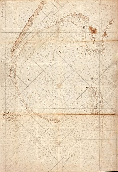
editNederlands: Kaart van de Tafelbaai en Robbeneiland
English: Map of Table Bay and Robben Island( |
||||||||||||||||||||||||
|---|---|---|---|---|---|---|---|---|---|---|---|---|---|---|---|---|---|---|---|---|---|---|---|---|
| Author |
Nederlands: Wilhelm (Jansz.) Blaeu (drukker), Anoniem / Anonymous (landmeter / kaartenmaker)
English: Wilhelm (Jansz.) Blaeu (printer), Anoniem / Anonymous (land surveyor / mapmaker) |
|||||||||||||||||||||||
| Title |
Nederlands: Kaart van de Tafelbaai en Robbeneiland
English: Map of Table Bay and Robben Island |
|||||||||||||||||||||||
| Description |
Nederlands: Titel in catalogus Leupe (Nationaal Archief): Kaart van de Tafelbay en het Robben Eyland.
Kompaslijnen gedrukt bij Willem Blaeu (dit gedrukte papier werd ook na diens sterven in 1638 nog dikwijls gebruikt). Notities verso: 1654 Van de Kaap II deel / 205 [in potlood] / 175 [in rood potlood] / Amsterdam. Legenda: A-DEnglish: Title in Leupe catalogue (National Archives): Kaart van de Tafelbay en het Robben Eyland.
Compass lines printed by Willem Blaeu (this printed paper was used often afther his death in 1638). Notes on the reverse: 1654 Van de Kaap II deel / 205 [in pencil] / 175 [in red pencil] / Amsterdam. Key: A-D |
|||||||||||||||||||||||
| Date | circa 1654 | |||||||||||||||||||||||
| Medium |
Nederlands: pen op papier
English: pen on paper |
|||||||||||||||||||||||
| Dimensions | height: 51.5 cm (20.2 in); width: 74 cm (29.1 in) | |||||||||||||||||||||||
| Collection |
|
|||||||||||||||||||||||
| Accession number |
NL-HaNA_4.VEL_175 (old number: VEL0175) |
|||||||||||||||||||||||
| Notes |
English: Subjects: chart / map / plan, key
Nederlands: Onderwerpen: plattegrond / kaart, legenda |
|||||||||||||||||||||||
| Source/Photographer |
|
|||||||||||||||||||||||
| Permission (Reusing this file) |
|
|||||||||||||||||||||||


| Object location | | View this and other nearby images on: OpenStreetMap |
|---|
File history
Click on a date/time to view the file as it appeared at that time.
| Date/Time | Thumbnail | Dimensions | User | Comment | |
|---|---|---|---|---|---|
| current | 17:15, 10 June 2014 | | 1,651 × 2,400 (668 KB) | HuskyBot (talk | contribs) | == {{int:filedesc}} == {{Artwork |title = {{nl|1=Kaart van de Tafelbaai en Robbeneiland}} {{en|1=Map of Table Bay and Robben Island}} |description = {{nl|1=Titel in catalogus Leupe (Nationaal Archief): ''Kaart... |
You cannot overwrite this file.
File usage on Commons
The following page uses this file: