File:AMH-5121-NA Map of areas belonging to the ruler of Trevancore.jpg
Size of this preview: 800 × 563 pixels. Other resolutions: 320 × 225 pixels | 640 × 450 pixels | 1,024 × 720 pixels | 1,280 × 900 pixels | 2,400 × 1,688 pixels.
Original file (2,400 × 1,688 pixels, file size: 351 KB, MIME type: image/jpeg)
Captions
Captions
Add a one-line explanation of what this file represents
Summary
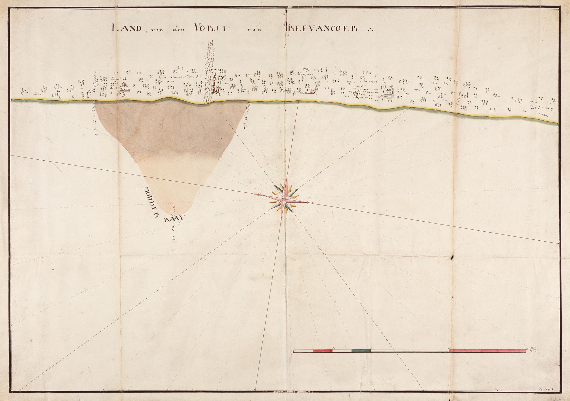
editNederlands: Kaart van gebiedsdelen behorend tot de vorst van Trevancore
English: Map of areas belonging to the ruler of Trevancore( |
||||||||||||||||||||||||
|---|---|---|---|---|---|---|---|---|---|---|---|---|---|---|---|---|---|---|---|---|---|---|---|---|
| Author |
Nederlands: de Preut (landmeter / kaartenmaker)
English: de Preut (land surveyor / mapmaker) |
|||||||||||||||||||||||
| Title |
Nederlands: Kaart van gebiedsdelen behorend tot de vorst van Trevancore
English: Map of areas belonging to the ruler of Trevancore |
|||||||||||||||||||||||
| Description |
Nederlands: Titel in catalogus Leupe (Nationaal Archief): Kaart van de Modderbank op de Kust van het land van den Vorst van Trevancore.
Notities verso: N 2 / 1780 [jaartal van vervaardiging ?] / 30 / La B / 232 [in rood potlood].
English: Title in Leupe catalogue (National Archives): Kaart van de Modderbank op de Kust van het land van den Vorst van Trevancore.
Notes on reverse: N 2 / 1780 [year it was made?] / 30 / La B / 232 [in red pencil]. |
|||||||||||||||||||||||
| Date | between 1700 and 1800 | |||||||||||||||||||||||
| Medium |
Nederlands: ingekleurde gravure op papier
English: coloured engraving on paper |
|||||||||||||||||||||||
| Dimensions | height: 74 cm (29.1 in); width: 51.5 cm (20.2 in) | |||||||||||||||||||||||
| Collection |
|
|||||||||||||||||||||||
| Accession number |
NL-HaNA_4.VEL_232 (old number: VEL0232) |
|||||||||||||||||||||||
| Inscriptions |
Land van den Vorst van Treevancoer
|
|||||||||||||||||||||||
| Notes |
English: Subjects: building, chart / map / plan, compass / dial
Nederlands: Onderwerpen: gebouw, plattegrond / kaart, kompas / windroos |
|||||||||||||||||||||||
| Source/Photographer |
|
|||||||||||||||||||||||
| Permission (Reusing this file) |
|
|||||||||||||||||||||||

File history
Click on a date/time to view the file as it appeared at that time.
| Date/Time | Thumbnail | Dimensions | User | Comment | |
|---|---|---|---|---|---|
| current | 17:21, 10 June 2014 | | 2,400 × 1,688 (351 KB) | HuskyBot (talk | contribs) | == {{int:filedesc}} == {{Artwork |title = {{nl|1=Kaart van gebiedsdelen behorend tot de vorst van Trevancore}} {{en|1=Map of areas belonging to the ruler of Trevancore}} |description = {{nl|1=Titel in catalogus... |
You cannot overwrite this file.
File usage on Commons
The following page uses this file: