File:AMH-5136-NA Map of part of Sumatra and the northern point of Java.jpg
Original file (2,400 × 1,711 pixels, file size: 436 KB, MIME type: image/jpeg)
Captions
Captions
Summary
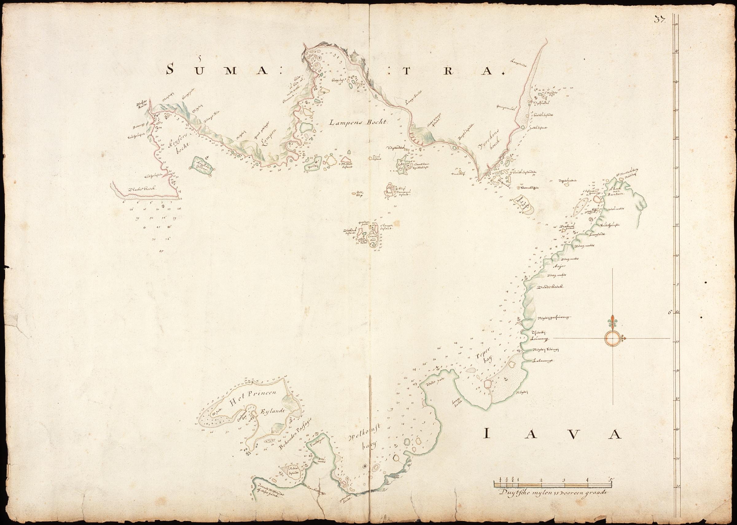
edit| Nederlands: Kaart van een gedeelte van Sumatra en de noordelijke punt van Java
English: Map of part of Sumatra and the northern point of Java ( |
||||||||||||||||||||||||||
|---|---|---|---|---|---|---|---|---|---|---|---|---|---|---|---|---|---|---|---|---|---|---|---|---|---|---|
| Author |
Nederlands: Isaac de Graaff (landmeter / kaartenmaker)
English: Isaac de Graaff (land surveyor / mapmaker) |
|||||||||||||||||||||||||
| Title |
Nederlands: Kaart van een gedeelte van Sumatra en de noordelijke punt van Java
English: Map of part of Sumatra and the northern point of Java |
|||||||||||||||||||||||||
| Description |
Nederlands: Titel in catalogus Leupe (Nationaal Archief): Kaart als voren, hiermee wordt bedoeld de titel van VEL0356: Kaart van Straat Soenda, van het Princen-Eyland tot den Hoek van Bantam.
Rechtsboven genummerd: 37. De randen zijn erg gerafeld. Notities verso: De straat Sunda / 70 43 [in potlood] / 40 [in potlood] / 44 [in potlood].English: Title in the Leupe catalogue (National Archives): Kaart als voren, 'Map as before', referring to the title of VEL0356: Kaart van Straat Soenda, van het Princen-Eyland tot den Hoek van Bantam.
Numbered top right: 37. The edges are badly frayed. Notes on reverse: De straat Sunda / 70 43 [in pencil] / 40 [in pencil] / 44 [in pencil].Bahasa Indonesia: Judul dalam katalog Leupe (Arsip Nasional): Kaart als voren, 'Peta seperti sebelumnya', merujuk pada judul dari VEL0356: Kaart van Straat Soenda, van het Princen-Eyland tot den Hoek van Bantam.
Nomor di kanan atas: 37. Ujung-ujungnya rusak parah. Catatan di belakang: De straat Sunda / 70 43 [dengan pensil] / 40 [dengan pensil] / 44 [dengan pensil]. |
|||||||||||||||||||||||||
| Date | between 1680 and 1730 | |||||||||||||||||||||||||
| Medium |
Nederlands: ingekleurde tekening op papier
English: coloured drawing on paper
Bahasa Indonesia: gambar berwarna di atas kertas |
|||||||||||||||||||||||||
| Dimensions | height: 74.5 cm (29.3 in); width: 52.5 cm (20.6 in) | |||||||||||||||||||||||||
| Collection |
|
|||||||||||||||||||||||||
| Accession number |
NL-HaNA_4.VEL_358 (old number: VEL0358) |
|||||||||||||||||||||||||
| Inscriptions |
Sumatra
|
|||||||||||||||||||||||||
| Notes |
English: Subjects: chart / map / plan
Nederlands: Onderwerpen: plattegrond / kaart
English: Post: this image is related to a VOC trading post called Anyar |
|||||||||||||||||||||||||
| Source/Photographer |
|
|||||||||||||||||||||||||
| Permission (Reusing this file) |
|
|||||||||||||||||||||||||

| Object location | | View this and other nearby images on: OpenStreetMap |
|---|
File history
Click on a date/time to view the file as it appeared at that time.
| Date/Time | Thumbnail | Dimensions | User | Comment | |
|---|---|---|---|---|---|
| current | 17:24, 10 June 2014 | | 2,400 × 1,711 (436 KB) | HuskyBot (talk | contribs) | == {{int:filedesc}} == {{Artwork |title = {{nl|1=Kaart van een gedeelte van Sumatra en de noordelijke punt van Java}} {{en|1=Map of part of Sumatra and the northern point of Java}} |description = {{nl|1=Titel i... |
You cannot overwrite this file.
File usage on Commons
The following page uses this file: