File:AMH-5150-NA Map of the north coast of Java.jpg
Size of this preview: 800 × 569 pixels. Other resolutions: 320 × 228 pixels | 640 × 455 pixels | 1,024 × 728 pixels | 1,280 × 910 pixels | 2,400 × 1,707 pixels.
Original file (2,400 × 1,707 pixels, file size: 404 KB, MIME type: image/jpeg)
Captions
Captions
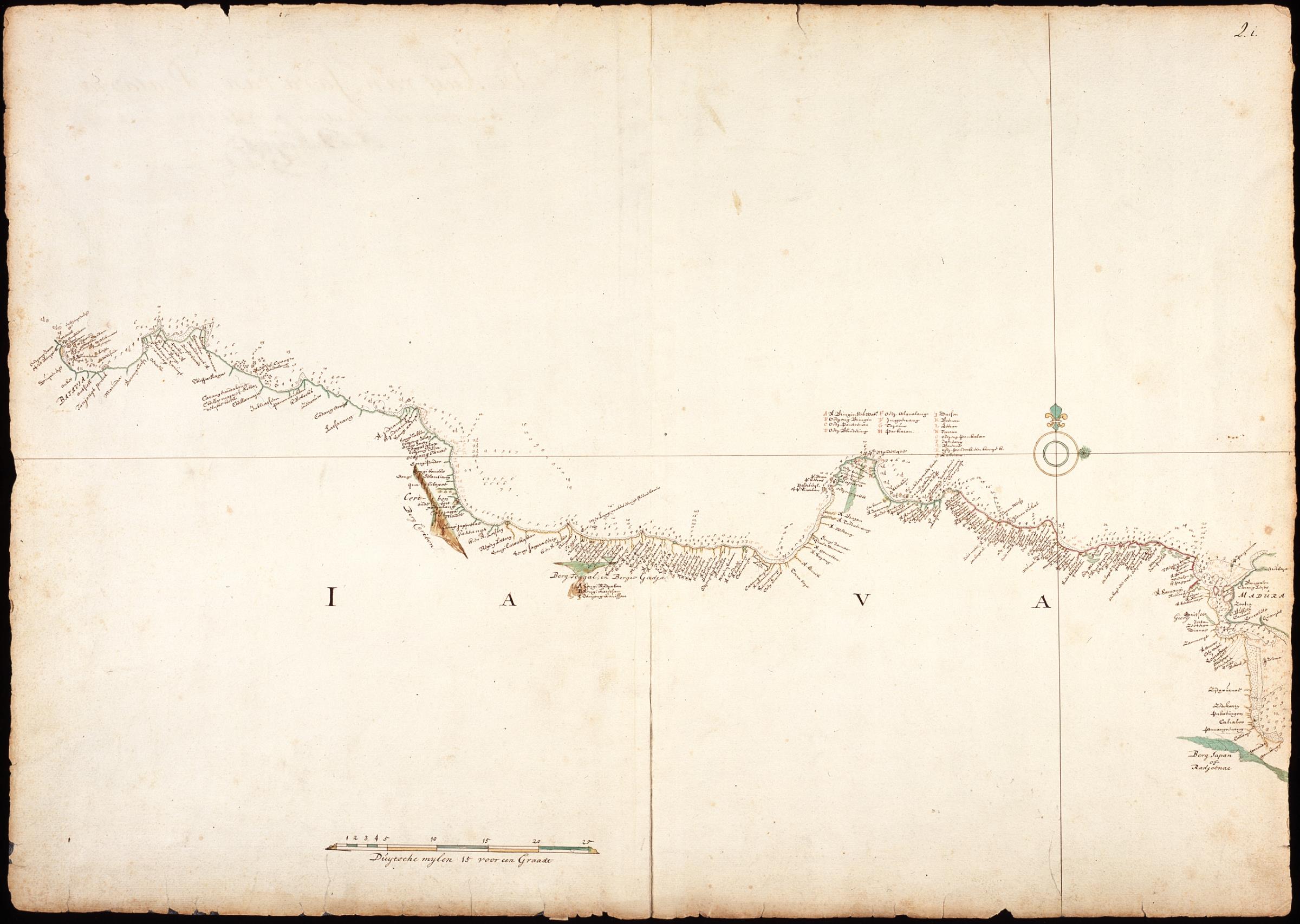
Map of the north coast of Java
Summary
editNederlands: Kaart van de noordkust van Java
                     English:  Map of the north coast of Java
                     Bahasa Indonesia:  Peta pantai utara Pulau Jawa
( |
||||||||||||||||||||||||||
|---|---|---|---|---|---|---|---|---|---|---|---|---|---|---|---|---|---|---|---|---|---|---|---|---|---|---|
| Author |
Nederlands: Isaac de Graaff (landmeter / kaartenmaker)
English: Isaac de Graaff (land surveyor / mapmaker) |
|||||||||||||||||||||||||
| Title |
Nederlands: Kaart van de noordkust van Java
English: Map of the north coast of Java
Bahasa Indonesia: Peta pantai utara Pulau Jawa |
|||||||||||||||||||||||||
| Description |
Nederlands: Titel in catalogus Leupe (Nationaal Archief): Kaart van de Noordkust van Java, van Ondjong Java tot en met de Straat van Madure.
Rechtsboven genummerd: 2.i. Notities verso: De kust van Java van Batavia tot de Straat van Madura / gepeijlt ende bevaren door ? [in potlood] / 51 [in potlood, doorgestreept] / 4 17 45 [in potlood].English: Title in the Leupe catalogue (National Archives): Kaart van de Noordkust van Java, van Ondjong Java tot en met de Straat van Madure.
Numbered top right: 2.i. Notes on reverse: De kust van Java van Batavia tot de Straat van Madura / gepeijlt ende bevaren door ? [in pencil] / 51 [in pencil, crossed out] / 4 17 45 [in pencil].Bahasa Indonesia: Judul dalam katalog Leupe (Arsip Nasional): Kaart van de Noordkust van Java, van Ondjong Java tot en met de Straat van Madure.
Diberi nomor di kanan atas: 2.i. Catatan di belakang: De kust van Java van Batavia tot de Straat van Madura / gepeijlt ende bevaren door ? [dalam pensil] / 51 [dalam pensil, telah dicoret] / 4 17 45 [dalam pensil]. |
|||||||||||||||||||||||||
| Date | between 1690 and 1743 | |||||||||||||||||||||||||
| Medium |
Nederlands: ingekleurde tekening op papier
English: coloured drawing on paper
Bahasa Indonesia: gambar berwarna di atas kertas |
|||||||||||||||||||||||||
| Dimensions | height: 74.5 cm (29.3 in); width: 52.5 cm (20.6 in) | |||||||||||||||||||||||||
| Collection |
|
|||||||||||||||||||||||||
| Accession number |
NL-HaNA_4.VEL_372 (old number: VEL0372) |
|||||||||||||||||||||||||
| Inscriptions |
-
|
|||||||||||||||||||||||||
| Notes |
English: Subjects: compass / dial, chart / map / plan
Nederlands: Onderwerpen: kompas / windroos, plattegrond / kaart
English: Post: this image is related to a VOC trading post called Gresik |
|||||||||||||||||||||||||
| Source/Photographer |
|
|||||||||||||||||||||||||
| Permission (Reusing this file) |
|
|||||||||||||||||||||||||

| Object location | | View this and other nearby images on: OpenStreetMap |
|---|
File history
Click on a date/time to view the file as it appeared at that time.
| Date/Time | Thumbnail | Dimensions | User | Comment | |
|---|---|---|---|---|---|
| current | 17:27, 10 June 2014 | | 2,400 × 1,707 (404 KB) | HuskyBot (talk | contribs) | == {{int:filedesc}} == {{Artwork |title = {{nl|1=Kaart van de noordkust van Java}} {{en|1=Map of the north coast of Java}} |description = {{nl|1=Titel in catalogus Leupe (Nationaal Archief): ''Kaart van de Noor... |
You cannot overwrite this file.
File usage on Commons
The following page uses this file: