File:AMH-5529-NA Map of the Soenda Straits and an insert showing the roadstead of Batavia.jpg
Size of this preview: 800 × 521 pixels. Other resolutions: 320 × 208 pixels | 640 × 417 pixels | 1,024 × 667 pixels | 1,280 × 834 pixels | 2,400 × 1,563 pixels.
Original file (2,400 × 1,563 pixels, file size: 520 KB, MIME type: image/jpeg)
Captions
Captions
Add a one-line explanation of what this file represents
Summary
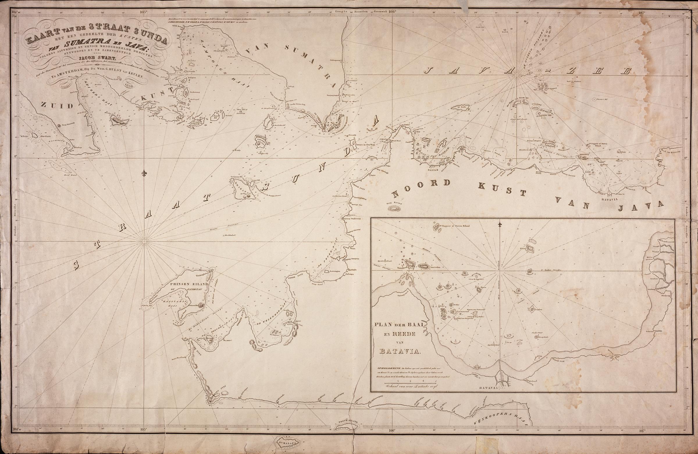
editNederlands: Kaart van de Straat Soenda en een inzet van de rede van Batavia
English: Map of the Soenda Straits and an insert showing the roadstead of Batavia( |
||||||||||||||||||||||||
|---|---|---|---|---|---|---|---|---|---|---|---|---|---|---|---|---|---|---|---|---|---|---|---|---|
| Author |
Creator:Jacob Swart Creator:Wed. Gerard Hulst van Keulen Nederlands: Jacob Swart (landmeter / kaartenmaker), Wed. Gerard Hulst van Keulen (uitgever)
English: Jacob Swart (land surveyor / mapmaker), Wed. Gerard Hulst van Keulen (publisher) |
|||||||||||||||||||||||
| Title |
Nederlands: Kaart van de Straat Soenda en een inzet van de rede van Batavia
English: Map of the Soenda Straits and an insert showing the roadstead of Batavia |
|||||||||||||||||||||||
| Description |
Nederlands: Titel catalogus Leupe (NA): Kaart van de Straat Sunda, met een gedeelte der Kusten van Sumatra en Java enz..
Bijzonderheden: uitgegeven in 1838. Notities verso: No. 5 / 245 a [in potlood] / Kast 1.English: Title in the Leupe catalogue (NA): Kaart van de Straat Sunda, met een gedeelte der Kusten van Sumatra en Java enz..
Particulars: published in 1838. Notes on reverse: No. 5 / 245 a [in pencil] / Kast 1. |
|||||||||||||||||||||||
| Date | 1838 | |||||||||||||||||||||||
| Medium |
Nederlands: koperdruk op papier
English: copperplate printing on paper |
|||||||||||||||||||||||
| Dimensions | height: 102.5 cm (40.3 in); width: 67 cm (26.3 in) | |||||||||||||||||||||||
| Collection |
|
|||||||||||||||||||||||
| Accession number |
NL-HaNA_4.VEL_359 (old number: VEL0359) |
|||||||||||||||||||||||
| Inscriptions |
Kaart van de Straat Sunda met een Gedeelte der Kusten van Sumatra en java; volgens aanwezige en eenige medegedeelde berigten ontworpen en te zamengesteld door Jacob Swart [...] / Plan der Baai en Reede van Batavia author: Te Amsterdam, bij de Wed.G.Hulst van Keulen |
|||||||||||||||||||||||
| Notes |
English: Subjects: chart / map / plan, banderole / cartouche / ornamentation
Nederlands: Onderwerpen: plattegrond / kaart, banderol / cartouche / versiering
English: Post: this image is related to a WIC trading post called Banten |
|||||||||||||||||||||||
| Source/Photographer |
|
|||||||||||||||||||||||
| Permission (Reusing this file) |
|
|||||||||||||||||||||||

| Object location | | View this and other nearby images on: OpenStreetMap |
|---|
File history
Click on a date/time to view the file as it appeared at that time.
| Date/Time | Thumbnail | Dimensions | User | Comment | |
|---|---|---|---|---|---|
| current | 08:25, 11 June 2014 | | 2,400 × 1,563 (520 KB) | HuskyBot (talk | contribs) | == {{int:filedesc}} == {{Artwork |title = {{nl|1=Kaart van de Straat Soenda en een inzet van de rede van Batavia}} {{en|1=Map of the Soenda Straits and an insert showing the roadstead of Batavia}} |description... |
You cannot overwrite this file.
File usage on Commons
The following page uses this file:
File usage on other wikis
The following other wikis use this file:
- Usage on su.wikipedia.org