File:AMH-5606-NA Map of the coast of Malabar, from Suratte to Cape Comorin.jpg

Size of this preview: 776 × 600 pixels. Other resolutions: 311 × 240 pixels | 621 × 480 pixels | 994 × 768 pixels | 1,280 × 989 pixels | 2,400 × 1,855 pixels.
Original file (2,400 × 1,855 pixels, file size: 840 KB, MIME type: image/jpeg)
Captions
Captions
Add a one-line explanation of what this file represents
Summary
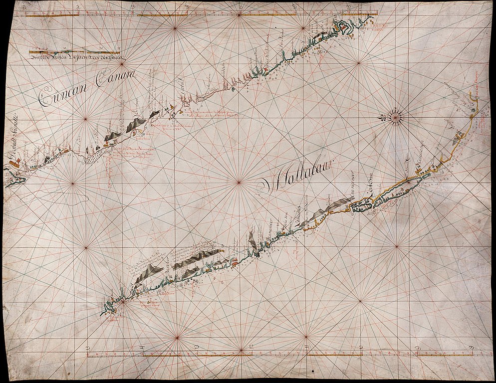
editNederlands: Kaart van de kust van Malabaar, van Suratte tot kaap Comorijn
English: Map of the coast of Malabar, from Suratte to Cape Comorin( |
||||||||||||||||||||||||
|---|---|---|---|---|---|---|---|---|---|---|---|---|---|---|---|---|---|---|---|---|---|---|---|---|
| Author |
Nederlands: Anoniem / Anonymous (landmeter / kaartenmaker)
English: Anoniem / Anonymous (land surveyor / mapmaker) |
|||||||||||||||||||||||
| Title |
Nederlands: Kaart van de kust van Malabaar, van Suratte tot kaap Comorijn
English: Map of the coast of Malabar, from Suratte to Cape Comorin |
|||||||||||||||||||||||
| Description |
Nederlands: Titel catalogus Leupe (NA): Kaart van de kust van Malabaar van Suratte tot kaap Comorijn (in doubletvorm).
Notities verso: Kust Mallebaar
English: Title in the Leupe catalogue (NA): Kaart van de kust van Malabaar van Suratte tot kaap Comorijn (in doubletvorm).
Notes on reverse: Kust Mallebaar |
|||||||||||||||||||||||
| Date | between 1650 and 1700 | |||||||||||||||||||||||
| Medium |
Nederlands: ingekleurde tekening op perkament
English: coloured drawing on parchment |
|||||||||||||||||||||||
| Dimensions | height: 70 cm (27.5 in); width: 89 cm (35 in) | |||||||||||||||||||||||
| Collection |
|
|||||||||||||||||||||||
| Accession number |
NL-HaNA_4.VELH_107 (old number: VELH0107) |
|||||||||||||||||||||||
| Inscriptions |
-
|
|||||||||||||||||||||||
| Notes |
English: Subjects: compass / dial, chart / map / plan
Nederlands: Onderwerpen: kompas / windroos, plattegrond / kaart
English: Post: this image is related to a VOC trading post called Calicut |
|||||||||||||||||||||||
| Source/Photographer |
|
|||||||||||||||||||||||
| Permission (Reusing this file) |
|
|||||||||||||||||||||||

| Object location | | View this and other nearby images on: OpenStreetMap |
|---|
File history
Click on a date/time to view the file as it appeared at that time.
| Date/Time | Thumbnail | Dimensions | User | Comment | |
|---|---|---|---|---|---|
| current | 08:41, 11 June 2014 | | 2,400 × 1,855 (840 KB) | HuskyBot (talk | contribs) | == {{int:filedesc}} == {{Artwork |title = {{nl|1=Kaart van de kust van Malabaar, van Suratte tot kaap Comorijn}} {{en|1=Map of the coast of Malabar, from Suratte to Cape Comorin}} |description = {{nl|1=Titel ca... |
You cannot overwrite this file.
File usage on Commons
The following page uses this file: