File:AMH-6129-NA Map of Cochim, part B.jpg
Original file (2,284 × 2,400 pixels, file size: 416 KB, MIME type: image/jpeg)
Captions
Captions
Summary
editNederlands: Plattegrond van Cochim, deel B
English: Map of Cochim, part B( |
||||||||||||||||||||||||
|---|---|---|---|---|---|---|---|---|---|---|---|---|---|---|---|---|---|---|---|---|---|---|---|---|
| Author |
Creator:J.L. Guyard Creator:W.B.E. Paravicini di Capelli Nederlands: J.L. Guyard (landmeter / kaartenmaker), W.B.E. Paravicini di Capelli (landmeter / kaartenmaker)
English: J.L. Guyard (land surveyor / mapmaker), W.B.E. Paravicini di Capelli (land surveyor / mapmaker) |
|||||||||||||||||||||||
| Title |
Nederlands: Plattegrond van Cochim, deel B
English: Map of Cochim, part B |
|||||||||||||||||||||||
| Description |
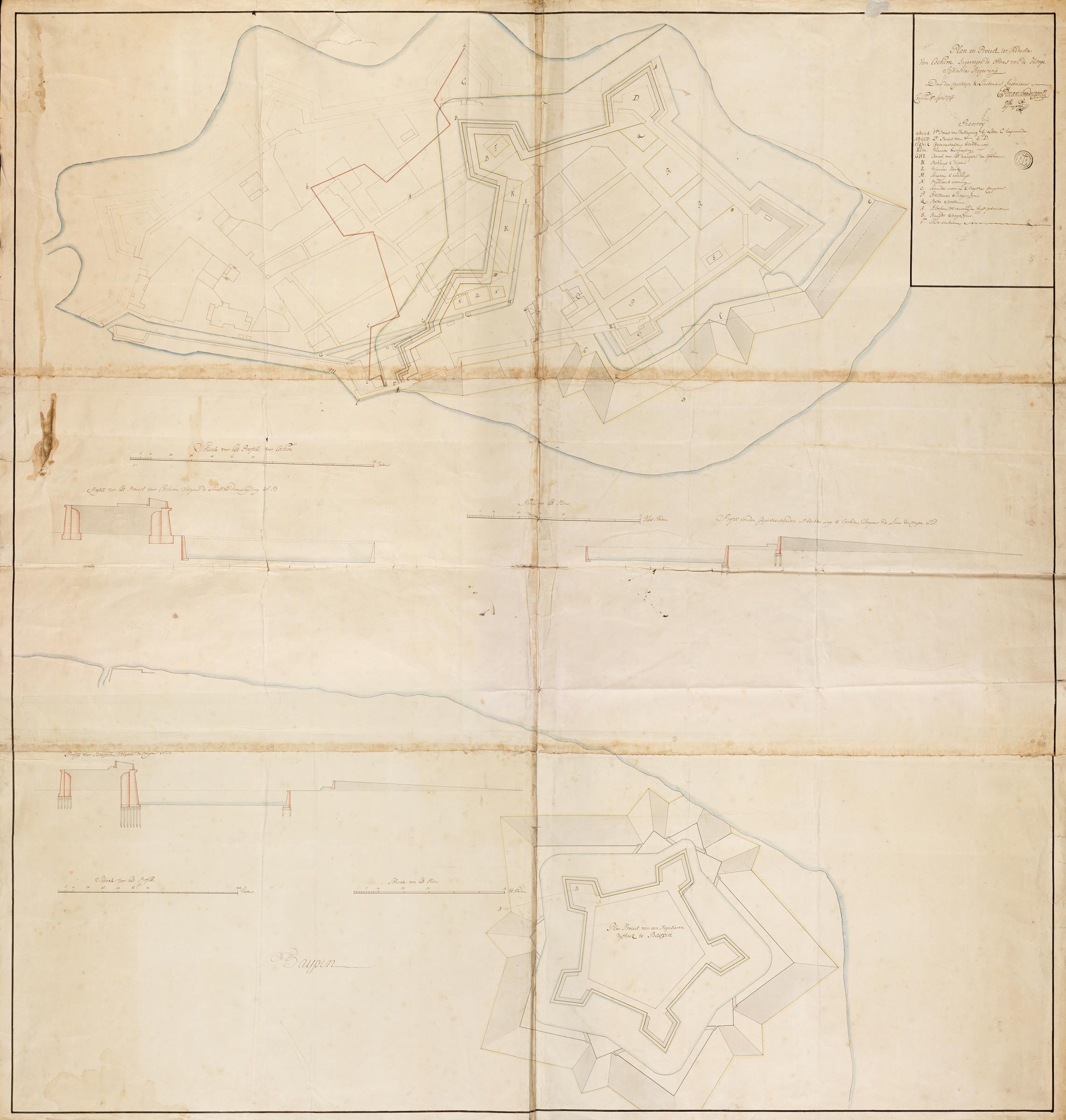
Nederlands: Titel catalogus Leupe (NA): Plan als voren, ingevolge orders van de Hooge Indische Regeering te Batavia, hiermee wordt bedoeld de titel van VEL0901: Plan der Stadt en Fortres, sodanig als hetselve geleegen was in de Maand February 1767, benevens een gedeelte van Baypin, zoodanig als hetzelve ook geleegen was den 1 maart 1767, met deszelfs strekking op de ware distantie enz..
Schaal van 70 Rijnlandse roeden = 213 strepen; omgerekende schaal [1 : 1.237] [plan Cochim]; Schaal van 144 [Rijnlandse ?] voeten = 302 strepen; omgerekende schaal [1 : 149] [profiel Cochim]; Schaal van 60 Rijnlandse roeden = 186 strepen; omgerekende schaal [1 : 1.214] [plan Baypin]; Schaal van 144 [Rijnlandse ?] voeten = 223 strepen; omgerekende schaal [1 : 202] [profiel Baypin]. Met stempeltje Depot des Cart. Pl. et Journ. de la Marine. Notities verso: Cochim 1767, No. 5 Cochim. Register 6, Deel 1, Folio 26, Portefeuille .. [geschreven op een blauw etiket], No. 46, no 168, 504 [met vette cijfers gestempeld op een etiketje]. Rechtboven legenda A-T. De afbeelding toont twee plattegronden Plan Proiect van een Regulieren vijfhoek te Bairpin; Plan en Proiect ter Reductie van Cochim, en drie doorsnedes, met onder meer de aanduiding Profill van het Proiect vooor Cochim, Volgens de Linie ter [?]. Er zijn meerdere schaalverdelingen Schaal voor het Profill voor Cochim.English: Title in the Leupe catalogue (NA): Plan als voren, ingevolge orders van de Hooge Indische Regeering te Batavia, which refers to the title of VEL0901: Plan der Stadt en Fortres, sodanig als hetselve geleegen was in de Maand February 1767, benevens een gedeelte van Baypin, zoodanig als hetzelve ook geleegen was den 1 maart 1767, met deszelfs strekking op de ware distantie enz..
Scale of 70 Rhenish rods = 213 stripes; converted scale [1 : 1.237] [plan Cochim]; scale of 144 [Rhenish ?] feet = 302 stripes; converted scale [1 : 149] [cross section of Cochim]; Scale of 60 Rhenish rods = 186 stripes; converted scale [1 : 1.214] [plan Baypin]; scale of 144 [Rhenish ?] feet = 223 stripes; converted scale [1 : 202] [cross section Baypin]. It bears the stamp: Depot des Cart. Pl. et Journ. de la Marine. Notes on reverse: Cochim 1767, No. 5 Cochim. Register 6, Deel 1, Folio 26, Portefeuille .. [inscribed on a blue label], No. 46, no 168, 504 [stamped in bold on a label]. Top right key A-T. The picture shows two maps Plan Proiect van een Regulieren vijfhoek te Bairpin; Plan en Proiect ter Reductie van Cochim, and three cross sections, including the label Profill van het Proiect vooor Cochim, Volgens de Linie ter [?]. There are several scales Schaal voor het Profill voor Cochim |
|||||||||||||||||||||||
| Date | 1767 | |||||||||||||||||||||||
| Medium |
Nederlands: ingekleurde tekening op papier
English: coloured drawing on paper |
|||||||||||||||||||||||
| Dimensions | height: 133 cm (52.3 in); width: 139.5 cm (54.9 in) | |||||||||||||||||||||||
| Collection |
|
|||||||||||||||||||||||
| Accession number |
NL-HaNA_4.VEL_903B (old number: VEL0903B) |
|||||||||||||||||||||||
| Inscriptions |
Plan en Proiect ter Reductie Van Cochim; Ingevoegen de Ordres van de Hooge Indiasche Regeering
author: Door den Capitayn & Lieutenant Ingenieurs E. Paravicini / N. Guyard / Cochim 14 April 1767 |
|||||||||||||||||||||||
| Notes |
English: Subjects: fortification, key, chart / map / plan, cross-section / profile
Nederlands: Onderwerpen: vesting, legenda, plattegrond / kaart, doorsnede / profiel
English: Post: this image is related to a VOC trading post called Cochin |
|||||||||||||||||||||||
| Source/Photographer |
|
|||||||||||||||||||||||
| Permission (Reusing this file) |
|
|||||||||||||||||||||||

| Object location | | View this and other nearby images on: OpenStreetMap |
|---|
File history
Click on a date/time to view the file as it appeared at that time.
| Date/Time | Thumbnail | Dimensions | User | Comment | |
|---|---|---|---|---|---|
| current | 09:04, 11 June 2014 | | 2,284 × 2,400 (416 KB) | HuskyBot (talk | contribs) | == {{int:filedesc}} == {{Artwork |title = {{nl|1=Plattegrond van Cochim, deel B}} {{en|1=Map of Cochim, part B}} |description = {{nl|1=Titel catalogus Leupe (NA): ''Plan als voren, ingevolge orders van de Hooge... |
You cannot overwrite this file.
File usage on Commons
The following page uses this file: