File:AMH-6926-KB Map of the Cape of Good Hope.jpg
Original file (2,400 × 1,911 pixels, file size: 975 KB, MIME type: image/jpeg)
Captions
Captions
Summary
editNederlands: Kaart van de Kaap de Goede Hoop
English: Map of the Cape of Good Hope( |
||||||||||||||||||||||||||||||||||||||||
|---|---|---|---|---|---|---|---|---|---|---|---|---|---|---|---|---|---|---|---|---|---|---|---|---|---|---|---|---|---|---|---|---|---|---|---|---|---|---|---|---|
| Author |
Nederlands: Weduwe van Jacob van Meurs (uitgever), Johan Nieuhof (tekenaar)
English: Weduwe van Jacob van Meurs (publisher), Johan Nieuhof (draughtsman) |
|||||||||||||||||||||||||||||||||||||||
| Title |
Nederlands: Kaart van de Kaap de Goede Hoop
English: Map of the Cape of Good Hope |
|||||||||||||||||||||||||||||||||||||||
| Description |
Nederlands: Kaart van de Kaap de Goede Hoop.
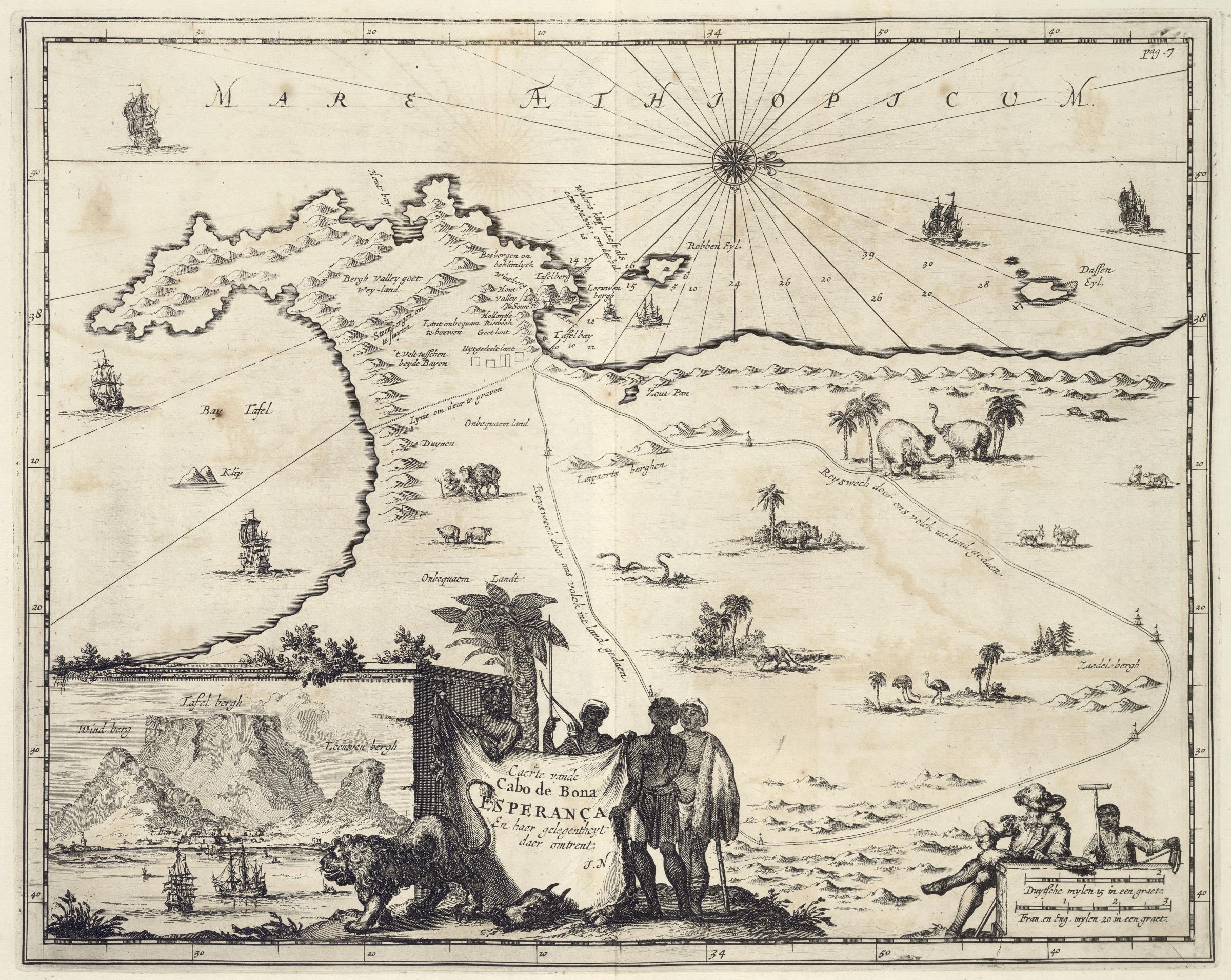
Caerte vande Cabo de Bona Esperança / En haer gelegentheyt daer omtrent. Op de kaart staan verschillende schepen en dieren. Linksonder is een inzet met een gezicht op de Tafelberg te zien. Deze kaart van Kaap de Goede Hoop en de Tafelberg is een van de vele illustraties bij een reisverslag van de Amsterdamse wereldreiziger Johan Nieuhoff. Cf. Koninklijke Bibliotheek, Atlas van der Hagen Deel 4, inv. nr. 1049B13_067. Rechtsboven: pag. 7English: Map of the Cape of Good Hope.
Caerte vande Cabo de Bona Esperança / En haer gelegentheyt daer omtrent. The chart also shows various vessels and animals. Bottom left is an insert showing a view of Table Mountain. This map of the Cape of Good Hope and Table Mountain is one of the many illustrations accompanying a travel journal by the world traveller from Amsterdam, Johan Nieuhoff. Cf. Koninklijke Bibliotheek, Atlas van der Hagen, part 4, inv. nr. 1049B13_067. Top right: pag. 7 |
|||||||||||||||||||||||||||||||||||||||
| Date | circa 1682 | |||||||||||||||||||||||||||||||||||||||
| Medium |
Nederlands: koperdruk op papier
English: copperplate printing on paper |
|||||||||||||||||||||||||||||||||||||||
| Dimensions | height: 36.5 cm (14.3 in); width: 29.5 cm (11.6 in) | |||||||||||||||||||||||||||||||||||||||
| Collection |
|
|||||||||||||||||||||||||||||||||||||||
| Accession number |
388 A 9 deel II, na p. 6 |
|||||||||||||||||||||||||||||||||||||||
| Inscriptions |
Caerte vande Cabo de Bona Esperança / En haer gelegentheyt daer omtrent
author: J.N. |
|||||||||||||||||||||||||||||||||||||||
| Notes |
English: Subjects: chart / map / plan, survey / view, bird's-eye view / elevation, elevation / bird's-eye view, banderole / cartouche / ornamentation, ship / vessel, fauna, compass / dial
Nederlands: Onderwerpen: plattegrond / kaart, overzicht / aanzicht, vogelvlucht / opstand, opstand / vogelvlucht, banderol / cartouche / versiering, schip / vaartuig, fauna, kompas / windroos
English: Post: this image is related to a VOC trading post called Cape Town |
|||||||||||||||||||||||||||||||||||||||
| Source/Photographer |
|
|||||||||||||||||||||||||||||||||||||||
| Permission (Reusing this file) |
|
|||||||||||||||||||||||||||||||||||||||


| Object location | | View this and other nearby images on: OpenStreetMap |
|---|
File history
Click on a date/time to view the file as it appeared at that time.
| Date/Time | Thumbnail | Dimensions | User | Comment | |
|---|---|---|---|---|---|
| current | 11:52, 10 June 2014 | | 2,400 × 1,911 (975 KB) | HuskyBot (talk | contribs) | == {{int:filedesc}} == {{Artwork |title = {{nl|1=Kaart van de Kaap de Goede Hoop}} {{en|1=Map of the Cape of Good Hope}} |description = {{nl|1=Kaart van de Kaap de Goede Hoop. ''Caerte vande Cabo de Bona Esper... |
You cannot overwrite this file.
File usage on Commons
The following page uses this file: