File:AMH-7726-NA Floor plan of the Nassau fort at Mouri.jpg
Original file (1,245 × 2,400 pixels, file size: 443 KB, MIME type: image/jpeg)
Captions
Captions
Summary edit
Nederlands: Plattegrond van het fort Nassau te Mouri
English: Floor plan of the Nassau fort at Mouri( |
||||||||||||||||||||||||
|---|---|---|---|---|---|---|---|---|---|---|---|---|---|---|---|---|---|---|---|---|---|---|---|---|
| Author |
Creator:J. W. van Overmeer Fisscher Nederlands: J. W. van Overmeer Fisscher (landmeter / kaartenmaker)
English: J. W. van Overmeer Fisscher (land surveyor / mapmaker) |
|||||||||||||||||||||||
| Title |
Nederlands: Plattegrond van het fort Nassau te Mouri
English: Floor plan of the Nassau fort at Mouri |
|||||||||||||||||||||||
| Description |
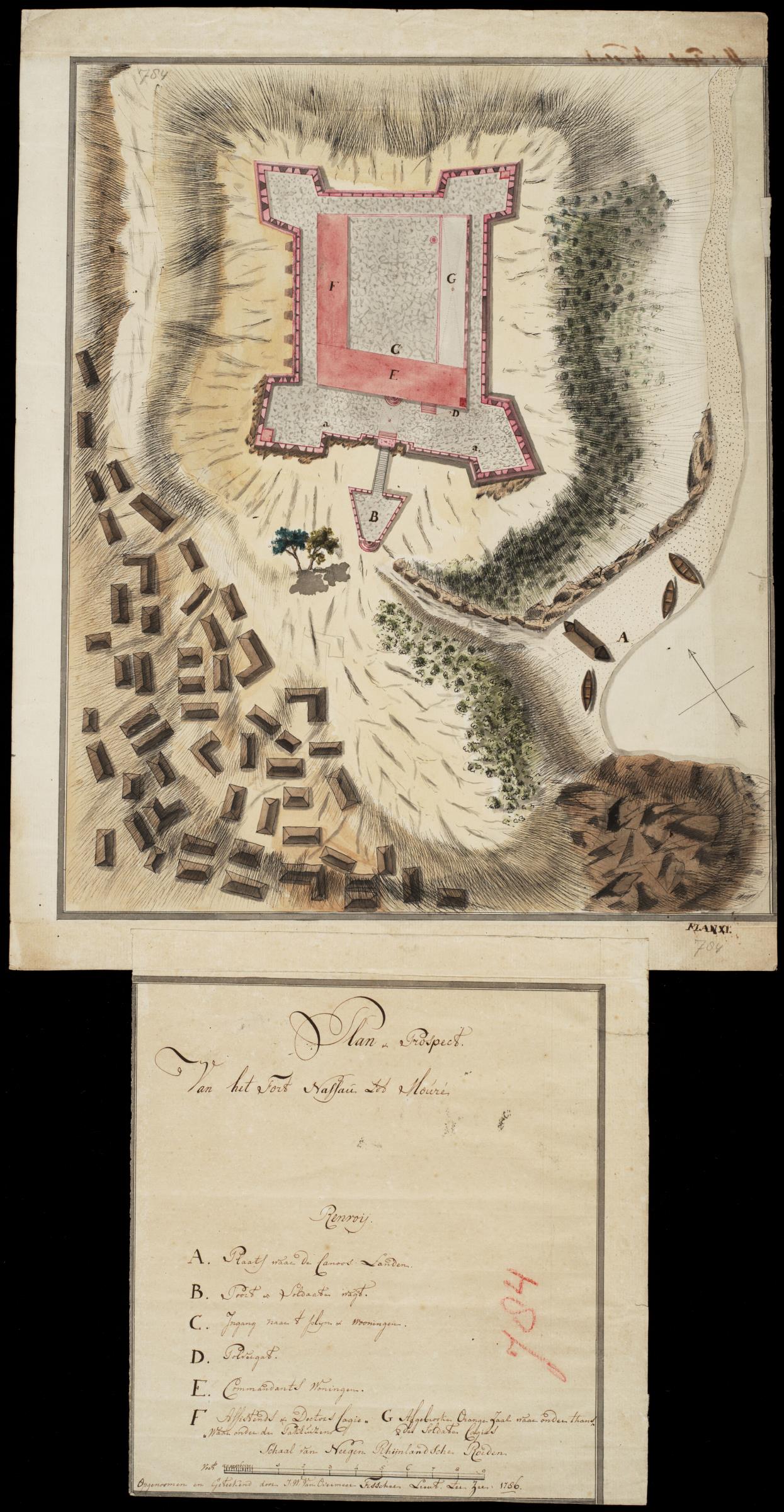
Nederlands: Plattegrond van het fort Nassau te Mouri.
Titel catalogus Leupe (NA): Plan en Prospect van het fort Nassau tot Mouré. Plan-Prospect / Van het Fort nassau tot Mouré. Het formaat van de aan het plan vastgeplakte toelichting is 28 x 25,5 cm. Notities verso: No. 28 Het Fort Nassau. Register 8, Deel 1, Folio 34, Portefeuille .. [geschreven op een blauw etiket] / 478 [met vette cijfers gestempeld op een etiketje] / no. 1 M. Linksboven en rechtsonder op de kaart, rechts op de toelichting: 784 [in potlood]. Rechtsonder: Plan XI:. Legenda: Renvoij / A. Plaats waar de Canoos Landen. / B. Poort & Soldaaten wagt. / C. Ingang naar 't plyn & wooningen / D. Polvergat. / E. Commandants Woningen. / F. Assistends of Doctors Logie,, ,,Waar onder den pakhuizen / G Afgebrooken Orange Zaal waar onder thans des Soldaten Logies.English: Floor plan of the Nassau fort at Mouri.
Title in the Leupe catalogue (NA): Plan en Prospect van het fort Nassau tot Mour??. Plan-Prospect / Van het Fort nassau tot Mour??. The attached notes to the plan measure 28 x 25,5 cm. Notes on reverse: No. 28 Het Fort Nassau. Register 8, Deel 1, Folio 34, Portefeuille .. [inscribed on a blue label] / 478 [stamped in bold on a small label] / no. 1 M. Top left and bottom right on the chart, to the right on the notes: 784 [in pencil]. Bottom right: Plan XI:. Key: Renvoij / A. Plaats waar de Canoos Landen. / B. Poort & Soldaaten wagt. / C. Ingang naar 't plyn & wooningen / D. Polvergat. / E. Commandants Woningen. / F. Assistends of Doctors Logie,, ,,Waar onder den pakhuizen / G Afgebrooken Orange Zaal waar onder thans des Soldaten Logies. |
|||||||||||||||||||||||
| Date | 1786 | |||||||||||||||||||||||
| Medium |
Nederlands: ingekleurde tekening op papier
English: coloured drawing on paper |
|||||||||||||||||||||||
| Dimensions | height: 37.5 cm (14.7 in); width: 47.5 cm (18.7 in) | |||||||||||||||||||||||
| Collection |
|
|||||||||||||||||||||||
| Accession number |
NL-HaNA_4.VEL_784 (old number: VEL0784) |
|||||||||||||||||||||||
| Inscriptions |
Plan-Prospect / Van het Fort nassau tot Mouré
author: Opgenoomen en Geteekend door J: W: Van Overmeer Fisscher Lieut ter Zee : 1786 |
|||||||||||||||||||||||
| Notes |
English: Subjects: fortification, chart / map / plan, key, compass / dial, building, powder magazine / powder mill, house, gate, warehouse, anchorage / pier / harbour, ship / vessel
Nederlands: Onderwerpen: vesting, plattegrond / kaart, legenda, kompas / windroos, gebouw, kruithuis / kruitmolen, huis / woonhuis, poort, pakhuis, rede / haven / pier, schip / vaartuig
English: Post: this image is related to a WIC trading post called Mouri |
|||||||||||||||||||||||
| Source/Photographer |
|
|||||||||||||||||||||||
| Permission (Reusing this file) |
|
|||||||||||||||||||||||

| Object location | | View this and other nearby images on: OpenStreetMap |
|---|
File history
Click on a date/time to view the file as it appeared at that time.
| Date/Time | Thumbnail | Dimensions | User | Comment | |
|---|---|---|---|---|---|
| current | 10:15, 11 June 2014 | | 1,245 × 2,400 (443 KB) | HuskyBot (talk | contribs) | == {{int:filedesc}} == {{Artwork |title = {{nl|1=Plattegrond van het fort Nassau te Mouri}} {{en|1=Floor plan of the Nassau fort at Mouri}} |description = {{nl|1=Plattegrond van het fort Nassau te Mouri. Titel... |
You cannot overwrite this file.
File usage on Commons
The following page uses this file:
File usage on other wikis
The following other wikis use this file:
- Usage on nl.wikipedia.org