File:AMH-7736-NA Floor plan of Fort Crevecoeur at Accra.jpg

Original file (2,400 × 1,940 pixels, file size: 396 KB, MIME type: image/jpeg)
Captions
Captions
Summary
editNederlands: Plattegrond van fort Crevecoeur te Accra
English: Floor plan of Fort Crevecoeur at Accra( |
||||||||||||||||||||||||
|---|---|---|---|---|---|---|---|---|---|---|---|---|---|---|---|---|---|---|---|---|---|---|---|---|
| Author |
Nederlands: Anoniem / Anonymous (landmeter / kaartenmaker)
English: Anoniem / Anonymous (land surveyor / mapmaker) |
|||||||||||||||||||||||
| Title |
Nederlands: Plattegrond van fort Crevecoeur te Accra
English: Floor plan of Fort Crevecoeur at Accra |
|||||||||||||||||||||||
| Description |
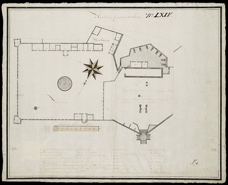
Nederlands: Plattegrond van fort Crevecoeur te Accra.
Titel catalogus Leupe (NA): Het Fortress Crevecoeur tot Accra. Het Fortress Crevecoeur te Accra. Notities verso: No. 35 Fort Crevecoer. Register 8, Deel 1, Folio 35, Portefeuille .. [geschreven op een blauw etiket] / 486 [met vette cijfers gestempeld op een etiketje]. Legenda: 1-32. Rechtsonder: No: 9. Linksonder en rechtsonder: 794 [in potlood]. Rechtsboven: No: LXIV.English: Floor plan of Fort Crevecoeur at Accra.
Title in the Leupe catalogue (NA): Het Fortress Crevecoeur tot Accra. Het Fortress Crevecoeur te Accra. Notes on reverse: No. 35 Fort Crevecoer. Register 8, Deel 1, Folio 35, Portefeuille .. [inscribed on a blue label] / 486 [stamped in bold figures on a small label]. Key: 1-32. Bottom right: No: 9. Bottom left and bottom right: 794 [in pencil]. Top right: No: LXIV. |
|||||||||||||||||||||||
| Date | circa 1790 | |||||||||||||||||||||||
| Medium |
Nederlands: pen en penseel op papier
English: pen and brush on paper |
|||||||||||||||||||||||
| Dimensions | height: 55 cm (21.6 in); width: 44 cm (17.3 in) | |||||||||||||||||||||||
| Collection |
|
|||||||||||||||||||||||
| Accession number |
NL-HaNA_4.VEL_794 (old number: VEL0794) |
|||||||||||||||||||||||
| Inscriptions |
Het Fortress Crevecoeur te Accra
|
|||||||||||||||||||||||
| Notes |
English: Subjects: fortification, key, chart / map / plan, compass / dial, building, tanck / well / watering hole, powder magazine / powder mill, warehouse
Nederlands: Onderwerpen: vesting, legenda, plattegrond / kaart, kompas / windroos, gebouw, tanck / waterplaats / put, kruithuis / kruitmolen, pakhuis
English: Post: this image is related to a WIC trading post called Accra |
|||||||||||||||||||||||
| Source/Photographer |
|
|||||||||||||||||||||||
| Permission (Reusing this file) |
|
|||||||||||||||||||||||

| Object location | | View this and other nearby images on: OpenStreetMap |
|---|
File history
Click on a date/time to view the file as it appeared at that time.
| Date/Time | Thumbnail | Dimensions | User | Comment | |
|---|---|---|---|---|---|
| current | 10:16, 11 June 2014 | | 2,400 × 1,940 (396 KB) | HuskyBot (talk | contribs) | == {{int:filedesc}} == {{Artwork |title = {{nl|1=Plattegrond van fort Crevecoeur te Accra}} {{en|1=Floor plan of Fort Crevecoeur at Accra}} |description = {{nl|1=Plattegrond van fort Crevecoeur te Accra. Titel... |
You cannot overwrite this file.
File usage on Commons
The following page uses this file:
File usage on other wikis
The following other wikis use this file:
- Usage on nl.wikipedia.org