File:AMH-7895-KB Map of the mouth of the Senegal river.jpg

Size of this preview: 425 × 600 pixels. Other resolutions: 170 × 240 pixels | 340 × 480 pixels | 544 × 768 pixels | 725 × 1,024 pixels | 1,700 × 2,400 pixels.
Original file (1,700 × 2,400 pixels, file size: 592 KB, MIME type: image/jpeg)
Captions
Captions
Add a one-line explanation of what this file represents
Summary edit
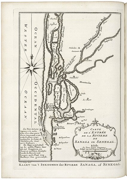
Nederlands: Kaart van de monding van de rivier Senegal
English: Map of the mouth of the Senegal river( |
|||||||||||||||||||||||||||||||||||||||||||||
|---|---|---|---|---|---|---|---|---|---|---|---|---|---|---|---|---|---|---|---|---|---|---|---|---|---|---|---|---|---|---|---|---|---|---|---|---|---|---|---|---|---|---|---|---|---|
| Author |
Nederlands: Anoniem / Anonymous (landmeter / kaartenmaker), Pierre d' Hondt (uitgever), Jacobus van der Schley (graveur / etser)
English: Anoniem / Anonymous (land surveyor / mapmaker), Pierre d' Hondt (publisher), Jacobus van der Schley (engraver / etcher) |
||||||||||||||||||||||||||||||||||||||||||||
| Title |
Nederlands: Kaart van de monding van de rivier Senegal
English: Map of the mouth of the Senegal river |
||||||||||||||||||||||||||||||||||||||||||||
| Description |
Nederlands: Kaart van de monding van de rivier Senegal.
Kaart van 't Inkoomen der Riviere Sanaga, of Senegal. Carte de l'Entrée de la Riviere de Sanaga ou Senegal.English: Map of the mouth of the Senegal river.
Kaart van 't Inkoomen der Riviere Sanaga, of Senegal. Carte de l'Entrée de la Riviere de Sanaga ou Senegal. |
||||||||||||||||||||||||||||||||||||||||||||
| Date | 1747 | ||||||||||||||||||||||||||||||||||||||||||||
| Medium |
Nederlands: gravure op papier
English: engraving on paper |
||||||||||||||||||||||||||||||||||||||||||||
| Dimensions | height: 18.5 cm (7.2 in); width: 26 cm (10.2 in) | ||||||||||||||||||||||||||||||||||||||||||||
| Collection |
|
||||||||||||||||||||||||||||||||||||||||||||
| Accession number |
693 C 6, dl III, na p. 297 |
||||||||||||||||||||||||||||||||||||||||||||
| Inscriptions |
Kaart van 't Inkoomen der Riviere Sanaga, of Senegal
author: J. v. Schley direx. |
||||||||||||||||||||||||||||||||||||||||||||
| Notes |
English: Subjects: chart / map / plan, compass / dial, banderole / cartouche / ornamentation
Nederlands: Onderwerpen: plattegrond / kaart, kompas / windroos, banderol / cartouche / versiering
English: Post: this image is related to a WIC trading post called St. Louis |
||||||||||||||||||||||||||||||||||||||||||||
| Source/Photographer |
|
||||||||||||||||||||||||||||||||||||||||||||
| Permission (Reusing this file) |
|
||||||||||||||||||||||||||||||||||||||||||||

| Object location | | View this and other nearby images on: OpenStreetMap |
|---|
File history
Click on a date/time to view the file as it appeared at that time.
| Date/Time | Thumbnail | Dimensions | User | Comment | |
|---|---|---|---|---|---|
| current | 14:42, 10 June 2014 | | 1,700 × 2,400 (592 KB) | HuskyBot (talk | contribs) | == {{int:filedesc}} == {{Artwork |title = {{nl|1=Kaart van de monding van de rivier Senegal}} {{en|1=Map of the mouth of the Senegal river}} |description = {{nl|1=Kaart van de monding van de rivier Senegal. ''... |
You cannot overwrite this file.
File usage on Commons
The following page uses this file:
File usage on other wikis
The following other wikis use this file:
- Usage on de.wikipedia.org