File:AMH-8021-KB Floor plan of the fort at Cranganor.jpg

Original file (2,400 × 1,716 pixels, file size: 831 KB, MIME type: image/jpeg)
Captions
Captions
Summary
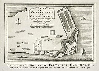
editNederlands: Plattegrond van het fort te Cranganor
English: Floor plan of the fort at Cranganor( |
|||||||||||||||||||||||||||||||||||||||||||||
|---|---|---|---|---|---|---|---|---|---|---|---|---|---|---|---|---|---|---|---|---|---|---|---|---|---|---|---|---|---|---|---|---|---|---|---|---|---|---|---|---|---|---|---|---|---|
| Author |
Nederlands: Jacobus van der Schley (direxit), Pierre d' Hondt (uitgever)
English: Jacobus van der Schley (direxit), Pierre d' Hondt (publisher) |
||||||||||||||||||||||||||||||||||||||||||||
| Title |
Nederlands: Plattegrond van het fort te Cranganor
English: Floor plan of the fort at Cranganor |
||||||||||||||||||||||||||||||||||||||||||||
| Description |
Nederlands: Plattegrond van het fort te Cranganor.
Plan de la Forteresse de Cranganor / Avec ses Ouvrages extérieurs. Grondtékening van de Fortresse Cranganor, / Met de Buyten-Werken, en 't Project van een nieuwe Schans, Gedaan in 't Jaar 1709. De datering van de situatie is 1709, maar de plattegrond is opgenomen in Du Bois' 'Histoire Générale Des Voyages' uit 1752. De afbeelding komt grotendeels overeen met Valentyn, 'Oud en Nieuw-Oostindiën', deel Vb, II, na p. 10. Cf. Koninklijke Bibliotheek, Den Haag, inv. nr. 185 A 5, deel Vb, II, na p. 10 en Scheepvaartmuseum, Amsterdam, inv. nr. SNSM_b0032(109)06[kaart041].English: Floor plan of the fort at Cranganor.
Plan de la Forteresse de Cranganor / Avec ses Ouvrages extérieurs. Grondtékening van de Fortresse Cranganor, / Met de Buyten-Werken, en 't Project van een nieuwe Schans, Gedaan in 't Jaar 1709. The situation is dated 1709, but the floor plan is included in Du Bois' 'Histoire Générale Des Voyages' from 1752. The illustration largely corresponds to that in Valentyn, 'Oud en Nieuw-Oostindiën', part Vb, II, after p. 10. Cf. Koninklijke Bibliotheek, The Hague, inv. nr. 185 A 5, part Vb, II, after p. 10 and Scheepvaartmuseum, Amsterdam, inv. nr. SNSM_b0032(109)06[chart041]. |
||||||||||||||||||||||||||||||||||||||||||||
| Date | 1755 | ||||||||||||||||||||||||||||||||||||||||||||
| Medium |
Nederlands: gravure op papier
English: engraving on paper |
||||||||||||||||||||||||||||||||||||||||||||
| Dimensions | height: 21 cm (8.2 in); width: 15 cm (5.9 in) | ||||||||||||||||||||||||||||||||||||||||||||
| Collection |
|
||||||||||||||||||||||||||||||||||||||||||||
| Accession number |
693 C 6 deel XIII to. p. 390 |
||||||||||||||||||||||||||||||||||||||||||||
| Inscriptions |
Plan de la Forteresse de Cranganor / Grondtékening van de Fortresse Cranganor
author: J. v. Schley direx. |
||||||||||||||||||||||||||||||||||||||||||||
| Notes |
English: Subjects: chart / map / plan, banderole / cartouche / ornamentation, fortification, building, ship / vessel
Nederlands: Onderwerpen: plattegrond / kaart, banderol / cartouche / versiering, vesting, gebouw, schip / vaartuig
English: Post: this image is related to a VOC trading post called Cranganur |
||||||||||||||||||||||||||||||||||||||||||||
| Source/Photographer |
|
||||||||||||||||||||||||||||||||||||||||||||
| Permission (Reusing this file) |
|
||||||||||||||||||||||||||||||||||||||||||||

| Object location | | View this and other nearby images on: OpenStreetMap |
|---|
File history
Click on a date/time to view the file as it appeared at that time.
| Date/Time | Thumbnail | Dimensions | User | Comment | |
|---|---|---|---|---|---|
| current | 15:07, 10 June 2014 | | 2,400 × 1,716 (831 KB) | HuskyBot (talk | contribs) | == {{int:filedesc}} == {{Artwork |title = {{nl|1=Plattegrond van het fort te Cranganor}} {{en|1=Floor plan of the fort at Cranganor}} |description = {{nl|1=Plattegrond van het fort te Cranganor. ''Plan de la F... |
You cannot overwrite this file.
File usage on Commons
The following page uses this file: