File:AMH-8028-KB Floor plan of Fort Rotterdam at Makassar.jpg

Original file (1,733 × 2,400 pixels, file size: 595 KB, MIME type: image/jpeg)
Captions
Captions
Summary
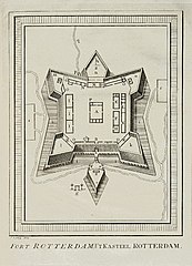
editNederlands: Plattegrond van fort Rotterdam te Makassar
English: Floor plan of Fort Rotterdam at Makassar( |
|||||||||||||||||||||||||||||||||||||||||||||
|---|---|---|---|---|---|---|---|---|---|---|---|---|---|---|---|---|---|---|---|---|---|---|---|---|---|---|---|---|---|---|---|---|---|---|---|---|---|---|---|---|---|---|---|---|---|
| Author |
Nederlands: Jacobus van der Schley (direxit), Pierre d' Hondt (uitgever)
English: Jacobus van der Schley (direxit), Pierre d' Hondt (publisher) |
||||||||||||||||||||||||||||||||||||||||||||
| Title |
Nederlands: Plattegrond van fort Rotterdam te Makassar
English: Floor plan of Fort Rotterdam at Makassar |
||||||||||||||||||||||||||||||||||||||||||||
| Description |
Nederlands: Plattegrond van fort Rotterdam te Makassar.
Fort Rotterdam. 't Kasteel Rotterdam. De legendanummers op de kaart zijn niet verklaard. De afbeelding komt overeen met Valentyn, "Oud en Nieuw Oost-Indiën", deel III b, tweede stuk, voor p. 137: Cf. Koninklijke Bibliotheek, Den Haag, inv. nr. 185 A 5 dl IIIb, II, p. 137.English: Floor plan of Fort Rotterdam at Makassar.
Fort Rotterdam. 't Kasteel Rotterdam. The key numbers on the chart are not accompanied by explanatory notes. The illustration corresponds to Valentyn, "Oud en Nieuw Oost-Indiën", part III b, second part, prior to p. 137: Cf. Koninklijke Bibliotheek, The Hague, inv. nr. 185 A 5 dl IIIb, II, p. 137. |
||||||||||||||||||||||||||||||||||||||||||||
| Date | 1757 | ||||||||||||||||||||||||||||||||||||||||||||
| Medium |
Nederlands: gravure op papier
English: engraving on paper |
||||||||||||||||||||||||||||||||||||||||||||
| Dimensions | height: 11 cm (4.3 in); width: 15 cm (5.9 in) | ||||||||||||||||||||||||||||||||||||||||||||
| Collection |
|
||||||||||||||||||||||||||||||||||||||||||||
| Accession number |
693 C 6 dl XV, to. p. 134 |
||||||||||||||||||||||||||||||||||||||||||||
| Inscriptions |
Fort Rotterdam / 't Kasteel Rotterdam
author: J.v.Schley direx. |
||||||||||||||||||||||||||||||||||||||||||||
| Notes |
English: Subjects: chart / map / plan, fortification, building, key
Nederlands: Onderwerpen: plattegrond / kaart, vesting, gebouw, legenda
English: Post: this image is related to a VOC trading post called Makassar |
||||||||||||||||||||||||||||||||||||||||||||
| Source/Photographer |
|
||||||||||||||||||||||||||||||||||||||||||||
| Permission (Reusing this file) |
|
||||||||||||||||||||||||||||||||||||||||||||

| Object location | | View this and other nearby images on: OpenStreetMap |
|---|
File history
Click on a date/time to view the file as it appeared at that time.
| Date/Time | Thumbnail | Dimensions | User | Comment | |
|---|---|---|---|---|---|
| current | 15:09, 10 June 2014 | | 1,733 × 2,400 (595 KB) | HuskyBot (talk | contribs) | == {{int:filedesc}} == {{Artwork |title = {{nl|1=Plattegrond van fort Rotterdam te Makassar}} {{en|1=Floor plan of Fort Rotterdam at Makassar}} |description = {{nl|1=Plattegrond van fort Rotterdam te Makassar.... |
You cannot overwrite this file.
File usage on Commons
The following page uses this file:
File usage on other wikis
The following other wikis use this file:
- Usage on en.wikipedia.org
- Usage on es.wikipedia.org
- Usage on id.wikipedia.org