File:A Map of South Carolina and a part of Georgia. Containing the whole Sea-coast ; all the islands, inlets, rivers, creeks, parishes, townships, boroughs, roads and bridges - as also several plantations with... - btv1b53177678t (1 of 2).jpg

Original file (14,890 × 16,538 pixels, file size: 29.03 MB, MIME type: image/jpeg)
Captions
Captions
Summary
edit| Warning | The original file is very high-resolution. It might not load properly or could cause your browser to freeze when opened at full size. |
|---|
| Author |
Brahm, William Gérard de (1717-1799). Cartographe Bull, William (17..-1755). Cartographe Gascoigne, John (17..-17..). Cartographe Bryan, Hugh (17..-17..?). Cartographe Jefferys, Thomas (1719?-1771). Graveur |
||||||||||||||||||||||||||
| Title |
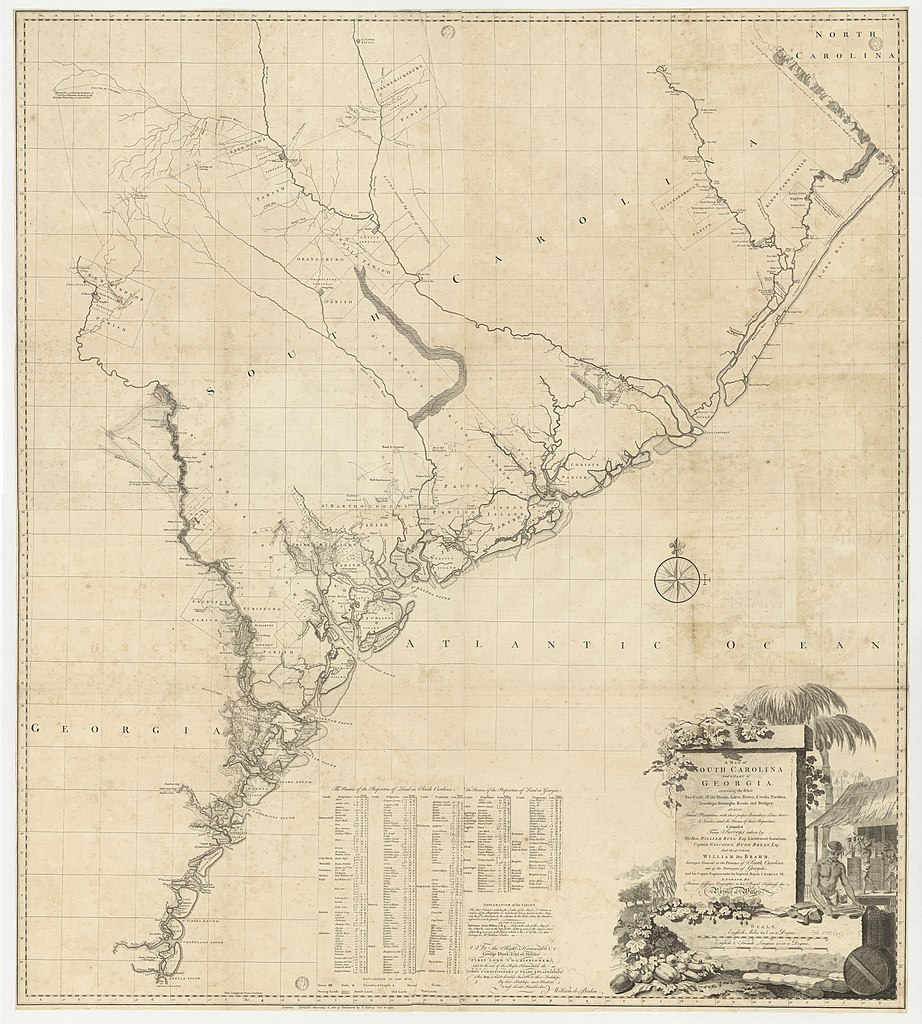
A Map of South Carolina and a part of Georgia. Containing the whole Sea-coast ; all the islands, inlets, rivers, creeks, parishes, townships, boroughs, roads and bridges : as also several plantations with their proper boundary-lines, their names of the names of their proprietors / composed from surveys taken by the hon. William Bull, captain Gascoign, Hugh Bryan and the author William de Brahm.... Engraved by Thomas Jefferys... |
||||||||||||||||||||||||||
| Description |
Français : Sujet : Noirs américains
Sucre (raffineries) Cartouches (ornement) Caroline du Sud, Colonie de -- Plans d'occupation des sols Géorgie, Colonie de la -- Est -- Plans d'occupation des sols Roses des vents Échelle(s) : Scale : 35 english miles 69,5 in a degree [= 17,6 cm] Couverture : États-Unis – Caroline du Sud États-Unis – Géorgie Langue : anglais anglais Éditeur : (London) |
||||||||||||||||||||||||||
| Date | 1757 | ||||||||||||||||||||||||||
| Dimensions | height: 135.5 cm (53.3 in); width: 121.5 cm (47.8 in) | ||||||||||||||||||||||||||
| Collection |
|
||||||||||||||||||||||||||
| References |
Français : Notice de recueil : http://catalogue.bnf.fr/ark:/12148/cb41495064m
Appartient à : Collection géographique du marquis de Paulmy ; 362 Notice du catalogue : http://catalogue.bnf.fr/ark:/12148/cb44459867d |
||||||||||||||||||||||||||
| Source/Photographer |
Français : Bibliothèque nationale de France, département Arsenal, EST-1505 (25)
Bibliothèque nationale de France (1/2) |
||||||||||||||||||||||||||
| Permission (Reusing this file) |
|
||||||||||||||||||||||||||

.jpg&action=edit§ion=1)
.jpg&flash=no)
File history
Click on a date/time to view the file as it appeared at that time.
| Date/Time | Thumbnail | Dimensions | User | Comment | |
|---|---|---|---|---|---|
| current | 10:21, 19 August 2022 | | 14,890 × 16,538 (29.03 MB) | Gzen92Bot (talk | contribs) | Gallica btv1b53177678t |
You cannot overwrite this file.
File usage on Commons
The following page uses this file:
.jpg)
.jpg&oldid=879450349)