File:A Map of the Hawaiian Islands. According to the Latest Surveys, 1838.jpg

Size of this preview: 800 × 526 pixels. Other resolutions: 320 × 210 pixels | 640 × 421 pixels | 1,024 × 673 pixels | 1,280 × 841 pixels | 2,560 × 1,682 pixels | 13,236 × 8,698 pixels.
Original file (13,236 × 8,698 pixels, file size: 35.49 MB, MIME type: image/jpeg)
Captions
Captions
Add a one-line explanation of what this file represents
| Warning | The original file is very high-resolution. It might not load properly or could cause your browser to freeze when opened at full size. |
|---|
Summary
edit| Description |
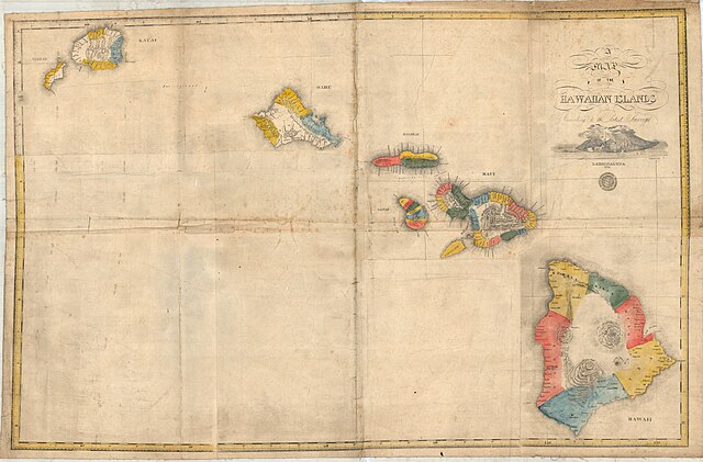
English: A Map of the Hawaiian Islands. According to the Latest Surveys.
Kalama. A map of the Hawaiian Islands according to the latest surveys. Na Kalama i kaha. Lahainaluna: 1838. Col. map, 69 × 106 cm. Scale ca. 1:590,000. (From the collections of the Royal Geographical Society. Pacific Oc.—Dist. Hawaii Islands, 1838 D.188). |
| Date | circa 1838 |
| Source |
http://islandbreath.blogspot.com/2010/06/na-mokupuni-o-hawaii-nei.html |
| Author | Simon P. Kalama |
| Other versions |
|

Licensing
edit
This media file is in the public domain in the United States. This applies to U.S. works where the copyright has expired, often because its first publication occurred prior to January 1, 1929, and if not then due to lack of notice or renewal. See this page for further explanation.
|
 | |
 |
This image might not be in the public domain outside of the United States; this especially applies in the countries and areas that do not apply the rule of the shorter term for US works, such as Canada, Mainland China (not Hong Kong or Macao), Germany, Mexico, and Switzerland. The creator and year of publication are essential information and must be provided. See Wikipedia:Public domain and Wikipedia:Copyrights for more details.
|
File history
Click on a date/time to view the file as it appeared at that time.
| Date/Time | Thumbnail | Dimensions | User | Comment | |
|---|---|---|---|---|---|
| current | 20:00, 9 June 2015 | | 13,236 × 8,698 (35.49 MB) | KAVEBEAR (talk | contribs) |
You cannot overwrite this file.
File usage on Commons
The following 2 pages use this file: