File:A Pocket-Guide to the English Traveller... Cartes 17,18,19,20 de l'atlas - Thomas Gardner - btv1b53056716k (3 of 4).jpg
Original file (3,432 × 2,544 pixels, file size: 1.55 MB, MIME type: image/jpeg)
Captions
Captions
Summary edit
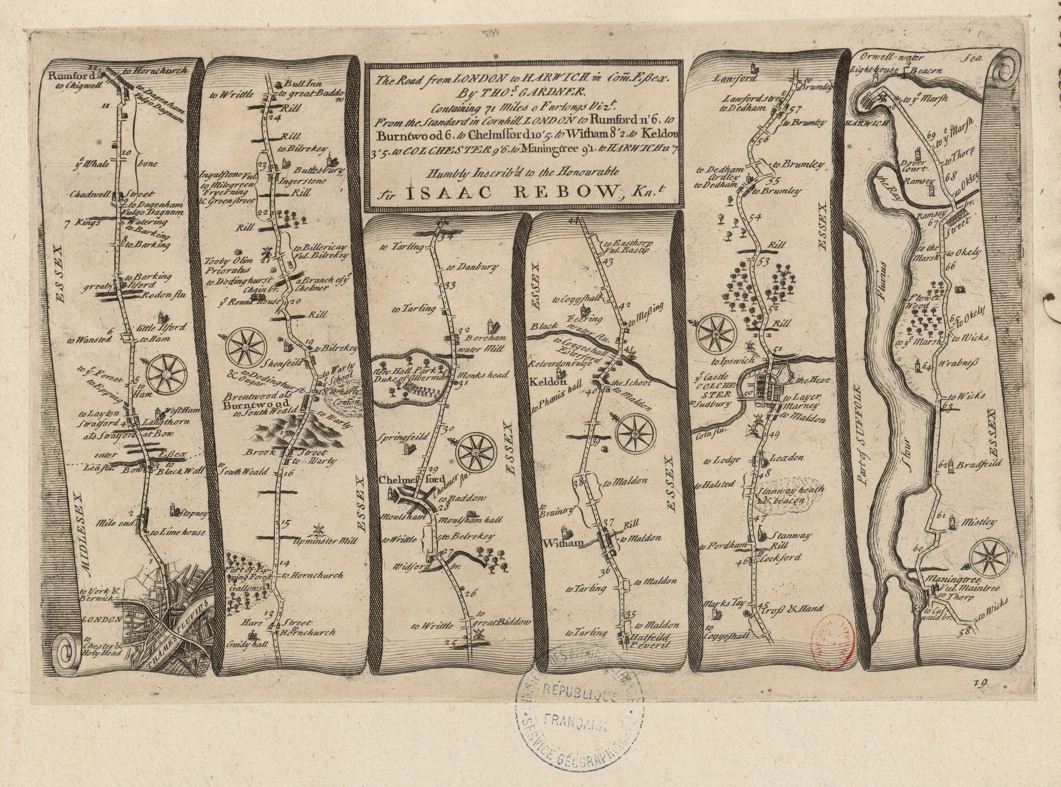
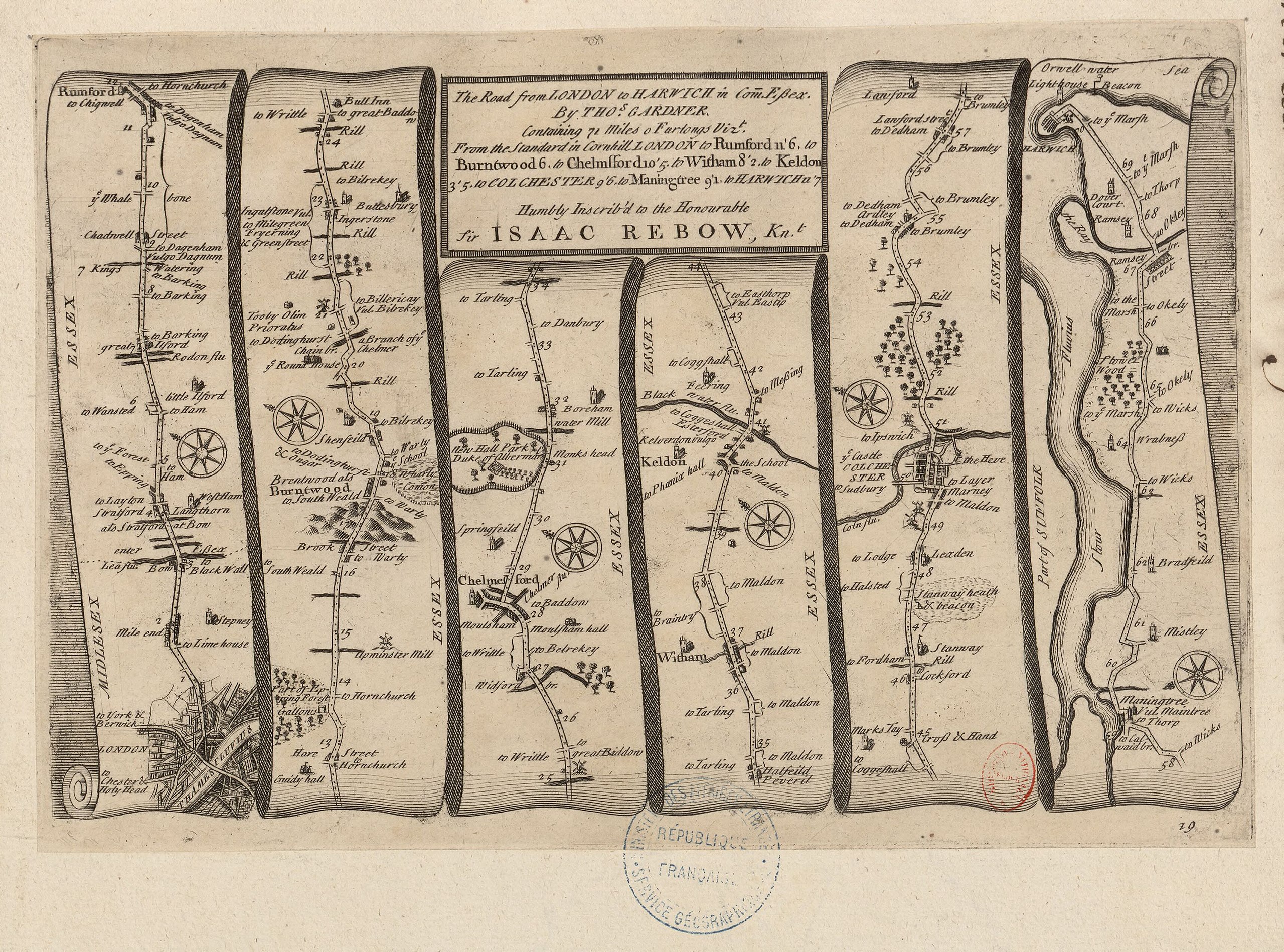
| A Pocket-Guide to the English Traveller... Cartes 17,18,19,20 de l'atlas / Thomas Gardner
( |
|||||||||||||||||||||||||||
|---|---|---|---|---|---|---|---|---|---|---|---|---|---|---|---|---|---|---|---|---|---|---|---|---|---|---|---|
| Author |
Gardner, Thomas (16..-17..). Cartographe |
||||||||||||||||||||||||||
| Title |
A Pocket-Guide to the English Traveller... Cartes 17,18,19,20 de l'atlas / Thomas Gardner |
||||||||||||||||||||||||||
| Description |
Français : Sujet : Essex, Comté d'
Kent, Comté de Middlesex, Comté du Surrey, Comté du Carmarthen, Comté de Glamorgan, Comté de Pembroke, Comté de Échelle(s) : [Sans échelle] Comprend : The Continuation of the Road from London to St Davids ; The Road from London to Dover ; The Road from London to Harwich ; The Road from London to Hith Appartient à l’ensemble documentaire : AnvilEur Appartient à l’ensemble documentaire : MAEDI008 Appartient à l’ensemble documentaire : MAEDIGen0 Couverture : Royaume-Uni – Angleterre Langue : anglais Éditeur : [Printed for J. Tonson... and J. Watts...] (London) |
||||||||||||||||||||||||||
| Date | 1719 | ||||||||||||||||||||||||||
| Dimensions | height: 28 cm (11 in); width: 18 cm (7 in) | ||||||||||||||||||||||||||
| Collection |
|
||||||||||||||||||||||||||
| References |
Français : Notice d'ensemble : http://catalogue.bnf.fr/ark:/12148/cb411851556
Notice de recueil : http://catalogue.bnf.fr/ark:/12148/cb40577015h Appartient à : Collection d'Anville ; 01979-01980 Notice du catalogue : http://catalogue.bnf.fr/ark:/12148/cb411851556 Extrait de A Pocket-Guide to the English Traveller... Printed for J. Tonson... and J. Watts... MDCCXIX [1719], . |
||||||||||||||||||||||||||
| Source/Photographer |
Français : Bibliothèque nationale de France, département Cartes et plans, GE DD-2987 (1979-1980)
Bibliothèque nationale de France (3/4) |
||||||||||||||||||||||||||
| Permission (Reusing this file) |
|
||||||||||||||||||||||||||

.jpg&action=edit§ion=1)
File history
Click on a date/time to view the file as it appeared at that time.
| Date/Time | Thumbnail | Dimensions | User | Comment | |
|---|---|---|---|---|---|
| current | 06:03, 23 July 2022 | | 3,432 × 2,544 (1.55 MB) | Gzen92Bot (talk | contribs) | Gallica btv1b53056716k |
You cannot overwrite this file.
File usage on Commons
The following page uses this file:
.jpg)
.jpg&oldid=825566799)