File:A Snapshot of Sea Ice (4989578009).jpg

Original file (1,280 × 720 pixels, file size: 523 KB, MIME type: image/jpeg)
Captions
Captions
Summary
edit| Description |
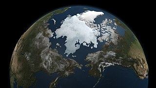
NASA image release September 13, 2010 Caption: This image was compiled using data gathered by NASA's Aqua satellite on Sept. 3, 2010. Credit: NASA/Goddard Space Flight Center Scientific Visualization Studio The Arctic Ocean is covered by a dynamic layer of sea ice that grows each winter and shrinks each summer, reaching its yearly minimum size each fall. While the 2010 minimum remains to be seen, NASA's Aqua satellite captured this snapshot on Sept. 3. How does the Aqua satellite "see" sea ice? Microwaves. Everything on Earth’s surface -- including people -- emits microwave radiation, the properties of which vary with the emitter, thereby allowing the AMSR-E microwave sensor on Aqua to map the planet. Ice emits more microwave radiation than water, making regions of the ocean with floating ice appear much brighter than the open ocean to the AMSR-E sensor. This difference allows the satellite to capture a sea ice record year-round, through cloud cover and the months of polar night. Continuous records are important because sea ice is dynamic. Besides melting and freezing, the ice moves with wind and currents which can cause it to split or pile up. "The data from AMSR-E and other NASA satellites are critical for understanding the coupling between sea ice and the ocean and atmosphere," said Tom Wagner, Cryosphere program manager at NASA Headquarters in Washington. "It’s important for us to understand these connections to improve our predictive models of how the planet will change." The Arctic sea ice is a major factor in the global climate system. The ice cools the planet by reflecting sunlight back into space. It also helps drive ocean circulation by converting the warm Pacific water that flows into the Arctic into the cold, saltier water that empties into the Atlantic. The sea ice also fundamentally shapes the Arctic; defining the organisms that make up its ecosystem and keeping heat from the ocean from melting the frozen tundra. In fall 2009, Arctic sea ice reached its minimum extent on about Sept. 12, and was the third lowest since satellite microwave measurements were first made in 1979. Researchers are interested in year-to-year changes, which can be highly variable, so that scientists need many years, even decades, of data to examine long-term trends. Notably, all of the major minimums have occurred in the last decade, consistent with other NASA research, which shows January 2000 to December 2009 was the warmest decade on record. As the sea ice nears the 2010 minimum later this month, look for images and analysis from NASA and the National Snow and Ice Data Center, in Boulder, Colo. NASA Goddard Space Flight Center contributes to NASA’s mission through four scientific endeavors: Earth Science, Heliophysics, Solar System Exploration, and Astrophysics. Goddard plays a leading role in NASA’s endeavors by providing compelling scientific knowledge to advance the Agency’s mission. Follow us on Twitter Join us on Facebook |
| Date | |
| Source | A Snapshot of Sea Ice |
| Author | NASA Goddard Space Flight Center from Greenbelt, MD, USA |
| Other versions |
a.jpg)
.jpg&action=edit§ion=1)
Licensing
edit.jpg&action=edit§ion=2)
- You are free:
- to share – to copy, distribute and transmit the work
- to remix – to adapt the work
- Under the following conditions:
- attribution – You must give appropriate credit, provide a link to the license, and indicate if changes were made. You may do so in any reasonable manner, but not in any way that suggests the licensor endorses you or your use.
| This image was originally posted to Flickr by NASA Goddard Photo and Video at https://flickr.com/photos/24662369@N07/4989578009. It was reviewed on 27 September 2017 by FlickreviewR and was confirmed to be licensed under the terms of the cc-by-2.0. |
File history
Click on a date/time to view the file as it appeared at that time.
| Date/Time | Thumbnail | Dimensions | User | Comment | |
|---|---|---|---|---|---|
| current | 05:42, 27 September 2017 | | 1,280 × 720 (523 KB) | A1Cafel (talk | contribs) | Transferred from Flickr via Flickr2Commons |
You cannot overwrite this file.
File usage on Commons
The following 2 pages use this file:
.jpg&oldid=776550895)