File:A chart of the North East coast of Great Britain including the islands of Orkney and Shetland - btv1b530097162.jpg

Size of this preview: 800 × 467 pixels. Other resolutions: 320 × 187 pixels | 640 × 374 pixels | 1,024 × 598 pixels | 1,280 × 748 pixels | 2,560 × 1,496 pixels | 16,040 × 9,372 pixels.
Original file (16,040 × 9,372 pixels, file size: 21.5 MB, MIME type: image/jpeg)
Captions
Captions
Add a one-line explanation of what this file represents
Summary
edit| Warning | The original file is very high-resolution. It might not load properly or could cause your browser to freeze when opened at full size. |
|---|
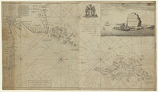
| A chart of the North East coast of Great Britain including the islands of Orkney and Shetland
( |
|||||||||||||||||||||||||||
|---|---|---|---|---|---|---|---|---|---|---|---|---|---|---|---|---|---|---|---|---|---|---|---|---|---|---|---|
| Author |
Chandler, John (17..-18..?). Cartographe |
||||||||||||||||||||||||||
| Title |
A chart of the North East coast of Great Britain including the islands of Orkney and Shetland |
||||||||||||||||||||||||||
| Description |
Français : Sujet : Orcades, Îles
Écosse -- Nord-Est Shetland, Îles Couverture : Royaume-Uni – Écosse Langue : anglais |
||||||||||||||||||||||||||
| Date | 1800 | ||||||||||||||||||||||||||
| Dimensions | height: 133 cm (52.3 in); width: 77 cm (30.3 in) | ||||||||||||||||||||||||||
| Collection |
|
||||||||||||||||||||||||||
| References |
Français : Notice de recueil : http://catalogue.bnf.fr/ark:/12148/cb42246065z
Appartient à : [Division 4 du portefeuille 18 du Service hydrographique de la marine consacrée aux îles Orcades, Ecosse] ; 11 Notice du catalogue : http://catalogue.bnf.fr/ark:/12148/cb422466977 |
||||||||||||||||||||||||||
| Source/Photographer |
Français : Bibliothèque nationale de France, département Cartes et plans, GESH18PF18DIV4P11
Bibliothèque nationale de France |
||||||||||||||||||||||||||
| Permission (Reusing this file) |
|
||||||||||||||||||||||||||

File history
Click on a date/time to view the file as it appeared at that time.
| Date/Time | Thumbnail | Dimensions | User | Comment | |
|---|---|---|---|---|---|
| current | 01:02, 14 July 2022 | | 16,040 × 9,372 (21.5 MB) | Gzen92Bot (talk | contribs) | Gallica btv1b530097162 |
You cannot overwrite this file.
File usage on Commons
The following page uses this file: