File:A new chart of river St Laurence - R. Sayer - btv1b530894367 (01 of 12).jpg
Size of this preview: 561 × 600 pixels. Other resolutions: 224 × 240 pixels | 449 × 480 pixels | 718 × 768 pixels | 958 × 1,024 pixels | 1,915 × 2,048 pixels | 4,960 × 5,304 pixels.
Original file (4,960 × 5,304 pixels, file size: 3.03 MB, MIME type: image/jpeg)
Captions
Captions
Add a one-line explanation of what this file represents
Summary
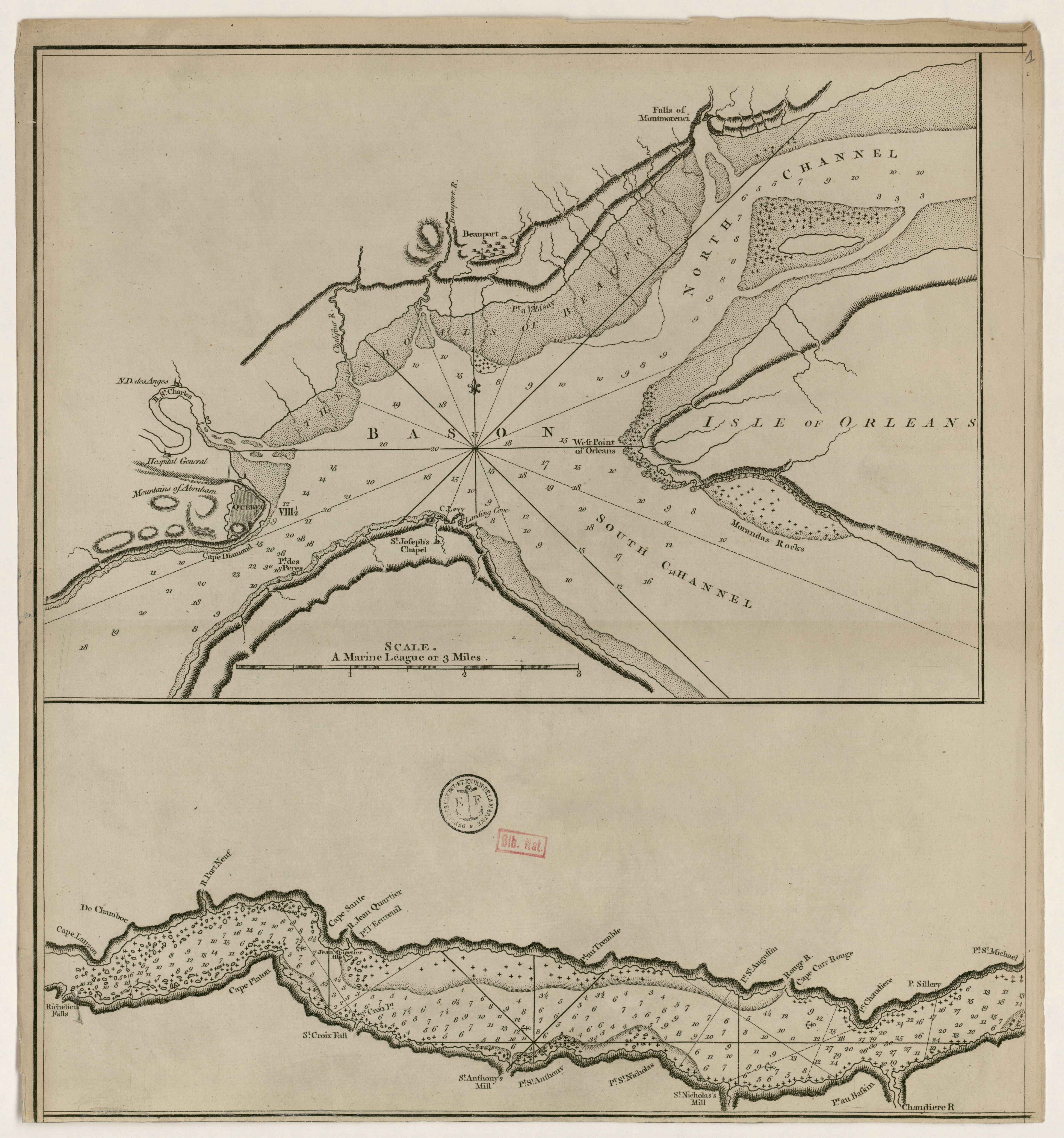
edit| A new chart of river St Laurence / R. Sayer
( |
|||||||||||||||||||||||||||
|---|---|---|---|---|---|---|---|---|---|---|---|---|---|---|---|---|---|---|---|---|---|---|---|---|---|---|---|
| Author |
Sayer, Robert (1724?-1794). Cartographe |
||||||||||||||||||||||||||
| Title |
A new chart of river St Laurence / R. Sayer |
||||||||||||||||||||||||||
| Description |
Français : Langue : anglais |
||||||||||||||||||||||||||
| Date | 1775 | ||||||||||||||||||||||||||
| Dimensions | height: 41 cm (16.1 in); width: 44 cm (17.3 in) | ||||||||||||||||||||||||||
| Collection |
|
||||||||||||||||||||||||||
| References |
Français : Notice de recueil : http://catalogue.bnf.fr/ark:/12148/cb43640397s
Appartient à : [Division 1 du portefeuille 126 du Service hydrographique de la marine consacrée aux cartes générales du fleuve St Laurent] ; 27/2 D Notice du catalogue : http://catalogue.bnf.fr/ark:/12148/cb43640893s |
||||||||||||||||||||||||||
| Source/Photographer |
Français : Bibliothèque nationale de France, département Cartes et plans, GE SH 18 PF 126 DIV 1 P 27/2 D
Bibliothèque nationale de France (1/12) |
||||||||||||||||||||||||||
| Permission (Reusing this file) |
|
||||||||||||||||||||||||||

.jpg&action=edit§ion=1)
File history
Click on a date/time to view the file as it appeared at that time.
| Date/Time | Thumbnail | Dimensions | User | Comment | |
|---|---|---|---|---|---|
| current | 23:35, 16 July 2022 | | 4,960 × 5,304 (3.03 MB) | Gzen92Bot (talk | contribs) | Gallica btv1b530894367 |
You cannot overwrite this file.
File usage on Commons
The following page uses this file:
.jpg)
.jpg&oldid=825570808)