File:A new chart of the China, with its several entrances - drawn from a great number of draughts, journals and other nautical documents, regulated by astronomical observations - btv1b532332997.jpg

Original file (7,616 × 11,348 pixels, file size: 11.51 MB, MIME type: image/jpeg)
Captions
Captions
Summary edit
| Warning | The original file is very high-resolution. It might not load properly or could cause your browser to freeze when opened at full size. |
|---|
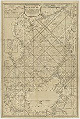
| A new chart of the China, with its several entrances : drawn from a great number of draughts, journals and other nautical documents, regulated by astronomical observations
( |
|||||||||||||||||||||||||||
|---|---|---|---|---|---|---|---|---|---|---|---|---|---|---|---|---|---|---|---|---|---|---|---|---|---|---|---|
| Title |
A new chart of the China, with its several entrances : drawn from a great number of draughts, journals and other nautical documents, regulated by astronomical observations |
||||||||||||||||||||||||||
| Description |
Français : Sujet : Sondages sous-marins
Chine Méridionale, Mer de Chine -- Côtes Paracels, Archipel des Tonkin, Royaume de -- Côtes Cochinchine, Royaume de -- Côtes Hainan, Île de -- Côtes Taïwan (île) -- Côtes Philippines -- Côtes Bornéo, Île de -- Côtes Échelle(s) : [Echelle non mentionnée] Couverture : Chine Viêt Nam Mer de Chine Méridionale Mer de Célèbes Mer de Java Indonésie Philippines Langue : anglais Éditeur : published by Laurie & Whittle (London) |
||||||||||||||||||||||||||
| Date | 1794 | ||||||||||||||||||||||||||
| Dimensions | height: 60 cm (23.6 in); width: 92 cm (36.2 in) | ||||||||||||||||||||||||||
| Collection |
|
||||||||||||||||||||||||||
| References |
Français : Notice d'ensemble : http://catalogue.bnf.fr/ark:/12148/cb46872256s
Notice de recueil : http://catalogue.bnf.fr/ark:/12148/cb46747766w Appartient à : [Portefeuille 182 du Service hydrographique de la Marine consacré aux mers de Chine : cartes nouvelles] ; 10, 10 (1-5) Notice du catalogue : http://catalogue.bnf.fr/ark:/12148/cb46872256s |
||||||||||||||||||||||||||
| Source/Photographer |
Français : Bibliothèque nationale de France, département Cartes et plans, GE SH 18 PF 182 P 10/4
Bibliothèque nationale de France |
||||||||||||||||||||||||||
| Permission (Reusing this file) |
|
||||||||||||||||||||||||||

File history
Click on a date/time to view the file as it appeared at that time.
| Date/Time | Thumbnail | Dimensions | User | Comment | |
|---|---|---|---|---|---|
| current | 05:18, 16 August 2022 | | 7,616 × 11,348 (11.51 MB) | Gzen92Bot (talk | contribs) | Gallica btv1b532332997 |
You cannot overwrite this file.
File usage on Commons
The following page uses this file: