File:Abandoned farm and crop markings - geograph.org.uk - 55168.jpg
No higher resolution available.
Abandoned_farm_and_crop_markings_-_geograph.org.uk_-_55168.jpg (640 × 427 pixels, file size: 181 KB, MIME type: image/jpeg)
Captions
Captions
Add a one-line explanation of what this file represents
Summary
edit
| Description |
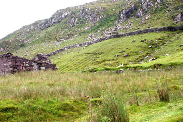
English: Abandoned farm and crop markings. On the steep sides of Killary Harbour, adjacent to the 'famine road' built as part of a poor relief scheme during the potato blight of 1845-49, there are a number of abandoned farms. In the field above the derelict building you can see the parallel banks created by earthing up a potato crop over a period of years. |
| Date | |
| Source | From geograph.org.uk |
| Author | Kevin Danks |
| Attribution (required by the license) | Kevin Danks / Abandoned farm and crop markings / |
| Camera location | | View this and other nearby images on: OpenStreetMap |
|---|
_&language=en)
Licensing
edit

|
This image was taken from the Geograph project collection. See this photograph's page on the Geograph website for the photographer's contact details. The copyright on this image is owned by Kevin Danks and is licensed for reuse under the Creative Commons Attribution-ShareAlike 2.0 license.
|
This file is licensed under the Creative Commons Attribution-Share Alike 2.0 Generic license.
Attribution: Kevin Danks
- You are free:
- to share – to copy, distribute and transmit the work
- to remix – to adapt the work
- Under the following conditions:
- attribution – You must give appropriate credit, provide a link to the license, and indicate if changes were made. You may do so in any reasonable manner, but not in any way that suggests the licensor endorses you or your use.
- share alike – If you remix, transform, or build upon the material, you must distribute your contributions under the same or compatible license as the original.
File history
Click on a date/time to view the file as it appeared at that time.
| Date/Time | Thumbnail | Dimensions | User | Comment | |
|---|---|---|---|---|---|
| current | 12:43, 30 January 2010 | | 640 × 427 (181 KB) | GeographBot (talk | contribs) | == {{int:filedesc}} == {{Information |description={{en|1=Abandoned farm and crop markings. On the steep sides of Killary Harbour, adjacent to the 'famine road' built as part of a poor relief scheme during the potato blight of 1845-49, there are a number o |
You cannot overwrite this file.
File usage on Commons
There are no pages that use this file.
File usage on other wikis
The following other wikis use this file:
- Usage on ca.wikipedia.org