File:Gare de Abela - S. Domingos - GazetaCF 1090 1933.jpg
(Redirected from File:Abela Sao Domingos Railway Station 2.jpg)

Size of this preview: 800 × 563 pixels. Other resolutions: 320 × 225 pixels | 640 × 451 pixels | 916 × 645 pixels.
Original file (916 × 645 pixels, file size: 107 KB, MIME type: image/jpeg)
Captions
Captions
Add a one-line explanation of what this file represents
Summary edit
| Description |
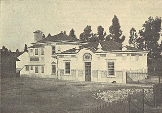
Português: Edifício da Estação Ferroviária de Abela - São Domingos, na Linha de Sines, em Portugal.
Esta fotografia foi publicada na Gazeta dos Caminhos de Ferro n.º 1090, de 16 de Maio de 1933, e digitalizada pela Hemeroteca Municipal de Lisboa. NOTA: Esta imagem tem uma legenda errada na fonte original, onde se identificava a fotografia como sendo da estação de São Bartolomeu da Serra. Esta mesma imagem foi novamente publicada na Gazeta dos Caminhos de Ferro n.º 1078, de 16 de Novembro de 1932 (http://hemerotecadigital.cm-lisboa.pt/OBRAS/GazetaCF/1932/N1078/N1078_item1/P3.html]), mas com a identificação correcta. Ambas as estações são muito semelhantes, mas a de São Bartolomeu tem a secção de dois pisos no outro lado do edifício principal.English: Main building of the Abela - São Domingos Railway Station, on the Sines Railway, in Portugal.
This photograph was originally published in the Gazeta dos Caminhos de Ferro No. 1090, of the 16th May 1933, and scanned by the Hemeroteca Municipal de Lisboa.
NOTE: Image subject is misidentified at the indicated source as the station at S. Bartolomeu da Serra. The same image was published, in the same periodical (Gazeta dos Caminhos de Ferro magazine No. 1078, of 16th November 1932 [1]) with the correct identification. That this is the Abela station can be verified from other photographs showing the other side of the building, with the station name visible. The Bartolomeu station was very similar, but the two story section was at the opposite end. |
| Date | from 1919 until 1933 |
| Source | http://hemerotecadigital.cm-lisboa.pt/OBRAS/GazetaCF/1933/N1090/N1090_item1/P18.html |
| Author | Unknown author |
| Camera location | | View this and other nearby images on: OpenStreetMap |
|---|
Licensing edit
This image (or other media file) is in the public domain because its copyright has expired and its author is anonymous.
This applies to the European Union and those countries with a copyright term of 70 years after the work was made available to the public and the author never disclosed their identity. Important: Always mention where the image comes from, as far as possible, and make sure the author never claimed authorship. |
 | |
 |
Note: In Germany and possibly other countries, certain anonymous works published before July 1, 1995 are copyrighted until 70 years after the death of the author. See Übergangsrecht. Please use this template only if the author never claimed authorship or their authorship never became public in any other way. If the work is anonymous or pseudonymous (e.g., published only under a corporate or organization's name), use this template for images published more than 70 years ago.
For a work made available to the public in the United Kingdom, please use Template:PD-UK-unknown instead.
|
File history
Click on a date/time to view the file as it appeared at that time.
| Date/Time | Thumbnail | Dimensions | User | Comment | |
|---|---|---|---|---|---|
| current | 14:39, 26 May 2014 | | 916 × 645 (107 KB) | Ajpvalente (talk | contribs) | User created page with UploadWizard |
You cannot overwrite this file.
File usage on Commons
The following 5 pages use this file:
- User:Jcornelius/Portugal Public Transport/2014 March 11-20
- User:Jcornelius/Portugal Public Transport/2014 May 21-31
- File:Abela Sao Domingos Railway Station.jpg (file redirect)
- File:Abela Sao Domingos Railway Station 2.jpg (file redirect)
- File:São Bartolomeu da Serra Railway Station.jpg (file redirect)
File usage on other wikis
The following other wikis use this file:
- Usage on pt.wikipedia.org