File:AbombOperationSandstoneApril1948.png
Size of this preview: 377 × 599 pixels. Other resolutions: 151 × 240 pixels | 453 × 720 pixels.
Original file (453 × 720 pixels, file size: 325 KB, MIME type: image/png)
Captions
Captions
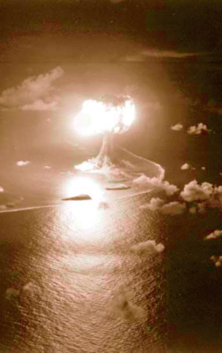
Operation Sandstone - Event X-Ray
Summary edit
| Description |
English: A-bomb-test Operation Sandstone, Event X-Ray detonation, April 15, 1948, Engebi, Eniwetok-Atoll
Deutsch: Operation Sandstone - X-Ray (Explosionshöhe: 61 Meter; 37 kt) Das Luftbild wurde aus etwa 500 Metern Höhe aufgenommen, der gekrümmte Rand der Lagune ist vor der Insel Engebi zu erkennen |
| Date | |
| Source | Former Defenses Nuclear Agency (DNA) |
| Author | U.S. Air Force 1352nd Photographic Group, Lookout Mountain Station |
Licensing edit
This image is a work of a U.S. military or Department of Defense employee, taken or made as part of that person's official duties. As a work of the U.S. federal government, the image is in the public domain in the United States.
|
 |
File history
Click on a date/time to view the file as it appeared at that time.
| Date/Time | Thumbnail | Dimensions | User | Comment | |
|---|---|---|---|---|---|
| current | 01:56, 10 February 2007 | | 453 × 720 (325 KB) | Wikifreund (talk | contribs) | {{Information |Description=A-bomb-test Operation Sandstone, Event X-Ray detonation, April 15, 1948, Engebi, Eniwetok-Atoll |Source=http://www.dtra.mil, former Defenses Nuclear Agency (DNA) |Date=15 April 1948 |Author=unknown |Permission={{PD-USGov-Militar |
You cannot overwrite this file.
File usage on Commons
There are no pages that use this file.
File usage on other wikis
The following other wikis use this file:
- Usage on ar.wikipedia.org
- Usage on ast.wikipedia.org
- Usage on bh.wikipedia.org
- Usage on bn.wikipedia.org
- Usage on ca.wikipedia.org
- Usage on de.wikipedia.org
- Usage on en.wikipedia.org
- Usage on es.wikipedia.org
- Usage on eu.wikipedia.org
- Usage on fa.wikipedia.org
- Usage on fi.wikipedia.org
- Usage on fr.wikipedia.org
- Opération Sandstone
- Portail:Nucléaire
- Wikipédia:Sélection/Nucléaire
- Wikipédia:Lumière sur/Décembre 2012
- Wikipédia:Lumière sur/Opération Sandstone
- Utilisateur:Cantons-de-l'Est/Contributions
- Wikipédia:Sélection/Forces armées des États-Unis
- Wikipédia:Sélection/États-Unis/Bons articles/Partie III
- Utilisateur:Alexandre Mangiapan/Brouillon
- X-Ray (essai atomique)
- Wikipédia:Sélection/Amérique du Nord
- Usage on gl.wikipedia.org
- Usage on he.wikipedia.org
- Usage on hi.wikipedia.org
- Usage on ja.wikipedia.org
- Usage on ko.wikipedia.org
- Usage on mk.wikipedia.org
- Usage on ml.wikipedia.org
- Usage on ms.wikipedia.org
- Usage on pl.wikipedia.org
View more global usage of this file.