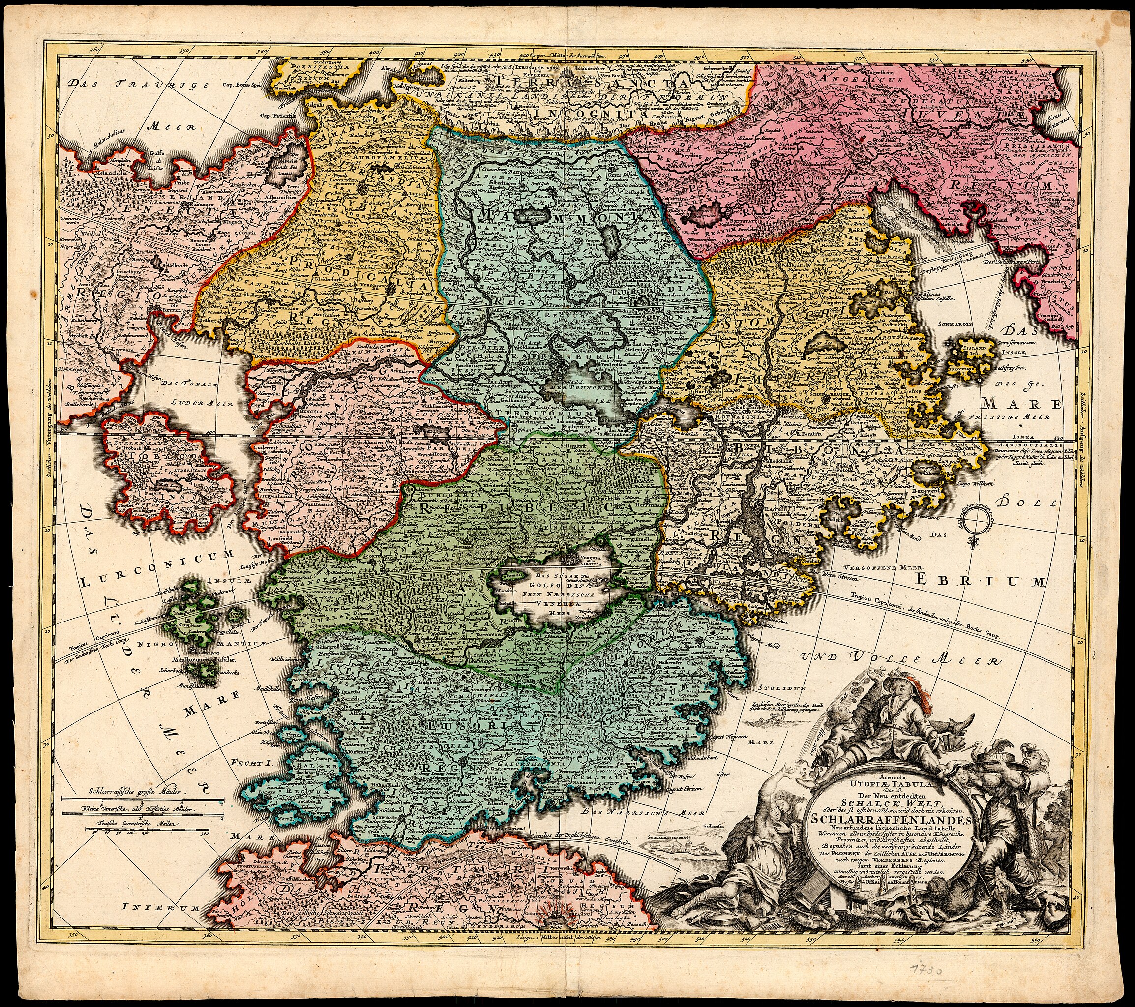
File:Accurata Utopiae Tabula (FL173085858 3423220).jpg

Size of this preview: 676 × 600 pixels. Other resolutions: 270 × 240 pixels | 541 × 480 pixels | 865 × 768 pixels | 1,154 × 1,024 pixels | 2,308 × 2,048 pixels | 14,542 × 12,906 pixels.
Original file (14,542 × 12,906 pixels, file size: 231.2 MB, MIME type: image/jpeg)
Captions
Captions
Add a one-line explanation of what this file represents
Summary
edit| Accurata Utopiae Tabula
( |
||||||||||||||||||||||||
|---|---|---|---|---|---|---|---|---|---|---|---|---|---|---|---|---|---|---|---|---|---|---|---|---|
| Artist |
| |||||||||||||||||||||||
| Contributors | Homann, Johann Baptist, 1663-1724 | |||||||||||||||||||||||
| Title |
Accurata Utopiae Tabula |
|||||||||||||||||||||||
| Publisher |
Officina Homanniana |
|||||||||||||||||||||||
| Description |
Accurata Utopiae Tabula : Das ist Der Neu-entdeckten Schalck-Welt oder des so offt benannten, und doch nie erkannten Schlaraffenlandes Neu-erfundene lächerliche Land-Tabell Worinnen all und jede Laster in besondere Königreich, Provintzien und Herrschafften abgetheilet Beyneben auch die nächst angräntzende Länder der Frommen, des Zeitlichen Auff- u. Unterg. auch ewigen Verderbens Regionen. durch Author. anonymus. |
|||||||||||||||||||||||
| Language | German | |||||||||||||||||||||||
| Publication date | 1720 possibly | |||||||||||||||||||||||
| Medium | 1 map : col ; | |||||||||||||||||||||||
| Dimensions | 49 × 57 cm (19.2 × 22.4 in) | |||||||||||||||||||||||
| Collection |
|
|||||||||||||||||||||||
| Current location |
|
|||||||||||||||||||||||
| Place of publication | Nuremberg | |||||||||||||||||||||||
| Notes | 1 inset: Schlarraffenburg. | |||||||||||||||||||||||
| IE PID | IE173085856 | |||||||||||||||||||||||
| Rosetta filename | FL173085858 | |||||||||||||||||||||||
| NNL item ID (P3959) | 990034232200205171 | |||||||||||||||||||||||
| search Merhav catalog | German, Nuremberg | |||||||||||||||||||||||
| search Merhav catalog | Geographical mythsIImaginary placesMapsOfficina Homanniana | |||||||||||||||||||||||
| Source/Photographer |
|
|||||||||||||||||||||||
| Other versions | ||||||||||||||||||||||||
| Jpg / Tif version |
|
|||||||||||||||||||||||

.jpg)

.jpg&action=edit§ion=1)
Licensing
edit.jpg&action=edit§ion=2)
The copyright situation of this work is theoretically uncertain, because in the country of origin copyright lasts 70 years after the death of the author, and the date of the author's death is unknown. However, the date of creation of the work was over 120 years ago, and it is thus a reasonable assumption that the copyright has expired (see here for the community discussion). Do not use this template if the date of death of the author is known.
| |
| This file has been identified as being free of known restrictions under copyright law, including all related and neighboring rights. | |
File history
Click on a date/time to view the file as it appeared at that time.
| Date/Time | Thumbnail | Dimensions | User | Comment | |
|---|---|---|---|---|---|
| current | 16:58, 15 August 2023 | | 14,542 × 12,906 (231.2 MB) | Geagea (talk | contribs) | pattypan 22.03 |
You cannot overwrite this file.
File usage on Commons
The following page uses this file:
.jpg&oldid=809620034)