File:Aconcagua-Amarillo-Juncal.jpg

Size of this preview: 800 × 533 pixels. Other resolutions: 320 × 213 pixels | 640 × 427 pixels | 1,024 × 683 pixels | 1,280 × 853 pixels | 2,560 × 1,707 pixels | 3,648 × 2,432 pixels.
Original file (3,648 × 2,432 pixels, file size: 1.47 MB, MIME type: image/jpeg)
Captions
Captions
Add a one-line explanation of what this file represents
Summary
edit
| Description |
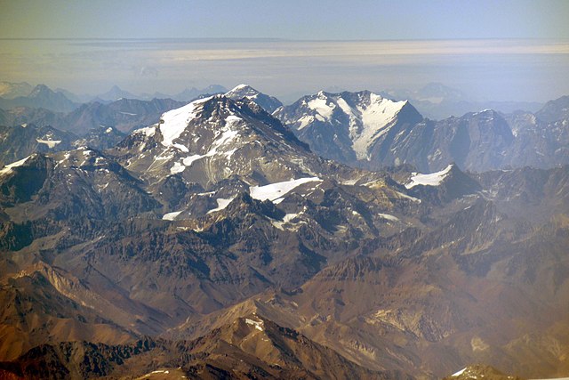
Español: La Cordillera Frontal de la Provincia de San Juan y la Cordillera Principal de la Provincia Mendoza, en la aproximación (aprox. 8900 m s.n.m., aprox. 830 km/h) a Santiago de Chile, 21 minutos antes del aterrizaje: Cerro Amarillo (4790 m s.n.m., distancia 78 km) del Cordón Espinacito en el centro abajo, Cerro Aconcagua (6961 m s.n.m., distancia 117 km), Cerro Nevado Juncal (5953 m s.n.m., distancia 161 km), la cima del Cerro Nevado del Plomo (6070 m s.n.m., distancia 168 km) encima del Aconcagua.
Deutsch: Die Anden-Frontkordillere in der Provinz San Juan und die Hauptkordillere in der Provinz Mondoza, beim Landeanflug (ca. 8900 m ü.M., ca. 830 km/h) auf Santiago de Chile, 21 Minuten vor der Landung: Cerro Amarillo (4790 m ü.M., Entfernung 78 km) des Cordón Espinacito in der Mitte unten, Cerro Aconcagua (6961 m ü.M., Entfernung 117 km), Cerro Nevado Juncal (5953 ü.M., Entfernung 161 km), der Gipfel des Cerro Nevado del Plomo (6070 m ü.M, Entfernung 168 km) über dem Aconcagua. |
| Date | 3 December 2021, 09:48:36 (according to Exif data) |
| Source | Own work |
| Author | WeHaKa |
| Permission (Reusing this file) |
This file is licensed under the Creative Commons Attribution-Share Alike 4.0 International license. Attribution: WeHaKa
|
| Camera location | | View this and other nearby images on: OpenStreetMap |
|---|
| Object location | | View this and other nearby images on: OpenStreetMap |
|---|
| Object location | | View this and other nearby images on: OpenStreetMap |
|---|
| Object location | | View this and other nearby images on: OpenStreetMap |
|---|
| Object location | | View this and other nearby images on: OpenStreetMap |
|---|
| Annotations | This image is annotated: View the annotations at Commons |
File history
Click on a date/time to view the file as it appeared at that time.
| Date/Time | Thumbnail | Dimensions | User | Comment | |
|---|---|---|---|---|---|
| current | 15:52, 14 May 2022 | | 3,648 × 2,432 (1.47 MB) | WeHaKa (talk | contribs) | {{Information |description = {{es| La Cordillera Frontal de la Provincia de San Juan y la Cordillera Principal de la Provincia Mendoza, en la aproximación (aprox. 8900 m s.n.m., aprox. 830 km/h) a Santiago de Chile, 21 minutos antes del aterrizaje: Cerro Amarillo (4790 m s.n.m., distancia 78 km) del Cordón Espinacito en el centro abajo, Cerro Aconcagua (6961 m s.n.m., distancia 117 km), Cerro Nevado Juncal (5953 m s.n.m., distancia 161 km), la cima del Cerro Nevado del Plomo (6070 m s.n.... |
You cannot overwrite this file.
File usage on Commons
There are no pages that use this file.