File:Adaptation du profil topographique au niveau de base par incision des rivières.png
Size of this preview: 800 × 343 pixels. Other resolutions: 320 × 137 pixels | 1,013 × 434 pixels.
Original file (1,013 × 434 pixels, file size: 219 KB, MIME type: image/png)
Captions
Captions
Add a one-line explanation of what this file represents
Summary
edit
| Description |
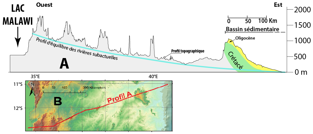
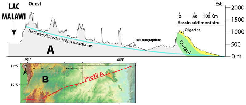
Français : Lors de la surrection d'un relief (ici le Nord-Mozambique) les rivières incisent des vallées afin de s'adapter au niveau de base. Ces incisions s'inscrivrent sur le "profil d'équilibre des rivières" qui va tendre à se confondre avec le niveau de base au fur et à mesure de l'érosion des reliefs. Ici le niveau de base étant le niveau marin, il constitue un plan horizontal d'altitude 0. |
| Date | |
| Source | Own work |
| Author | ManuRoquette |
Licensing
edit
I, the copyright holder of this work, hereby publish it under the following license:
This file is licensed under the Creative Commons Attribution-Share Alike 4.0 International license.
- You are free:
- to share – to copy, distribute and transmit the work
- to remix – to adapt the work
- Under the following conditions:
- attribution – You must give appropriate credit, provide a link to the license, and indicate if changes were made. You may do so in any reasonable manner, but not in any way that suggests the licensor endorses you or your use.
- share alike – If you remix, transform, or build upon the material, you must distribute your contributions under the same or compatible license as the original.
File history
Click on a date/time to view the file as it appeared at that time.
| Date/Time | Thumbnail | Dimensions | User | Comment | |
|---|---|---|---|---|---|
| current | 12:15, 27 June 2016 | | 1,013 × 434 (219 KB) | ManuRoquette (talk | contribs) | Cross-wiki upload from fr.wikipedia.org |
You cannot overwrite this file.
File usage on Commons
There are no pages that use this file.
File usage on other wikis
The following other wikis use this file:
- Usage on fr.wikipedia.org
- Usage on it.wikipedia.org
- Usage on it.wikiversity.org