File:Adlai Osborne Map 1808 original.tif

Size of this JPG preview of this TIF file: 700 × 600 pixels. Other resolutions: 280 × 240 pixels | 560 × 480 pixels | 838 × 718 pixels.
Original file (838 × 718 pixels, file size: 1.7 MB, MIME type: image/tiff)
Captions
Captions
Area where Col Adlai Osborne lived in Iredell County in 1808
Summary edit
| Description |
English: area where Col Adlai Osborne lived in Iredell County, North Carolina in 1807 based on Price and Strothers map printed in 1808 |
| Date | |
| Source |
digital cut and paste from First Actual Survey of the State of North Carolina…,” Jonathan Price and John Strother (surveyors), W.H. Harrison (engraver), C.P. Harrison (printer), 1807, Philadelphia, PA. Ink on paper; HOA: 72 cm, WOA: 152 cm. Library of Congress, Geography and Map Division, Washington, DC, G3900 1808 .P7 Vault. Online: https://www.loc.gov/item/2011593508/ |
| Author | Price and Strother map, digital cut and paste by me |
Licensing edit
|
This work is in the public domain in its country of origin and other countries and areas where the copyright term is the author's life plus 70 years or fewer. This work is in the public domain in the United States because it was published (or registered with the U.S. Copyright Office) before January 1, 1929. | |
| This file has been identified as being free of known restrictions under copyright law, including all related and neighboring rights. | |
File history
Click on a date/time to view the file as it appeared at that time.
| Date/Time | Thumbnail | Dimensions | User | Comment | |
|---|---|---|---|---|---|
| current | 14:38, 22 July 2019 | 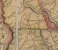 | 838 × 718 (1.7 MB) | G. Moore (talk | contribs) | User created page with UploadWizard |
You cannot overwrite this file.
File usage on Commons
There are no pages that use this file.
File usage on other wikis
The following other wikis use this file:
- Usage on en.wikipedia.org