File:Admiralty Chart No 1824a East Coast of Ireland, Published 1886.jpg

Size of this preview: 323 × 598 pixels. Other resolutions: 129 × 240 pixels | 259 × 480 pixels | 414 × 768 pixels | 552 × 1,024 pixels | 1,105 × 2,048 pixels | 8,391 × 15,548 pixels.
Original file (8,391 × 15,548 pixels, file size: 15.73 MB, MIME type: image/jpeg)
Captions
Captions
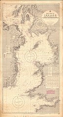
Admiralty Chart No 1824a East Coast of Ireland
Summary
edit
| Warning | The original file is very high-resolution. It might not load properly or could cause your browser to freeze when opened at full size. |
|---|
| Description |
English: Nautical chart covering the East Coast of Ireland with the Irish Sea and the adjacent coasts of western Scotland England and Wales, to a scale of 1/487,000. Engraved 1886, large corrections to 1968. Not current - not to be used for navigation! |
||||||||||
| Date | |||||||||||
| Source | Scan of original Admiralty chart | ||||||||||
| Creator |
|
||||||||||
| Geotemporal data | |||||||||||
| Bounding box |
|
||||||||||
| Georeferencing | |||||||||||
Mercator projection
Licensing
edit
This work created by the United Kingdom Government is in the public domain.
This is because it is one of the following:
HMSO has declared that the expiry of Crown Copyrights applies worldwide (ref: HMSO Email Reply)
|
 |
File history
Click on a date/time to view the file as it appeared at that time.
| Date/Time | Thumbnail | Dimensions | User | Comment | |
|---|---|---|---|---|---|
| current | 11:23, 24 June 2019 | | 8,391 × 15,548 (15.73 MB) | Kognos (talk | contribs) | User created page with UploadWizard |
You cannot overwrite this file.
File usage on Commons
There are no pages that use this file.