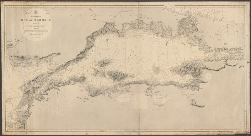
File:Admiralty Chart No 224 Mediterranean. Sea of Marmara - Surveyed by Commander W.J.L. Wharton and the officers of H.M. ships, Shearwater and Fawn 1879-80; engraved by Edwd. Weller, Published 1882.tiff
Size of this JPG preview of this TIF file: 800 × 436 pixels. Other resolutions: 320 × 174 pixels | 640 × 348 pixels | 1,024 × 558 pixels | 1,280 × 697 pixels | 2,560 × 1,394 pixels | 13,257 × 7,218 pixels.
Original file (13,257 × 7,218 pixels, file size: 273.8 MB, MIME type: image/tiff)
Captions
Captions
Mediterranean. Sea of Marmara - Surveyed by Commander W.J.L. Wharton and the officers of H.M. ships, Shearwater and Fawn 1879-80; engraved by Edwd. Weller
Summary edit
| Warning | The original file is very high-resolution. It might not load properly or could cause your browser to freeze when opened at full size. |
|---|
| Description |
English: Mediterranean. Sea of Marmara - Surveyed by Commander W.J.L. Wharton and the officers of H.M. ships, Shearwater and Fawn 1879-80; engraved by Edwd. Weller
Small corrections [to] 1913. |
||||||||||
| Date | |||||||||||
| Source | https://nla.gov.au/nla.obj-231756721/view | ||||||||||
| Creator |
|
||||||||||
| Geotemporal data | |||||||||||
| Bounding box |
|
||||||||||
| Georeferencing | |||||||||||
| Other versions | |||||||||||


Licensing edit
This work created by the United Kingdom Government is in the public domain.
This is because it is one of the following:
HMSO has declared that the expiry of Crown Copyrights applies worldwide (ref: HMSO Email Reply)
|
 |
File history
Click on a date/time to view the file as it appeared at that time.
| Date/Time | Thumbnail | Dimensions | User | Comment | |
|---|---|---|---|---|---|
| current | 14:09, 18 June 2020 |  | 13,257 × 7,218 (273.8 MB) | Balkanique (talk | contribs) | Uploaded a work by Great Britain. Hydrographic Department from https://nla.gov.au/nla.obj-231756721/view with UploadWizard |
You cannot overwrite this file.
File usage on Commons
The following 5 pages use this file:
- File:Kapıdağ Peninsula (cropped).tif
- File:Kapıdağ Peninsula and adjacent islands (cropped).tif
- File:Marmara Island (cropped).tif
- File:Mediterranean. Sea of Marmara - Surveyed by Commander W.J.L. Wharton and the officers of H.M. ships, Shearwater and Fawn 1879-80; engraved by Edwd. Weller.tif (file redirect)
- File:Paşalimanı, Avşa, Koyun, Yer and Ekinlik Islands (cropped).tif