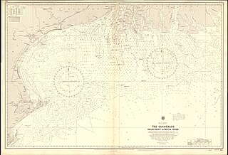
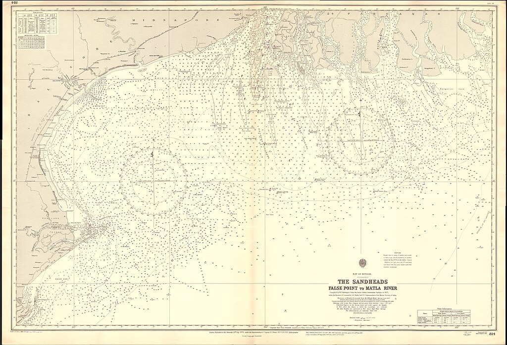
File:Admiralty Chart No 814 The Sandheads False Point to Matla River, Published 1878, Large Corrections 1953.jpg

Size of this preview: 800 × 545 pixels. Other resolutions: 320 × 218 pixels | 640 × 436 pixels | 1,024 × 697 pixels | 1,280 × 871 pixels | 2,560 × 1,742 pixels | 16,314 × 11,104 pixels.
Original file (16,314 × 11,104 pixels, file size: 52.04 MB, MIME type: image/jpeg)
Captions
Captions
Nautical chart from False Point to Matla River
Summary
edit
| Description |
English: Nautical chart of the Sandheads from False Point to Matla River. Not current - not to be used for navigation! |
||||||||||
| Date | |||||||||||
| Source | Scan of original Admiralty Chart | ||||||||||
| Creator |
|
||||||||||
| Geotemporal data | |||||||||||
| Spatial reference system | Mercator | ||||||||||
| Scale | 1:266,400 | ||||||||||
| Bounding box |
|
||||||||||
| Georeferencing | |||||||||||
Licensing
edit
This work created by the United Kingdom Government is in the public domain.
This is because it is one of the following:
HMSO has declared that the expiry of Crown Copyrights applies worldwide (ref: HMSO Email Reply)
|
 |
File history
Click on a date/time to view the file as it appeared at that time.
| Date/Time | Thumbnail | Dimensions | User | Comment | |
|---|---|---|---|---|---|
| current | 17:02, 22 February 2024 | | 16,314 × 11,104 (52.04 MB) | Kognos (talk | contribs) | Uploaded a work by {{Creator:United Kingdom Hydrographic Office}} from Scan of original Admiralty Chart with UploadWizard |
You cannot overwrite this file.
File usage on Commons
There are no pages that use this file.