File:Aerial photo of Peel Monument overlooking Holcombe and Bury.jpg
![File:Aerial photo of Peel Monument overlooking Holcombe and Bury.jpg](https://upload.wikimedia.org/wikipedia/commons/thumb/d/d2/Aerial_photo_of_Peel_Monument_overlooking_Holcombe_and_Bury.jpg/800px-Aerial_photo_of_Peel_Monument_overlooking_Holcombe_and_Bury.jpg?20160930211313)
Original file (3,808 × 2,074 pixels, file size: 5.26 MB, MIME type: image/jpeg)
Captions
Captions
Summary
editDescriptionAerial photo of Peel Monument overlooking Holcombe and Bury.jpg |
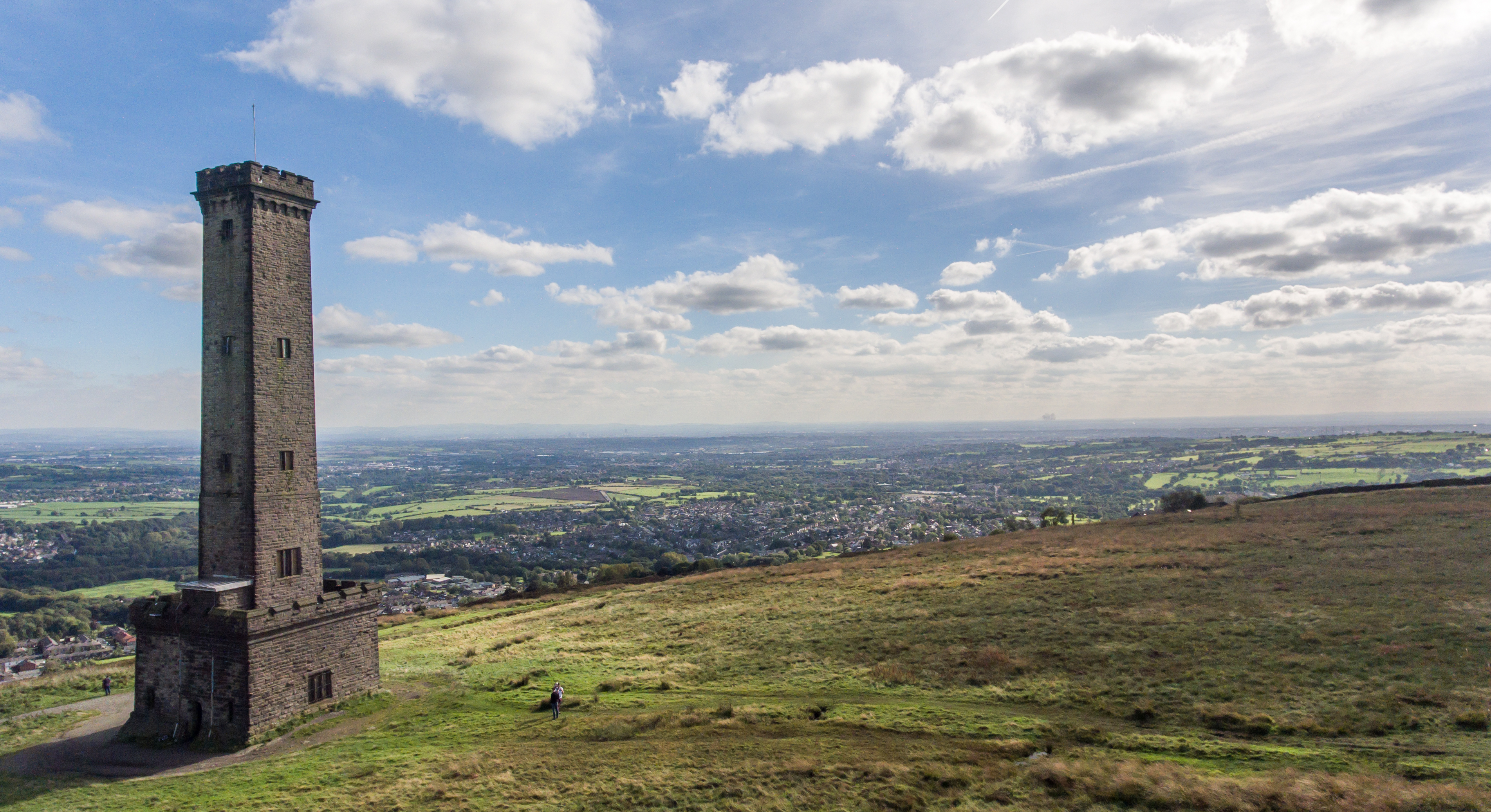
English: Peel Monument
|
||
Date | |||
Source | Own work | ||
Author | Simon Child |
Camera location | 53° 38′ 37.91″ N, 2° 20′ 18.99″ W ![]() | View this and other nearby images on: OpenStreetMap | ![]() |
---|
Peel Monument is on Harcles Hill, overlooking Holcombe and Greenmount. In the middle distance is the town of Bury, birthplace of Sir Robert Peel who founded the modern police force (hence police became known as 'Bobbies', or in Ireland as 'Peelers'). In the far distance is the city of Manchester.
Licensing
edit![w:en:Creative Commons](https://upload.wikimedia.org/wikipedia/commons/thumb/7/79/CC_some_rights_reserved.svg/90px-CC_some_rights_reserved.svg.png)
![attribution](https://upload.wikimedia.org/wikipedia/commons/thumb/1/11/Cc-by_new_white.svg/24px-Cc-by_new_white.svg.png)
![share alike](https://upload.wikimedia.org/wikipedia/commons/thumb/d/df/Cc-sa_white.svg/24px-Cc-sa_white.svg.png)
- You are free:
- to share – to copy, distribute and transmit the work
- to remix – to adapt the work
- Under the following conditions:
- attribution – You must give appropriate credit, provide a link to the license, and indicate if changes were made. You may do so in any reasonable manner, but not in any way that suggests the licensor endorses you or your use.
- share alike – If you remix, transform, or build upon the material, you must distribute your contributions under the same or compatible license as the original.
![]() |
This image was uploaded as part of Wiki Loves Monuments 2016.
Afrikaans ∙ Alemannisch ∙ العربية ∙ جازايرية ∙ azərbaycanca ∙ Bikol Central ∙ беларуская ∙ беларуская (тарашкевіца) ∙ български ∙ বাংলা ∙ brezhoneg ∙ bosanski ∙ català ∙ čeština ∙ Cymraeg ∙ dansk ∙ Deutsch ∙ Zazaki ∙ Ελληνικά ∙ English ∙ Esperanto ∙ español ∙ eesti ∙ euskara ∙ فارسی ∙ suomi ∙ français ∙ Frysk ∙ Gaeilge ∙ galego ∙ עברית ∙ हिन्दी ∙ hrvatski ∙ magyar ∙ հայերեն ∙ Bahasa Indonesia ∙ Ido ∙ italiano ∙ 日本語 ∙ ქართული ∙ 한국어 ∙ кыргызча ∙ Lëtzebuergesch ∙ latviešu ∙ Malagasy ∙ македонски ∙ മലയാളം ∙ Bahasa Melayu ∙ Malti ∙ norsk bokmål ∙ नेपाली ∙ Nederlands ∙ norsk nynorsk ∙ norsk ∙ polski ∙ português ∙ português do Brasil ∙ română ∙ русский ∙ sicilianu ∙ davvisámegiella ∙ slovenčina ∙ slovenščina ∙ shqip ∙ српски / srpski ∙ svenska ∙ ไทย ∙ Tagalog ∙ Türkçe ∙ українська ∙ اردو ∙ Yorùbá ∙ 中文 ∙ 中文(中国大陆) ∙ 中文(简体) ∙ 中文(繁體) ∙ 中文(香港) ∙ 中文(臺灣) ∙ +/− |
![]() |
File history
Click on a date/time to view the file as it appeared at that time.
Date/Time | Thumbnail | Dimensions | User | Comment | |
---|---|---|---|---|---|
current | 21:13, 30 September 2016 | ![]() | 3,808 × 2,074 (5.26 MB) | Simon Child (talk | contribs) | User created page with UploadWizard |
You cannot overwrite this file.
File usage on Commons
There are no pages that use this file.
File usage on other wikis
The following other wikis use this file:
- Usage on en.wikipedia.org
Metadata
This file contains additional information such as Exif metadata which may have been added by the digital camera, scanner, or software program used to create or digitize it. If the file has been modified from its original state, some details such as the timestamp may not fully reflect those of the original file. The timestamp is only as accurate as the clock in the camera, and it may be completely wrong.
Camera manufacturer | DJI |
---|---|
Camera model | FC330 |
Exposure time | 1/1,400 sec (0.00071428571428571) |
F-number | f/2.8 |
ISO speed rating | 100 |
Date and time of data generation | 14:53, 22 September 2016 |
Lens focal length | 3.61 mm |
Latitude | 53° 38′ 37.91″ N |
Longitude | 2° 20′ 18.99″ W |
Altitude | 327.337 meters above sea level |
Orientation | Normal |
Horizontal resolution | 300 dpi |
Vertical resolution | 300 dpi |
Software used | Adobe Photoshop Elements 12.0 Windows |
File change date and time | 21:55, 30 September 2016 |
Exposure Program | 58655 |
Exif version | 2.3 |
Date and time of digitizing | 14:53, 22 September 2016 |
APEX shutter speed | 10.451211 |
APEX aperture | 2.970854 |
APEX exposure bias | −1.3125 |
Maximum land aperture | 2.97 APEX (f/2.8) |
Subject distance | 0 meters |
Metering mode | Center weighted average |
Light source | Unknown |
Flash | Flash did not fire, No flash function |
Color space | sRGB |
File source | Digital still camera |
Scene type | A directly photographed image |
Custom image processing | Normal process |
Exposure mode | Auto bracket |
White balance | Auto white balance |
Digital zoom ratio | 0 |
Focal length in 35 mm film | 20 mm |
Scene capture type | Standard |
Scene control | None |
Contrast | Normal |
Saturation | Normal |
Sharpness | Normal |
Subject distance range | Unknown |
GPS tag version | 0.0.3.2 |
Serial number of camera | ff07ffff16ff73ff4bffffffff352e61 |
Lens used | 3.6 mm |
Rating (out of 5) | 0 |
Date metadata was last modified | 22:55, 30 September 2016 |
Unique ID of original document | E9C93681D37318AB2953540AA2C4DCC4 |