File:Aerial view of State Route 315 and Franklinton looking Northwest - DPLA - 0d7fecc89d1f77318f4571a0495a35b7 (page 1).jpg

Size of this preview: 484 × 600 pixels. Other resolutions: 194 × 240 pixels | 387 × 480 pixels | 620 × 768 pixels | 827 × 1,024 pixels | 1,653 × 2,048 pixels | 4,818 × 5,968 pixels.
Original file (4,818 × 5,968 pixels, file size: 5.47 MB, MIME type: image/jpeg)
Captions
Captions
Add a one-line explanation of what this file represents
Summary
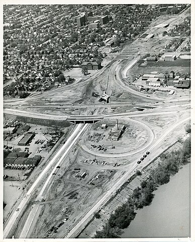
edit| Aerial view of State Route 315 and Franklinton looking Northwest
( |
||||||||||||||||||
|---|---|---|---|---|---|---|---|---|---|---|---|---|---|---|---|---|---|---|
| Creator | ||||||||||||||||||
| Title |
Aerial view of State Route 315 and Franklinton looking Northwest |
|||||||||||||||||
| Description |
An aerial view looking northwest at Franklinton near Interstate 70. The bottom half of the photograph features the construction of State Route 315. The Bellows School, 725 Bellows Ave, Columbus, OH, and Mount Carmel West Hospital, 120 South Green Street, Columbus, OH, can be seen center, upper portion of the picture. |
|||||||||||||||||
| Collection |
|
|||||||||||||||||
| Source/Photographer |
|
|||||||||||||||||
| Permission (Reusing this file) |
Copyright determination made by Columbus Metropolitan Library ( Q69487420) using RightsStatements.org
|
|||||||||||||||||


.jpg&action=edit§ion=1)
File history
Click on a date/time to view the file as it appeared at that time.
| Date/Time | Thumbnail | Dimensions | User | Comment | |
|---|---|---|---|---|---|
| current | 12:00, 29 July 2023 | | 4,818 × 5,968 (5.47 MB) | DPLA bot (talk | contribs) | Uploading DPLA ID "0d7fecc89d1f77318f4571a0495a35b7". |
You cannot overwrite this file.
File usage on Commons
The following page uses this file:
.jpg)
.jpg&oldid=798595437)