File:Afar Triangle's Lake Afrera.jpg

Size of this preview: 800 × 531 pixels. Other resolutions: 320 × 212 pixels | 640 × 425 pixels | 1,024 × 679 pixels | 1,280 × 849 pixels | 2,560 × 1,699 pixels | 8,000 × 5,308 pixels.
Original file (8,000 × 5,308 pixels, file size: 42.79 MB, MIME type: image/jpeg)
Captions
Captions
Sentinel 2 satellite image
Summary edit
| Description |
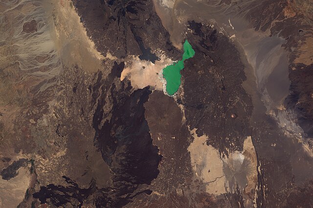
English: The hypersaline lake Afrera and the salt mines that cradle its shores in the northern part of the Afar Triangle in Ethiopia. This image is a composite of visible light bands from Sentinel-2 satellite courtesy Copernicus EU Earth observation programme. Captured on April 8, 2020. |
| Date | |
| Source | https://www.flickr.com/photos/187916110@N02/49771522858/ |
| Author | Yonas Kidane |
Licensing edit
This file is licensed under the Creative Commons Attribution 2.0 Generic license.
- You are free:
- to share – to copy, distribute and transmit the work
- to remix – to adapt the work
- Under the following conditions:
- attribution – You must give appropriate credit, provide a link to the license, and indicate if changes were made. You may do so in any reasonable manner, but not in any way that suggests the licensor endorses you or your use.
| This image was originally posted to Flickr by Yonas Kidane at https://flickr.com/photos/187916110@N02/49771522858. It was reviewed on 25 October 2020 by FlickreviewR 2 and was confirmed to be licensed under the terms of the cc-by-2.0. |
File history
Click on a date/time to view the file as it appeared at that time.
| Date/Time | Thumbnail | Dimensions | User | Comment | |
|---|---|---|---|---|---|
| current | 08:40, 25 October 2020 | | 8,000 × 5,308 (42.79 MB) | Kroger4 (talk | contribs) | Uploaded a work by Yonas Kidane from https://www.flickr.com/photos/187916110@N02/49771522858/ with UploadWizard |
You cannot overwrite this file.
File usage on Commons
There are no pages that use this file.
File usage on other wikis
The following other wikis use this file:
- Usage on de.wikipedia.org