File:Africa1898.png
Original file (2,490 × 3,563 pixels, file size: 4.14 MB, MIME type: image/png)
Captions
Captions
Summary
edit
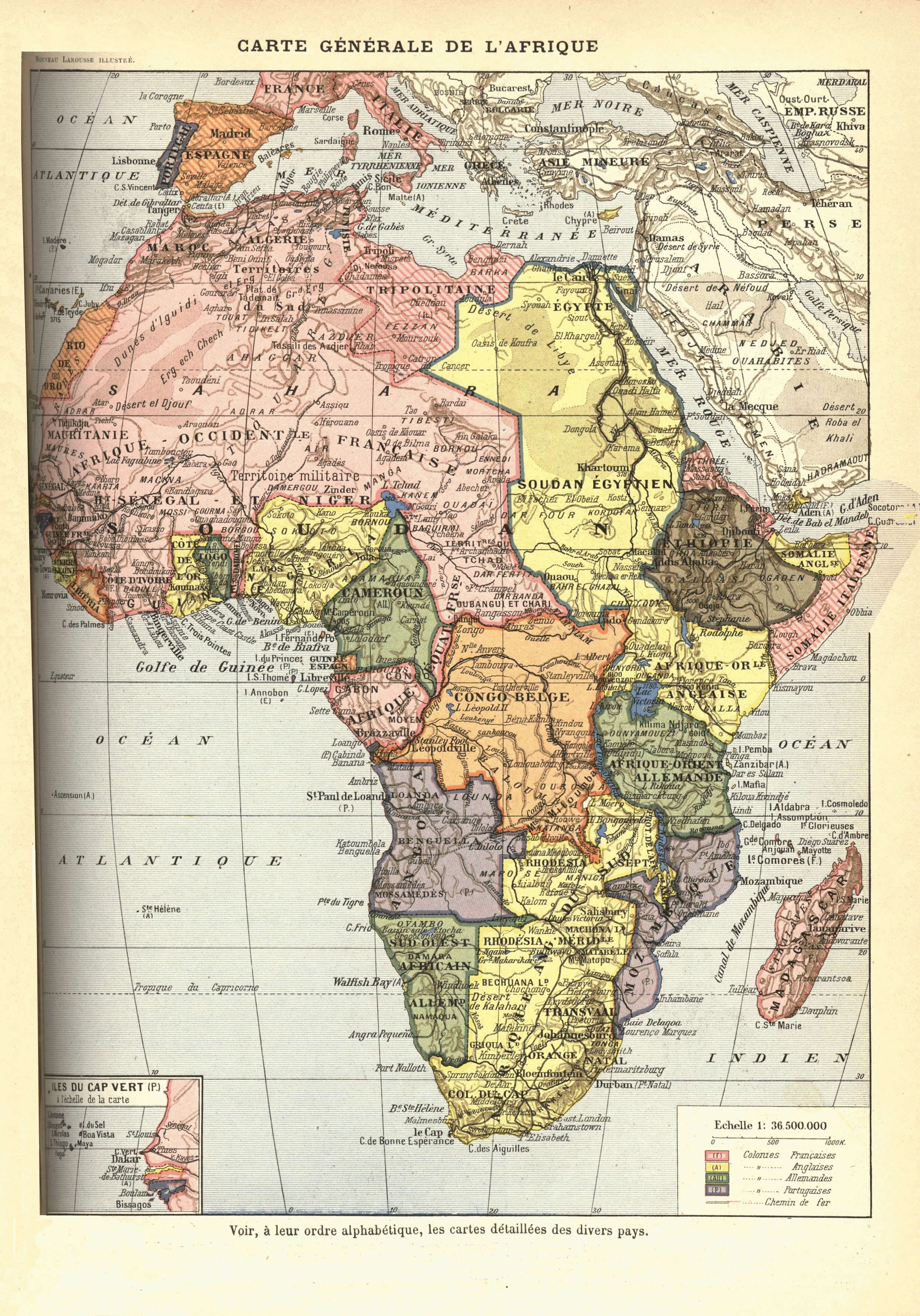
French map of Africa from 1912? [text in comment below says 1898], originally published as "Carte Générale de l'Afrique : Voir, à leur ordre alphabétique, les cartes detaillées des divers pays" in Nouveau Larousse illustré ; dictionnaire universel encyclopédique, publié sous la direction de Claude Augé. Paris, Librairie Larousse. 1898-1904. Original scan available at http://www.lib.msu.edu/coll/main/maps/mapscan/AFthumbs.html
Colonial claims:
- British possessions are in yellow
- French possessions in pink
- Belgian in orange
- German in green
- Portuguese in purple
- Italian in striped pink
- Spanish in striped orange
- independent Ethiopia in brown
Note:
This map is depicts various anachronisms and despite the stated publication date above (different editions?) of its work, was drawn between 1911 and 1914:
- en:Belgian Congo includes the en:Lado enclave, which was ceded to Anglo-Sudan in 1910.
- Occupation of Libya by Italy started in 1911, and the colony was established in 1912.
- "Cameroun" is depicted with the territory of German en:Neukamerun, ceded from France 1911.
Licensing
edit
|
This work is in the public domain in its country of origin and other countries and areas where the copyright term is the author's life plus 70 years or fewer.
| |
| This file has been identified as being free of known restrictions under copyright law, including all related and neighboring rights. | |
File history
Click on a date/time to view the file as it appeared at that time.
| Date/Time | Thumbnail | Dimensions | User | Comment | |
|---|---|---|---|---|---|
| current | 16:27, 16 July 2009 | | 2,490 × 3,563 (4.14 MB) | Jonverve~commonswiki (talk | contribs) | update - rotate and fix |
| 19:49, 11 May 2006 |  | 962 × 1,314 (915 KB) | Kmusser (talk | contribs) | French map of Africa from 1898, originally published as "Carte Generale de l'Afrique: Voir, a leur orde alphabetique, les cartes detaillees des divers pays" in Nouveau Larousse illustré; dictionnaire universel encyclopédique, publié sous la direction d |
You cannot overwrite this file.
File usage on Commons
The following page uses this file:
File usage on other wikis
The following other wikis use this file:
- Usage on ast.wikipedia.org
- Usage on az.wikipedia.org
- Usage on ba.wikipedia.org
- Usage on be.wikipedia.org
- Usage on bg.wikipedia.org
- Usage on da.wikipedia.org
- Usage on en.wikiversity.org
- Usage on es.wikipedia.org
- Usage on fr.wikipedia.org
- Usage on he.wikipedia.org
- Usage on hu.wikipedia.org
- Usage on hy.wikipedia.org
- Usage on is.wikipedia.org
- Usage on it.wikipedia.org
- Usage on ja.wikipedia.org
- Usage on mk.wikipedia.org
- Usage on mwl.wikipedia.org
- Usage on nl.wikipedia.org
- Usage on oc.wikipedia.org
- Usage on pl.wikipedia.org
- Usage on pt.wikipedia.org
- História da África
- História da Guiné-Bissau
- História da Libéria
- História da Nigéria
- História do Congo
- História de Burquina Fasso
- História de Moçambique
- História da Etiópia
- História do Gabão
- História da Líbia
- História de Marrocos
- História do Quênia
- História do Gana
- História da África do Sul
- História da Costa do Marfim
- História da Tunísia
- História do Sudão
- História do Ruanda
- História do Togo
- História de Cabo Verde
View more global usage of this file.