File:Afrique-Agathocle-es.svg

Size of this PNG preview of this SVG file: 800 × 600 pixels. Other resolutions: 320 × 240 pixels | 640 × 480 pixels | 1,024 × 768 pixels | 1,280 × 960 pixels | 2,560 × 1,919 pixels | 2,812 × 2,108 pixels.
Original file (SVG file, nominally 2,812 × 2,108 pixels, file size: 797 KB)
Captions
Captions
Add a one-line explanation of what this file represents
Summary
edit
| Description |
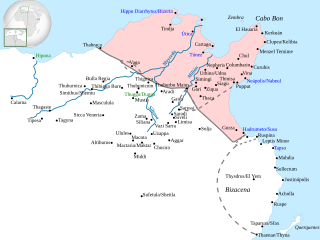
Español: Mapa de los territorios cartagineses en África en el que aparecen marcadas las poblaciones conquistadas por Agatocles (en azul) y las que probablemente tomó Eumaco (en verde). |
| Date | |
| Source |
This file was derived from: Afrique-Agathocle.jpg |
| Author |
Afrique-Agathocle.jpg: Sandrine Crouzet
|
Licensing
edit
This file is licensed under the Creative Commons Attribution-Share Alike 3.0 Unported license.
- You are free:
- to share – to copy, distribute and transmit the work
- to remix – to adapt the work
- Under the following conditions:
- attribution – You must give appropriate credit, provide a link to the license, and indicate if changes were made. You may do so in any reasonable manner, but not in any way that suggests the licensor endorses you or your use.
- share alike – If you remix, transform, or build upon the material, you must distribute your contributions under the same or compatible license as the original.
File history
Click on a date/time to view the file as it appeared at that time.
| Date/Time | Thumbnail | Dimensions | User | Comment | |
|---|---|---|---|---|---|
| current | 09:21, 23 October 2021 | | 2,812 × 2,108 (797 KB) | Rowanwindwhistler (talk | contribs) | Uploaded a work by Sandrine Crouzet from https://commons.wikimedia.org/wiki/File:Afrique-Agathocle.jpg with UploadWizard |
You cannot overwrite this file.
File usage on Commons
The following page uses this file:
File usage on other wikis
The following other wikis use this file:
- Usage on es.wikipedia.org