File:After Effects (25727393810).jpg

Original file (3,483 × 2,281 pixels, file size: 1.02 MB, MIME type: image/jpeg)
Captions
Captions
Summary
edit.jpg&action=edit§ion=1)
| Description |
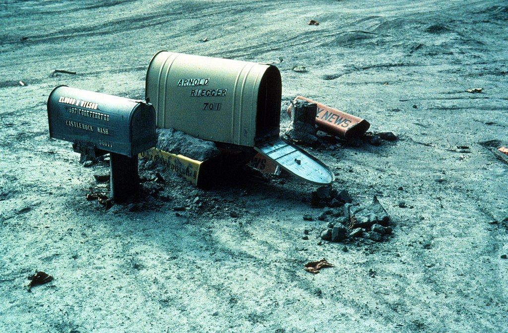
The May 18, 1980 eruption of Mount St. Helens is one that will live forever in modern history. At 8:32am on that day, a magnitude 5.1 occurred and was accompanied by a rapid series of events. At the same time as the earthquake, the volcano's northern bulge and summit slid away as a huge landslide—the largest debris avalanche on Earth in recorded history. A small, dark, ash-rich eruption plume rose directly from the base of the debris avalanche scarp, and another from the summit crater rose to about 200 m (650 ft) high. The debris avalanche swept around and up ridges to the north, but most of it turned westward as far as 23 km (14 mi) down the valley of the North Fork Toutle River and formed a hummocky deposit. The total avalanche volume was about 2.5 km3 (3.3 billion cubic yards), equivalent to 1 million Olympic swimming pools. You can learn more about the history of eruptions at Mount St. Helens at on.doi.gov/HelensHistory. Don't forget to follow USGS Volcanoes as well to learn more about volcano research at the USGS. This photo was taken on July 15, 1980 which shows the after-effects of this major event. Here we see mudflow almost to the top of the mailbox posts near Cowlitz River in Cowlitz County, Washington. Photo credit: Lyn Topinka. |
| Date | |
| Source | After Effects |
| Author | U.S. Geological Survey from Reston, VA, USA |
Licensing
edit.jpg&action=edit§ion=2)
| This image was originally posted to Flickr by U.S. Geological Survey at https://flickr.com/photos/27784370@N05/25727393810 (archive). It was reviewed on 19 January 2018 by FlickreviewR 2 and was confirmed to be licensed under the terms of the Public Domain Mark. |
This image is in the public domain in the United States because it only contains materials that originally came from the United States Geological Survey, an agency of the United States Department of the Interior. For more information, see the official USGS copyright policy.
|
File history
Click on a date/time to view the file as it appeared at that time.
| Date/Time | Thumbnail | Dimensions | User | Comment | |
|---|---|---|---|---|---|
| current | 21:00, 19 January 2018 | | 3,483 × 2,281 (1.02 MB) | Artix Kreiger 2 (talk | contribs) | Transferred from Flickr via Flickr2Commons |
You cannot overwrite this file.
File usage on Commons
There are no pages that use this file.
File usage on other wikis
The following other wikis use this file:
- Usage on en.wikipedia.org
.jpg&oldid=807761079)