File:AgadezMNJattacks0807.png
AgadezMNJattacks0807.png (363 × 300 pixels, file size: 105 KB, MIME type: image/png)
Captions
Captions
Summary edit
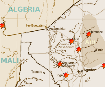
| Description | Map of the summer 2007 fighting between the tuareg insugenciey and government forces in the northwest of Niger | |||
| Date | ||||
| Source |
Highly adapted using the Gimp from http://www.un.org/Depts/Cartographic/map/profile/niger.pdf
|
|||
| Author | T L Miles |
Highly adapted from http://www.un.org/Depts/Cartographic/map/profile/niger.pdf
| This image is a map derived from a United Nations map.
Unless stated otherwise, UN maps are to be considered in the public domain. This applies worldwide. UN maps are, in principle, open source material and you can use them in your work or for making your own map. UN requests however that you delete the UN name, logo and reference number upon any modification to the map. Content of your map will be your responsibility. You can state in your publication, if you wish, something like: based on UN map … (map name, map number, revision number and date). See: Geospatial Information Section. And: Geospatial, location data for a better world. |
 |
Licensing edit
| I, the copyright holder of this work, release this work into the public domain. This applies worldwide. In some countries this may not be legally possible; if so: I grant anyone the right to use this work for any purpose, without any conditions, unless such conditions are required by law. |
File history
Click on a date/time to view the file as it appeared at that time.
| Date/Time | Thumbnail | Dimensions | User | Comment | |
|---|---|---|---|---|---|
| current | 19:13, 30 August 2007 | | 363 × 300 (105 KB) | T L Miles (talk | contribs) | {{Information |Description= Map of the summer 2007 fighting between the tuareg insugenciey and government forces in the northwest of Niger |Source=Highly adapted using the Gimp from http://www.un.org/Depts/Cartographic/map/profile/niger.pdf {{UN map}} |
You cannot overwrite this file.
File usage on Commons
The following page uses this file:
File usage on other wikis
The following other wikis use this file:
- Usage on de.wikipedia.org
- Usage on en.wikipedia.org
- Usage on es.wikipedia.org
- Usage on fi.wikipedia.org
- Usage on id.wikipedia.org
- Usage on pt.wikipedia.org
- Usage on sv.wikipedia.org
- Usage on www.wikidata.org