File:Agni-III Ranges.png
No higher resolution available.
Agni-III_Ranges.png (631 × 527 pixels, file size: 32 KB, MIME type: image/png)
Captions
Captions
Add a one-line explanation of what this file represents
Summary
edit
| Description |
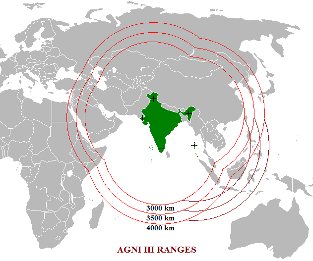
English: This is a map diagram showing indicative ranges for the en:Agni-III Missile. The range of the Agni III is 3000 km, and most probably has the capability of hitting targets over 4000 km.
I created this diagram using [[:en:Image:BlankMap-World.png]] |
| Date | 12 April 2007 (original upload date) |
| Source | Transferred from en.wikipedia to Commons. |
| Author | Sniperz11 at English Wikipedia |
Licensing
edit
| This work has been released into the public domain by its author, Sniperz11 at English Wikipedia. This applies worldwide. In some countries this may not be legally possible; if so: Sniperz11 grants anyone the right to use this work for any purpose, without any conditions, unless such conditions are required by law. |
Original upload log
edit
The original description page was here. All following user names refer to en.wikipedia.
- 2007-04-12 22:45 Sniperz11 631×527×8 (33270 bytes) This is a map diagram showing indicative ranges for the [[Agni-III]] Missile. The range of the Agni III is 3000 km, and most probably has the capability of hitting targets over 4000 km. I created this diagram using [[Image:BlankMap-World.png]]
File history
Click on a date/time to view the file as it appeared at that time.
| Date/Time | Thumbnail | Dimensions | User | Comment | |
|---|---|---|---|---|---|
| current | 13:51, 12 January 2008 | | 631 × 527 (32 KB) | File Upload Bot (Magnus Manske) (talk | contribs) | {{BotMoveToCommons|en.wikipedia}} {{Information |Description={{en|This is a map diagram showing indicative ranges for the en:Agni-III Missile. The range of the Agni III is 3000 km, and most probably has the capability of hitting targets over 4000 km |
You cannot overwrite this file.
File usage on Commons
There are no pages that use this file.
File usage on other wikis
The following other wikis use this file:
- Usage on de.wikipedia.org
- Usage on en.wikipedia.org
- Usage on id.wikipedia.org
- Usage on ml.wikipedia.org