File:Agrandissement des sacristies de la cathédrale de Laval 1897 - Archives nationales (France).jpg

Size of this preview: 472 × 600 pixels. Other resolutions: 189 × 240 pixels | 378 × 480 pixels | 604 × 768 pixels | 806 × 1,024 pixels | 1,612 × 2,048 pixels | 2,624 × 3,334 pixels.
Original file (2,624 × 3,334 pixels, file size: 876 KB, MIME type: image/jpeg)
Captions
Captions
Add a one-line explanation of what this file represents
Summary
edit| Jean-Camille Formigé: Q64853738
|
||||||||||||||||||||||||
|---|---|---|---|---|---|---|---|---|---|---|---|---|---|---|---|---|---|---|---|---|---|---|---|---|
| Artist |
|
.jpg) | ||||||||||||||||||||||
| Title |
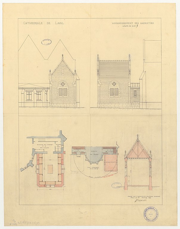
French: Agrandissement des sacristies de la cathédrale de Laval (1897) |
|||||||||||||||||||||||
| Part of |
Sub-series F/19 of the Archives nationales |
|||||||||||||||||||||||
| Object type |
drawing / architectural plan |
|||||||||||||||||||||||
| Description |
"Cathédrale de Laval. Agrandissement des sacristies". Dessin d'architecture issu des dossiers de travaux de restauration des cathédrales (1802-1912), conservés aux Archives nationales (inventaire et autres documents numérisés consultables en ligne). |
|||||||||||||||||||||||
| Date |
25 February 1897 |
|||||||||||||||||||||||
| Medium |
tracing paper, ink, watercolor and wash |
|||||||||||||||||||||||
| Dimensions |
height: 55 cm (21.6 in) |
|||||||||||||||||||||||
| Collection |
|
|||||||||||||||||||||||
| Accession number |
CP/F/19/7720, Plan 4 (Archives nationales) |
|||||||||||||||||||||||
| Object location |
|
|||||||||||||||||||||||
| Place of creation | Laval | |||||||||||||||||||||||
| References |
http://www.siv.archives-nationales.culture.gouv.fr/siv/UD/FRAN_IR_054873/d_78543013 |
|||||||||||||||||||||||
| Source/Photographer |
|
|||||||||||||||||||||||
| Permission (Reusing this file) |
|
|||||||||||||||||||||||


.jpg&action=edit§ion=1)
.jpg¶ms=048.068056_N_-000.773611_E_globe:Earth_class:object_type:object__&language=en)
Licensing
edit.jpg&action=edit§ion=2)
|
This work is in the public domain in its country of origin and other countries and areas where the copyright term is the author's life plus 100 years or fewer. This work is in the public domain in the United States because it was published (or registered with the U.S. Copyright Office) before January 1, 1929. | |
| This file has been identified as being free of known restrictions under copyright law, including all related and neighboring rights. | |
| Object location | | View this and other nearby images on: OpenStreetMap |
|---|
.jpg¶ms=048.068050_N_-000.773550_E_globe:Earth_class:object_type:object__&language=en)
File history
Click on a date/time to view the file as it appeared at that time.
| Date/Time | Thumbnail | Dimensions | User | Comment | |
|---|---|---|---|---|---|
| current | 09:43, 28 June 2019 | | 2,624 × 3,334 (876 KB) | Archives nationales DJI (talk | contribs) | pattypan 19.06 |
You cannot overwrite this file.
File usage on Commons
The following 2 pages use this file:
File usage on other wikis
The following other wikis use this file:
- Usage on www.wikidata.org
.jpg&oldid=786358519)