File:Agricultural Map by Whittlesey, D.S.png

Size of this preview: 800 × 424 pixels. Other resolutions: 320 × 170 pixels | 640 × 339 pixels | 1,179 × 625 pixels.
Original file (1,179 × 625 pixels, file size: 164 KB, MIME type: image/png)
Captions
Captions
Add a one-line explanation of what this file represents
Summary
edit
| Description |
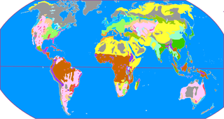
English: This is the map of agricultural area which was proposed by Derwent Stainthorpe Whittlesey, an American geographer. 日本語: アメリカの地理学者・ホイットルセーによる農業地域区分図。 |
| Date | |
| Source | Own work |
| Author | Miyuki Meinaka |
Licensing
edit
I, the copyright holder of this work, hereby publish it under the following license:
This file is licensed under the Creative Commons Attribution-Share Alike 3.0 Unported license.
- You are free:
- to share – to copy, distribute and transmit the work
- to remix – to adapt the work
- Under the following conditions:
- attribution – You must give appropriate credit, provide a link to the license, and indicate if changes were made. You may do so in any reasonable manner, but not in any way that suggests the licensor endorses you or your use.
- share alike – If you remix, transform, or build upon the material, you must distribute your contributions under the same or compatible license as the original.
File history
Click on a date/time to view the file as it appeared at that time.
| Date/Time | Thumbnail | Dimensions | User | Comment | |
|---|---|---|---|---|---|
| current | 03:09, 16 August 2011 | | 1,179 × 625 (164 KB) | Miyuki Meinaka (talk | contribs) |
You cannot overwrite this file.
File usage on Commons
There are no pages that use this file.
File usage on other wikis
The following other wikis use this file:
- Usage on ast.wikipedia.org
- Usage on ca.wikipedia.org
- Usage on es.wikipedia.org
- Usage on ja.wikipedia.org