File:Alaitz-Izko-Lerga-Gerinda-Usua mendilerroak.png

Size of this preview: 464 × 600 pixels. Other resolutions: 186 × 240 pixels | 371 × 480 pixels | 704 × 910 pixels.
Original file (704 × 910 pixels, file size: 1.35 MB, MIME type: image/png)
Captions
Captions
Add a one-line explanation of what this file represents
Summary
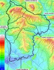
edit| Description |
Euskara: Alaitz, Izko, Lerga, Gerinda eta Uxueko mendilerroen mapa topografikoa.
English: Topographic map showing the Alaitz, Izko, Lerga, Gerinda and Uxue mountain ranges.
Français : Carte topographique des massifs d'Alaitz, Izko, Lerga, Gerinda et Uxue.
Español: Mapa topografico de las sierras de Alaitz, Izko, Lerga, Gerinda y Uxue. |
|||||
| Date | ||||||
| Source |
Own work Map data & imagery © OpenStreetMap Leaflet, an open-source JavaScript library Topographic-map.com, Visualisation et partage de cartes topographiques gratuites. |
|||||
| Author |
|

File history
Click on a date/time to view the file as it appeared at that time.
| Date/Time | Thumbnail | Dimensions | User | Comment | |
|---|---|---|---|---|---|
| current | 00:07, 30 September 2019 | | 704 × 910 (1.35 MB) | Zorion (talk | contribs) | improvement |
| 22:59, 29 September 2019 |  | 704 × 910 (1.35 MB) | Zorion (talk | contribs) | User created page with UploadWizard |
You cannot overwrite this file.
File usage on Commons
The following 2 pages use this file:
File usage on other wikis
The following other wikis use this file:
- Usage on eu.wikipedia.org
- Usage on www.wikidata.org