File:Alb-Limes bei Gerstetten-Gussenstadt.jpg

Original file (2,662 × 4,000 pixels, file size: 6.23 MB, MIME type: image/jpeg)
Captions
Captions
Summary edit
| Description |
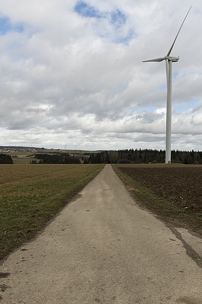
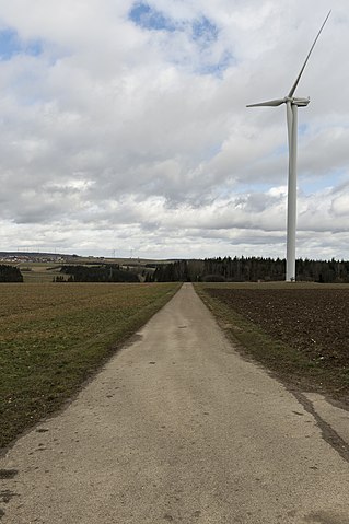
Deutsch: Verlauf des Alb-Limes zwischen Urspring (Ad Lunam) und Heidenheim (Aquileia), 2 km nordwestlich von Gerstetten-Gussenstadt. Der römische Straßenkörper war hier als 0,7 m hohe und 6 m breite Erhöhung sichtbar. Am 5. Oktober 1977 wurde vom Landesdenkmalamt Stuttgart ein Profil der Straße aufgenommen, bevor die Aufschüttung planiert und der heutige Straßenbelag eingebaut wurde. Der Alb-Limes verlief hier Richtung Norden hinunter ins Eseltal, wo er in Richtung Westen nach Heidenheim abbog. Vgl. Stefan Franz Pfahl: „Die römische und frühalamannische Besiedlung zwischen Donau, Brenz und Nau“ Kapitel X: Das Straßennetz, A. Urspring – Heidenheim |
||
| Date | |||
| Source | Own work | ||
| Author | Thilo Parg | ||
| Permission (Reusing this file) |
|
| Camera location | | View this and other nearby images on: OpenStreetMap |
|---|
Licensing edit
- You are free:
- to share – to copy, distribute and transmit the work
- to remix – to adapt the work
- Under the following conditions:
- attribution – You must give appropriate credit, provide a link to the license, and indicate if changes were made. You may do so in any reasonable manner, but not in any way that suggests the licensor endorses you or your use.
- share alike – If you remix, transform, or build upon the material, you must distribute your contributions under the same or compatible license as the original.
File history
Click on a date/time to view the file as it appeared at that time.
| Date/Time | Thumbnail | Dimensions | User | Comment | |
|---|---|---|---|---|---|
| current | 22:14, 15 February 2020 | | 2,662 × 4,000 (6.23 MB) | Thilo Parg (talk | contribs) | {{Information |description ={{de|1=Verlauf des Alb-Limes zwischen Urspring (Ad Lunam) und Heidenheim (Aquileia), 2 km nordwestlich von Gerstetten-Gussenstadt. Der römische Straßenkörper war hier als 0,7 m hohe und. 6 m breite Erhöhung sichtbar. Am 5. Oktober 1977 wurde vom Landesdenkmalamt Stuttgart ein Profil der Straße aufgenommen, bevor die Aufschüttung planiert und der heutige Straßenbelag eingebaut wurde. Die Straße verlief hier Richtung Norden hinunter ins Eselstal, wo sie in Richtun... |
You cannot overwrite this file.
File usage on Commons
The following page uses this file:
File usage on other wikis
The following other wikis use this file:
- Usage on de.wikipedia.org