File:Albania relief location map.jpg

Size of this preview: 410 × 600 pixels. Other resolutions: 164 × 240 pixels | 328 × 480 pixels | 685 × 1,002 pixels.
Original file (685 × 1,002 pixels, file size: 406 KB, MIME type: image/jpeg)
Captions
Captions
Add a one-line explanation of what this file represents
Summary edit
| Description |
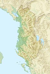
English: Location map of Albania.
Equirectangular projection. Strechted by 130.0%. Geographic limits of the map: * N: 42.9° N * S: 39.3° N * W: 18.3° E * E: 21.5° EMade with Natural Earth. Free vector and raster map data @ naturalearthdata.com. |
| Date | |
| Source | Own work |
| Author | Uwe Dedering |
Licensing edit
I, the copyright holder of this work, hereby publish it under the following licenses:
This file is licensed under the Creative Commons Attribution-Share Alike 3.0 Unported license.
- You are free:
- to share – to copy, distribute and transmit the work
- to remix – to adapt the work
- Under the following conditions:
- attribution – You must give appropriate credit, provide a link to the license, and indicate if changes were made. You may do so in any reasonable manner, but not in any way that suggests the licensor endorses you or your use.
- share alike – If you remix, transform, or build upon the material, you must distribute your contributions under the same or compatible license as the original.

|
Permission is granted to copy, distribute and/or modify this document under the terms of the GNU Free Documentation License, Version 1.2 or any later version published by the Free Software Foundation; with no Invariant Sections, no Front-Cover Texts, and no Back-Cover Texts. A copy of the license is included in the section entitled GNU Free Documentation License. |
You may select the license of your choice.
File history
Click on a date/time to view the file as it appeared at that time.
| Date/Time | Thumbnail | Dimensions | User | Comment | |
|---|---|---|---|---|---|
| current | 11:45, 14 March 2010 | | 685 × 1,002 (406 KB) | Uwe Dedering (talk | contribs) | {{Information |Description={{en|1=Location map of Albania. Equirectangular projection. Strechted by 130.0%. Geographic limits of the map: * N: 42.9° N * S: 39.3° N * W: 18.3° E * E: 21.5° E Made with Natural Earth. Free vector and raster map dat |
You cannot overwrite this file.
File usage on Commons
There are no pages that use this file.
File usage on other wikis
The following other wikis use this file:
- Usage on azb.wikipedia.org
- Usage on ban.wikipedia.org
- Taman Nasional Shebenik-Jabllanicë
- Taman Nasional Prespa (Albania)
- Taman Nasional Divjakë-Karavasta
- Taman Nasional Llogara
- Taman Nasional Butrint
- Taman Nasional Dajti
- Taman Nasional Tomorr
- Taman Nasional Hotovë-Dangelli
- Taman Segara Karaburun-Sazan
- Taman Nasional Tukad Liar Vjosa
- Taman Nasional Gunung Lurë-Dejës
- Usage on bcl.wikipedia.org
- Usage on bs.wikipedia.org
- Usage on bxr.wikipedia.org
- Usage on ca.wikipedia.org
- Usage on ceb.wikipedia.org
- Usage on ce.wikipedia.org
- Usage on ckb.wikipedia.org
- Usage on de.wikipedia.org
- Usage on diq.wikipedia.org
- Usage on dsb.wikipedia.org
- Usage on eo.wikivoyage.org
- Usage on es.wikipedia.org
- Lago Shkodër
- Monte Korab
- Cresta del Lago
- Isla de Sazan
- Plantilla:Mapa de localización de Albania
- Monte Dajt
- Parque nacional de Thethi
- Parque nacional del valle de Valbona
- Wikiproyecto:Ilustración/Taller de Cartografía/Realizaciones/Europa
- Valle de Drino
- Cordillera de Nemërçkë
- Monte Çika
- Parque nacional Tomorr
- Gryka e Hapët
- Parque natural regional de Nikaj-Mërtur
- Maja e Thatë
- Montañas Korab
View more global usage of this file.