File:Alberto IR temperature.png
No higher resolution available.
Alberto_IR_temperature.png (720 × 545 pixels, file size: 693 KB, MIME type: image/png)
Captions
Captions
Add a one-line explanation of what this file represents
Summary
edit
| Description |
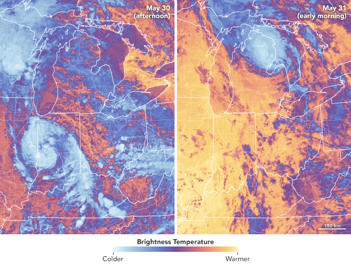
English: The Moderate Resolution Imaging Spectroradiometer (MODIS) on NASA’s Aqua satellite captured these images of the storm. The false-color views use MODIS band 31, which measures infrared signals known as brightness temperature. This band is useful for distinguishing cooler cloud structures from the warmer surface below.
The left image shows the storm at 1:25 p.m. Central Time (18:25 Universal Time) on May 30, 2018, as it moved across west-central Indiana. At the time, Alberto had maximum sustained winds of 45 kilometers (30 miles) per hour. The right image shows the storm at 3:05 a.m. Central Time (08:05 Universal Time) on May 31. By this time, Alberto had become a post-tropical cyclone as it moved from away from lower Michigan toward the north-northeast. |
| Date | |
| Source | https://earthobservatory.nasa.gov/NaturalHazards/view.php?id=92221 |
| Author | NASA Earth Observatory |
Licensing
edit
| This file is in the public domain in the United States because it was solely created by NASA. NASA copyright policy states that "NASA material is not protected by copyright unless noted". (See Template:PD-USGov, NASA copyright policy page or JPL Image Use Policy.) | ||
 |
Warnings:
|
File history
Click on a date/time to view the file as it appeared at that time.
| Date/Time | Thumbnail | Dimensions | User | Comment | |
|---|---|---|---|---|---|
| current | 06:34, 4 June 2018 | | 720 × 545 (693 KB) | A1Cafel (talk | contribs) | User created page with UploadWizard |
You cannot overwrite this file.
File usage on Commons
There are no pages that use this file.